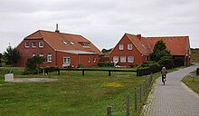
Langeoog dairy
The dairy is a building on the German North Sea island of Langeoog .
It was built in 1741 by the then island bailiff Hayduck Taaken on the eastern end of the island as a residence and is located about eight kilometers from the island's town hall in the center of the village. In 1764 Adde Röben took over the lease of the Ostend, whose son-in-law and later island bailiff, Gerjet Ludwig Kuper, succeeded him as the lessee. However, after his appointment as island bailiff and mayor, he later moved to the western village of the island.
However , it was only given the name dairy in 1895. The official name of the dairy was "Domain Ostend" and agriculture was practiced here until it was closed in 1953. For a long time the dairy belonged to the Loccum monastery and served to supply the island hospice with agricultural products. From at least 1828 the dairy officially housed a "jug tavern". As early as 1768, however, the tenant at the time was granted this right by contract with the princely administration in Aurich. Even today there is a restaurant there. Here you can see two French cannon balls from the time of the continental barrier, which were found during excavation work close to 1.80 meters below the surface of the earth.
On October 22, 1962, a fire destroyed part of the building, so most of the main building was rebuilt in 1963. In 1971 a connection to the village in the west of the island was established by means of a cycle path. There are also carriage rides on the island. The dairy has been protected by a 5.20 meter high dike since 1975. There is also a 0.9 to 1.1 meter high summer dike, which leads from the sea dike to the dairy at the wading edge.
literature
- Der Kleine Langeoog-Führer , F. Runge, 1986, p. 33f
Web links
- falke-meierei.de: The history of dairy farming
Individual evidence
- ^ History of the East Frisian tea room on the Langeooger tea room "Am Hafen" website ( Memento from April 4, 2005 in the Internet Archive )
Coordinates: 53 ° 45 ′ 0.5 ″ N , 7 ° 35 ′ 40.5 ″ E

