Melville Island (Australia)
| Melville Island | |
|---|---|
| Tiwi Islands (Melville is the larger island) | |
| Waters | Timor Sea |
| Archipelago | Tiwi Islands |
| Geographical location | 11 ° 33 ′ S , 130 ° 56 ′ E |
| surface | 5 786 km² |
| Highest elevation | Mount Walter 102 m |
| Residents | 1030 <1 inh / km² |
| main place | Milikapiti |
| Topographic map sheet (1944) | |
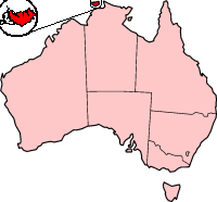
Melville Island is located off the coast of the Northern Territory of Australia . The country's second largest island after Tasmania covers a land area of 5786 km² and, together with Bathurst Island and around nine much smaller coastal islands, forms the archipelago of the Tiwi Islands .
As part of the Timor Sea , Melville Island is separated from mainland Australia by the Clarence Strait in the south , while the Apsley Strait , which is only one to five kilometers wide, separates it from neighboring Bathurst Island.
Like the Arnhem Land , the island of Melville is practically a reserve closed to tourism for the Aborigines , the indigenous people of Australia, who live on it . The approximately 600 Aborigines of Melville Island live relatively independently of the mainland and also have their own administration.
Melville Island was first sighted by Dutch navigator Abel Tasman in 1644 and was named in 1818 in honor of Robert Dundas, 2nd Viscount Melville , a British nobleman and long-time First Lord of the Admiralty.


