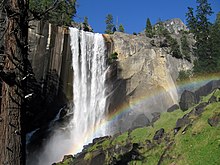
Merced River
| Merced River | ||
|
Merced River in the Yosemite Valley |
||
| Data | ||
| Water code | US : 272412 | |
| location | California (USA) | |
| River system | San Joaquin River | |
| Drain over | San Joaquin River → Suisun Bay | |
| confluence | from Lyell Fork Merced River and Merced Peak Fork in Yosemite National Park 37 ° 42 ′ 3 ″ N , 119 ° 20 ′ 51 ″ W |
|
| Source height | 2413 m | |
| muzzle |
San Joaquin River Coordinates: 37 ° 21′0 ″ N , 120 ° 58′30 ″ W 37 ° 21′0 ″ N , 120 ° 58′30 ″ W. |
|
| Mouth height | 17 m | |
| Height difference | 2396 m | |
| Bottom slope | 13 ‰ | |
| length | 180 km | |
| Catchment area | 4470 km² | |
| Reservoirs flowed through | Lake McClure | |
The Merced River is a river in the US state of California . It is a 180 km long tributary of the San Joaquin River . The Merced River rises in the southern part of the Yosemite National Park and then flows through the Yosemite Valley . Much of its water is captured by two dams, the New Exchequer Dam , which forms Lake McClure , and the Crocker-Huffman Diversion Dam . The sparse remainder of the river then flows into the San Joaquin River.
The course of the Merced in Yosemite National Park is designated as a National Wild and Scenic River . The management of the river course in this section has been the subject of longstanding disputes and legal proceedings. Nature conservationists accuse the park administration of damaging the ecological and scenic value of the river through tourist facilities and uses.
In February 2014, a new management plan for the river section in Yosemite Valley was presented, which for the first time provides for an upper limit for the daily number of visitors to the valley. In addition, around 80 hectares of banks are to be renatured and armor stones removed from around 2000 m of the bank line .
Web links
Individual evidence
- ↑ National Park Service: Yosemite National Park - Merced River Plan

