Metro Bridge (Kiev)
Coordinates: 50 ° 26 ′ 34 ″ N , 30 ° 33 ′ 52 ″ E
| Metro bridge | ||
|---|---|---|
| The metro bridge over the Dnieper near Kiev | ||
| Official name | Міст Метро / Mist Metro | |
| Crossing of | Dnepr | |
| place | Kiev , Ukraine | |
| construction | Reinforced concrete arch bridge | |
| overall length | 684 m | |
| width | 28 m | |
| opening | November 5, 1965 | |
| location | ||
|
|
||
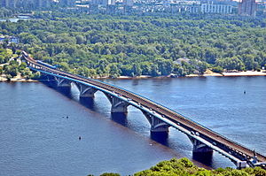
The Metro Bridge ( Ukrainian Міст Метро / Mist Metro , Russian Мост Метро / Most Metro ) is an arch bridge over the Dnieper in the center of the Ukrainian capital Kiev .
The combined road and underground bridge has five arches and is almost at the site of the Nikolaus Chain Bridge that stood here until 1920 . It leads from the right Dneprufer ( Dnipro metro station ) to the Venetsianskyi Island with the Hidropark ( Hidropark metro station ) on top .
The chief engineer of the bridge, which opened on November 5, 1965, was the Kiev architect Heorhij Fuks .
The bridge has a length of 684.5 m, a width of 28 m and is located 20 m above the river. It has a two-tier structure. At the top there are two tracks for the Kiev metro , at the bottom the bridge has four lanes for road traffic ( N 07 ).
Web links
Individual evidence
- ↑ a b Metrobrücke on structurae.de , accessed on September 20, 2015
- ↑ a b c d Metrobrücke on unique.in.ua , accessed on September 20, 2015
- ↑ Metro Bridge in the Kiev Encyclopedia , accessed September 20, 2015
- ↑ Metro bridge on go2kiev.com , accessed on September 20, 2015
- ↑ Bridges over the Dnepr at travelua.com.ua , accessed on September 20, 2015


