Mombasa Island
| Mombasa Island | ||
|---|---|---|
| Mombasa Island at night | ||
| Waters | Indian Ocean | |
| Geographical location | 4 ° 3 ′ 0 ″ S , 39 ° 40 ′ 0 ″ E | |
|
|
||
| length | 5.5 km | |
| width | 3.8 km | |
| surface | 14.1 km² | |
| Highest elevation | 5 m | |
| Residents | 146.334 10,378 inhabitants / km² |
|
| main place | Mombasa | |
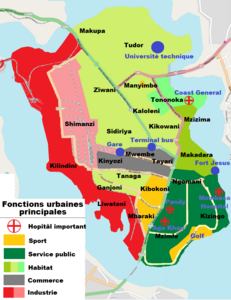
| Map of Mombasa Island | ||
Mombasa Island is an island almost six by four kilometers in the south of Kenya . The old town of Mombasa is located on the island.
The island forms the Mombasa Island Division , one of four divisions of Mombasa County .
geography
Mombasa Island only borders the open Indian Ocean in the southeast. To the west lies the Kilindini Port , an arm of the sea, and to the east is the estuary of the Tudor Creek .
Infrastructure
Mombasa Island is connected to the mainland by the Makupa Strait in the northwest and the Nyali Bridge in the northeast. To the south, you can reach the mainland by taking the Likoni ferry that crosses Kilindini Port.
The old town of Mombasa is located in the southeast of the island, the modern deep-sea port Port Reitz in the northwest. This is connected to the mainland by a railway bridge and a road (Kibarani / Makupa Causeway).
Mombasa is also connected to Nairobi and Uganda by a railway line and has an international airport ( Moi International Airport ).


