
Mona Island Tramway
| Mona Island Tramway | |||||||||||||||||||||||||||||
|---|---|---|---|---|---|---|---|---|---|---|---|---|---|---|---|---|---|---|---|---|---|---|---|---|---|---|---|---|---|
 Donkey drawn wagon, 1922
| |||||||||||||||||||||||||||||
 Route, 1904
| |||||||||||||||||||||||||||||
| Route length: | 1.8 km | ||||||||||||||||||||||||||||
| Gauge : | 600 mm ( narrow gauge ) | ||||||||||||||||||||||||||||
| Maximum slope : | 500 ‰ | ||||||||||||||||||||||||||||
|
|||||||||||||||||||||||||||||
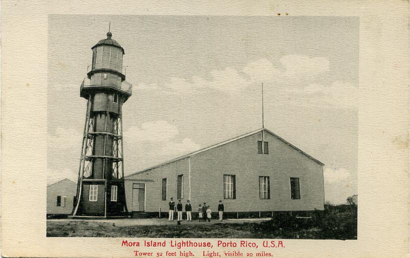
The Mona Island Tramway ( Spanish : Tranvía de la Isla de Mona) was a 2-kilometer narrow-gauge railway with a gauge of 600 mm on the island of Mona in the Caribbean Sea , which belongs to Puerto Rico . It was relocated in the 1890s to move building materials from the beach to the construction site of the 16-meter (52- foot ) lighthouse that went into operation on April 30, 1900 .
Route

.JPG)
The route consisted of two unconnected sections. The most port on the Playa La Escalera goods unloaded were on a 70 meters (231 feet long), with a steam winch powered funicular to Cueva Escalera brought cave above. A staircase led through this cave to the island's plateau, 37 m (122 feet) above sea level, on which a 1.8 km section led to the lighthouse. A storm destroyed the facilities at Playa Escalera , whereupon Playa Pájaros, 5 kilometers (3 miles) away , was used for shipping.
The hurricane of September 1921 removed the roof of a lighthouse storage room and damaged the kitchen and the light railroad . The inspection report from the US Department Commerce 1922 emphasizes the difficulties of getting to the lighthouse, from mooring with a wind blowing landward, over reefs, a mile over a cactus-covered footpath along the beach from Playa de Pajaro to Cueva de Escalera, with the first Light railroad a 50% incline to the cave, using the stairs leading through the cave, and then another 6,000 feet (1.8 km) on the second light railroad, which often derailed because the 22 year old rails were falling apart. In 1925, the one with a sun protection canopy was pulled by "Macario," a stubborn donkey. The construction of a road that could be used by cars began in 1927, after which the light railroad lost its importance.
Gauge
Since the building material for the lighthouse was specified, prefabricated and delivered by the French design office Stapfer de Duclos & Cie, it can be assumed that a flying track with conventional narrow-gauge rails from the Decauville company with a gauge of 600 mm instead of the 610 mm usual in Puerto Rico (2 feet ) was inserted.
More narrow-gauge railways
There were other narrow-gauge railways on the island, which were used for mining guano in the caves on the coast. Most of the rails have been removed from the caves. A few 4 m long track segments with a gauge of 500 mm are located in the Cueva del Diamante and several other caves. The only longer stretch that is still preserved is in the Cueva del Lirio .
Individual evidence
- ^ A b Kraig Anderson: Isla de Mona Lighthouse. Retrieved August 25, 2018.
- ↑ Mona Island Lighthouse, Porto Rico, USA - Tower 52 feet high. Light, visible 20 miles. Retrieved August 25, 2018.
- ^ Roger W. Aponte: Railroads of Puerto Rico / Ferrocarriles de Puerto Rico. (English Spanish)
- ^ Roger W. Aponte: Railroads of Puerto Rico / Ferrocarriles de Puerto Rico. (English Spanish)
- ^ Frank H. Wadsworth: Mona Island - The Mining Period (1848-1927). January 28, 2016. Retrieved August 25, 2018.
- ^ Edward F. Frank: History of the Guano Mining Industry, Isla de Mona, Puerto Rico. In: Journal of Cave and Karst Studies , 60 (2), August 1998, pp. 121-125.
Coordinates: 18 ° 5 ′ 10.8 " N , 67 ° 50 ′ 47" W.