Mont Puke
| Mont Puke | ||
|---|---|---|
| height | 524 m | |
| location | Futuna , Horn Islands | |
| Coordinates | 14 ° 16 ′ 14 ″ S , 178 ° 8 ′ 21 ″ W | |
|
|
||
| particularities | Highest mountain of the French. Wallis and Futuna overseas territory | |
|
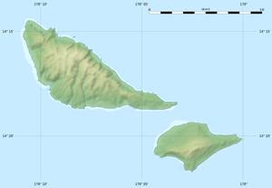
Map of the Horn Islands |
||
The Mont Puke (also called Mont Singavi or, after Willem Schouten , Mont Schouten ) is at 524 m above sea level, the highest point in the French overseas territory of Wallis and Futuna .
Location and surroundings
Mont Puke is located on the island of Futuna , the summit is around 1.5 km from the northern coast. Neighboring mountains are the Mont Kalufatufatu ( 473 m ) and the Mont Kofua ( 503 m ) in the west and the Toafa Magalua ( 459 m ) in the southeast. Three hundred meters northeast of the main summit is the 502 m high Matagitoga pre-summit . The Mont Puke is forested. In a west-east direction a path leads over the summit.
Mythology and history
In the Polynesian mythology of Futuna, Finelasi , daughter of Mago and Tafaleata and protector goddess of the island, resided on the summit of Mont Puke, where she had fled after the incestuous relationship with her brother Fakavelikele .
The affiliation of the Mont Puke was long disputed between the kingdoms of Alo and Sigave . It is surrounded by a wall called Atufatutea, which, according to tradition, was built to resolve the border dispute in a competition. Whoever managed to build a wall around the summit first should own the mountain.
Today's border between the two kingdoms runs across Mont Puke.
literature
- Daniel Frimigacc: Aux temps de la terre noire - ethnoarchéologie des îles Futuna et Alofi . Peeters, Paris 1990, ISBN 2-87723-030-9 , pp. 23-24, 54, 73, 106 (French).
Individual evidence
- ^ Wallis-et-Futuna. Geography. République française - Ministère des Outre-mer, November 30, 2016, accessed on December 2, 2017 (French).

