
Mount Popa
| Mount Popa | ||
|---|---|---|
 |
||
| height | 1518 m | |
| location | Nyaung U (District) , Myanmar | |
| Coordinates | 20 ° 55 '19 " N , 95 ° 14' 56" E | |
|
||
| Type | Stratovolcano | |
| Last eruption | 442 BC Chr. | |
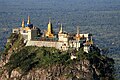
 Monastery on the Taung Kalat |
||

The Mount Popa is an inactive volcano in the Myingyan level in central Myanmar , about 50 kilometers southeast of the temple city of Bagan in Mandalay Division .
Occasionally the 737 m high, southwestern volcanic cone Popa Taung Kalat is also referred to as Mount Popa. At the top is the Tuyin Taung Pagoda . Many monkeys live by and on the roofed staircase leading up to it and feed on the gifts of the visitors.
Mount Popa is considered to be the home of the Nats , the patron saints of Myanmar .
geology
The main complex of the volcano consists of basaltic and basaltic - andesitic lava flows, which, together with pyroclastic deposits and pumice stone, were ejected during strombolian eruptions, which led to the growth of the volcano. The volcano also has a 1.6 km wide and 850 meters deep caldera, which has opened to the northwest as a result of slope collapses. A 3 km³ debris flow can be found in the north of the slope collapse.
photos

View from Mount Popa to the Taung Kalat
The Tuyin Taung Pagoda on the Taung Kalat volcanic cone


Web links
- Mount Popa in the Global Volcanism Program of the Smithsonian Institution (English)