
Nyaung U (District)

Nyaung U is a district in central Myanmar . It is located in the southwest of the Mandalay region . Its administrative and functional center is the city of the same name, Nyaung U , which had 48,528 inhabitants in 2014. The district consists of the two townships Nyaung U and, since 2014, Kyaukpadaung. Kyaukpadaung Township was previously part of Myingyan District. The total area of the district is since then 3423.1 km² and the total population in 2014 was 501,855 inhabitants.
geography
topography
In the south, west and north the district borders on the Magwe region . It is bordered by the Myingyan District to the east and the Meiktila District to the southeast . The north-south extension of the district is up to 74.3 kilometers, the east-west extension up to 68.8 kilometers. The three core towns of the Nyaung U Township, Nyaung U, Old Bagan and New Bagan are all on the Irrawaddy River and form a triangle with each other, which are connected by several paved roads, including Route 2.
The city of Pakokku is located on the northern bank of the Irrawaddy 30 kilometers northeast of Bagan and is the closest metropolitan center of the district and can be reached via the newly built Pakokku Bridge in 2009 .
The only significant river is the Irrawaddy . Its north to south-west course of the river forms the north-western border of the district. The flow is not regulated. Temporary river islands and new river arms are formed due to the high proportion of sediment carried along. Parts of the islands are flooded and washed away every year. The river is the most important source of water for the district. There are more than a dozen other temporary river courses in the district, the river beds of which are only filled with water during the rainy season.
The Nyaung-U district is located in the central dry zone of Myanmar. The vegetation is mostly withered, brownish and monotonous in the dry season. In the savannah landscape , villages alternate with palm groves and open plains. Human settlements and structures appear more densely.
With the Kyet Mauk Taung there is a larger artificial lake in the area of the district. In the center of the Nyaung U township, a range of hills around two kilometers wide runs in a south-north direction , which begins and ends with a length of around 15 kilometers within the township territory and reaches heights of up to 400 meters. Mount Tu Yin is the highest point in the Tu Yin range of hills .
Today's geographical district area comprises a historical landscape with uniform cultural, natural and socio-economic characteristics, which forms an indivisible whole as the Bagan cultural heritage. The Ananda Temple , the Htilominlo Temple , the Dhammayangyi Temple, the Shwesandaw Pagoda , the Bupaya Pagoda and the Shwezigon Pagoda and many other sacred buildings are located in the district area. They are part of the old royal city of Bagan . Today 2376 pagodas still exist. The holy sites have been combined as the Bagan Archaeological Zone into an 8 km × 13 km protection zone and lie entirely within the district area. The area is located in an earthquake prone zone. The last earthquake was on August 24, 2016 with a magnitude of 6.8 (7) with an epicenter about 40 km southwest of Bagan, which caused damage to the historical sites. Some buildings were restored with international help, while others had a makeshift restoration by the military government.
- Landscape scenes in Nyaung U District 2012-2016

Bagan, temples scattered in the landscape
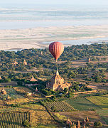
Hot air balloon over Bagan, with the Irrawaddy in the background, December 2012
Mount Popa and the Youk-soun Kyaung teak monastery , landscape of the Kyaukpadaung township

Around Bagan captured from the top of a pagoda
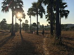
Palm trees near Bagan
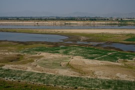
The meandering Irrawaddy at the end of the dry season in March 2016, you can see the extensive sandbanks on the banks of Bagan, looking north

With the ferry on the Irrawaddy from Bagan to Mandalay, in the background Bagan in the sunset, with hot air balloons on tour, November 2013

The up to 400 meters high Tu Yin range of hills not far from Bagan in the township of Nyaung-U


.jpeg)

_-_panoramio_(57).jpg)
climate
There are five local seasons :
- Pre-monsoon: May - June
- Monsoon: July - August
- After monsoons: September - October
- Winter: November - January
- Summer: February - April
Nyaung U District has the highest temperatures of any region in Myanmar. The months from January to March are warm and dry, and there is seldom rain. From March it will be hot and dry, although the temperature differences are not very high all year round. It is permanently warm to hot and the average annual temperature is 27.9 degrees Celsius. The maximum daily temperature at this time is usually between 33 and 35 degrees Celsius. However, maximum values of 43 degrees Celsius can also be reached. The temperatures do not vary very much and the minimum temperature of just over 20 degrees Celsius is only 10 degrees Celsius different from the general maximum temperatures.
In the city of Nyaung U, an average of 618.9 millimeters of rain per square meter fall year-round. The variation in precipitation in the region ranges from 508 and 1016 mm rainfall per square meter, depending on the location. However, this falls unevenly over time. The dry season lasts from the beginning of December to the end of March with a total rainfall of just 12.1 millimeters of rain per square meter. The reason for the seasonally unevenly distributed rainfall is the up to 3000 meter high peaks of the Rakhine Yoma in western Myanmar. The peaks hold off the heavy rain clouds of the monsoons . The monsoon rains during the rainy season from early April to November are bimodal with a month-long dry period in July when dry, drying winds blow from the south. Most of the rain of the year falls in August, September and October. This is the time when the sunshine time is least.
According to the Köppen classification, the area falls into the wet tropical savannah category ( Köppen Code AW ). Comparable climatic regions of the world would be Jamaica , the Northern Territory of Australia or Panama . The climate, and in particular the times and amounts of precipitation, influence the local economy and, in particular, the primarily important agricultural economy, for example in the choice of cultivated plants. The lack of rain often leads to water shortages and crop losses. As a result, the rural population is threatened in their existence. Overall, the rainfall in the long-term observation has decreased. The rainy season has also changed.
In the long term, the average annual rainfall in the Nyaung U district developed as follows:
- 1981: 765 mm
- 1991: 517 mm
- 2001: 556 mm
- 2009: 374 mm
The climate projections for the area predict a general rise in temperature in the future, an increase in the variability of precipitation during the rainy season, an increase in the risk of flooding as a result of a late onset and premature decline of monsoon rains, and an increase in the occurrence and intensity of extreme weather events, including cyclones , floods, intense rainfall , extremely high temperatures and drought.
Natural events
The region lies in a tectonically insecure zone. Myanmar lies on the eastern edge of the border between the Indian and Burma plates in a subduction zone . The district is located in Myanmar's Seismic Zone IV ("Severe Zone"). The intensity of earthquakes range between VIII (destructive) and IX (devastating) on the Mercalli scale (MMS) with expected ground accelerations of 0.30–0.40 g.
Many of the local earthquakes with shallow focus occur in the region due to both leaf displacement and upheaval . Both the active Sunda megathrust in the Indian Ocean and the Sagaing Fault cut through the district and are the main causes of the tectonic unrest in the area. The site is also surrounded by two other large active faults, the Chauk-Yenanchaung fault and the Gwe-cho fault .
Due to the proximity to the Irrawaddy and its tributaries, the riparian area is exposed to flooding and river bank erosion. During the monsoon season from May to October, tributaries are usually flooded three or more times, affecting living space and livelihoods in low-lying communities as well as traffic.
Probably in connection with climate change , the region is becoming increasingly deserted . Man-made interventions such as deforestation but also erosion and increasing salinity have intensified this process. There are an average of five forest fires a year. City and forest fires are a major threat in the dry season (roughly November to May); Fires caused almost 70 percent of the recorded catastrophic events. These can represent a significant health hazard for residents and visitors and directly damage the locations.
Relief and nature reserves


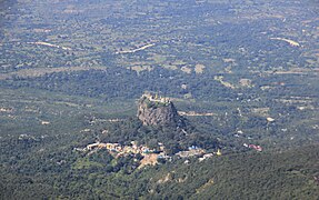
The relief runs steadily increasing from west to east. On the western border near the river bank, the average height is 60 meters above sea level and on the eastern border of the township of Nyaung U it is 480 meters above sea level. The plateau that begins here , the Pegu-Joma , continues in a westerly direction in the Kyaukpadaung Township, which belongs to the district, and reaches its climax there with Mount Popa . The 129 km² Popa Mountain National Park, established in 1989, extends around Mount Popa . It is 67 kilometers from the historic sites of Bagan. Here the climate is cooler and the bidoviversity is richer than in the surrounding area. The landscape there is lined with palmyra palms . Since the altitude above sea level is generally higher in the eastern areas, the climate there is overall somewhat cooler and has higher precipitation values. As a result, there are more forests and greater biodiversity than in the lower western parts of the district. Not far from Mount Popa is the Popa Taung Kalat volcanic cone. The Buddhist monastery on Popa Taung Kalut is one of the most important pilgrimage sites for Buddhist monks, believers and nuns.
Flora and fauna
Due to the semi-arid climate, tree plants that are used to dryness are predominant. Dry deciduous forests dominate, such as wing fruit plants and Than-Dahat forests , which consist of two dominant tree species ( Terminalia Oliveri or Myrobalanen and Tectona hamiltoniana ). Other local dry species that are planted in the increased local forest plantations include, for example, Acacia and Eucalyptus . Furthermore neem , tamarind and euphorbias are common. Other native plants are the Bombax malabarica , Shorea obtusa , Vachellia leucophloea , Ficus neriifolia . Bamboo grows on Mount Popa. There are also teak trees and Pentacme siamensi , Artocarpus integrifolia and the Chinese jujube .
The nature of the forests examined in a study village in 2014 showed that the forest was relatively healthy, with existing soil vegetation and erosion protection . Smaller wildlife was present and there was adequate biodiversity . As a result of the expansion of agricultural areas, deforestation for the purpose of firewood or because of the general infrastructural development, the forest population in the area has been reduced overall. Due to the climate, reforestation is not without problems. For this purpose, the Green Department was established in 1997 in the region for the dry zone .

Macaque monkeys are common on Mount Popa. There are four endemic bird species, including the Burmese bush lark and the white -necked thrush , as well as an above-average number of snake species that especially feel at home in the dark corners of the temple buildings. In the middle of the 19th century, elephants , sambars and tigers roamed the area. Around 1900 there were still leopards and seraues that were hunted. Lyre deer were already rare around 1900. Wild dogs that hunted in packs were mostly found in the Kyaukpadaung township around 1900.
Floors
A 1996 soil survey in Kyaukpadaung classified the existing soils as sandy soil (including gravel), sandy loam, and loamy soil, which differ depending on the landform. The soil type was exposed in ten soil samples taken in Nyaung U township:
The cation exchange capacity was low in four soil samples, very low in five samples and average in only one sample. The base saturation level of Ca was in the low range in seven out of ten samples. In the case of Na, on the other hand, the majority of the samples showed medium or very high degrees of base saturation. In the case of Mg , the degrees of saturation were predominantly medium or low. on. The pH value is just above 6.0. The increased soil alkalinity is mainly caused by the use of saline groundwater for irrigation.
According to the classification of soils according to the World Reference Base , the following types of soil existed in the township of Kyaukpadaung :
The soils have the following characteristics: 1) low fertility, 2) low humus content, 3) low water storage capacity and 4) high evaporation rate. Generally the soils contain potash salt . All crops with the exception of legumes must be supplied with additional nitrogen . Ortstein is present in almost all soils. The soil erosion , the areas located in the higher is particularly strong, is largely due to intense rainfall and rapid surface runoff. The sandy loam soils are particularly prone to wind erosion . Soil erosion is exacerbated by deforestation. The strongly pronounced soil degradation in Nyaung U is intensified, as in the entire dry zone, by increasing soil salinity through evaporation processes, leaching of the soil in the rainy season through rapidly draining rainwater. Agricultural use, overgrazing, deforestation due to agricultural expansion, commercial and illegal logging, excessive felling of charcoal and firewood trees are also factors that have favored this process on site. All of this is exacerbated by population growth. Soil degradation leads to decreased production (through loss of topsoil and nutrients), loss of productive land (through sludge formation and reduced vegetation cover) and effects on infrastructure (through silting of ponds, sedimentation in canals and damage to pumps from high Sediment loads in the water). High sediment loads also pose a major challenge for shipping on rivers, especially in the dry season.
The nutrient values of the soil are depleted and show a low level of organic matter or humus cover . There are intermediate plantings with pigeon peas and peanut plants. However, the primary use is intended as a supply for pets and not for replenishing the organic content in the soil. Local agriculture therefore uses artificial fertilizers but also animal manure . The misuse of fertilizers and pesticides as well as the agricultural overexploitation of the land also lead to a reduction in soil productivity.
Water balance and land use
There is sufficient groundwater in the soil. District data on the new groundwater formation rate, translated into area equivalents, result in values of 30 to 90 mm of precipitation per square meter per year. The use of groundwater for human needs can therefore only take place as one source alongside others. In comparison, the abstraction potential is less than two percent of the existing surface water resource (Irrawaddy) and around 50 percent of the total amount of surface water artificially stored by dams.
In 2013, Nyaung U township comprised 665.61 km² of the total area of agricultural land. This corresponds to a ratio of 45.6 percent cultivated land to the total area. 18.6 km² of forest area was protected as a nature reserve. The other forest area on the township Nyaung U was 150.7 km². In the township of Kyaukpadaung, 62 percent of the area has been used for agriculture. The remaining areas consist to a large extent of partially deforested areas, which are nevertheless used informally for agriculture. These 0.4 to four hectare area carpets are not officially recognized as usable area, but are of great importance to the local population. The land use of these non-owned areas is based on usus fructus rights. The informal development takes place in monoculture . Above all, leaf litter , straw, wood and stakes are harvested from these areas , for example for use as building materials for houses, fuel or as raw materials for the local lacquer art industry. In the vicinity of the villages there are mainly free-range pastures for domestic cattle. This still existing form of cultivation shows clear features of a subsistence economy . Because of the lack of firewood in Kyaukpadaung, the government planned to set up specialized plantations for firewood production.
traffic
The traffic-related infrastructure corresponds to the status of a developing country. Overall, the traffic is not condensed. Construction work on public transport routes, traffic safety, but also the means of transport do not meet the norms and standards with regard to occupational safety and general safety requirements of a developed country.
The national trunk road Route 2 crosses the district along the course of the river. Nyang U has one domestic airport, Nyaung U Airport . The two airlines Air Mandalay and Air Bagan fly to Nyaung U daily.
A central railway connection that comes from the south and swings to the east runs through the district. There is one train station in Nyaung U, the Bagan Railway Station . From there there are daily connections to Yangon , Mandalay , Pakokku and Naypyitaw . There is also a bus terminal near the train station, the Bagan Shwe Pyi Highway Bus Terminal , from which destinations across Myanmar can be reached.
The district's second largest city, Kyaukpadaung, also has a train station. There is also a ferry service on the Irrawaddy to the provincial capital of Mandalay. The connection is served by one public and six private ferry operators. Like the rest of the river bank, the landing stage is unsurfaced and natural. There are no developed piers or jetties . Other local public transport as well as individual transport in the district is underdeveloped and poorly regulated. Instead of regular buses, there are tuktuk drivers or (old) taxis. Horse-drawn carriages, ox-carts or simple carts that are pulled by people, like demolished, outdated and unsafe trucks, are also part of the streetscape in the district. The roofs of moving vehicles are also used to transport people or goods.
E-bikes are now a well-represented vehicle category. These modes of transport are mainly used in the tourism sector. In Bagan alone there were 10,000 registered e-bikes around 2016.
- Traffic and street scenes in Nyaung U District 2009-2016

Nyaung U Airport, 2009
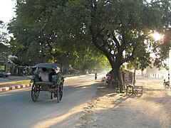
Simple horse-drawn carriage, Nyaung U 2010

River cruise ship on the Irrawaddy to Mandalay in Bagan, 2012

Light passenger traffic in Nyaung U, 2014
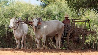
Ox cart near Bagan, 2016

Motorcycles in New Bagan, 2013


_001.jpg)


.jpg)
.jpg)
The roads are divided into five categories, from village roads to country roads. The Ministry of Construction (MOC) and the Township Development Committee (TDC) are responsible for this. Highways and city streets generally have asphalt or tar pavements. Older sections often have lots of potholes and cracks. Most of the lower category roads are unpaved. In the dry phase, this results in the problem of a high volume of dust that severely restricts the view. In the rainy phase, muddy surfaces form on the paths, which limit usability. Since the paved roads usually do not have any rainwater sewers either, the rainwater flows off on the road surface. This leads to flooding and regularly closes the streets for several hours to several days.
A significant number of rural communities do not have adequate road access to the three main towns in the district. As a result, the residents of the communities are considerably hindered from participating in the supra-local economic life.
Street lights are only installed in part of the city street, and after sunset, many streets are dark and visibility is poor. This is a particularly dangerous situation for tourists who return by e-bike after sunset.
There is no regulated parking system or regular public parking spaces, with the result that vehicles are parked chaotically. This leads to unmanageable situations, particularly with mass contact points.
history
As the core area of the Kingdom of Bagan

The area of today's district was the center of the largest Buddhist empire in the medieval world, which emerged with Bagan as the capital in the 9th century ( Kingdom of Bagan ). The rise of Bagan ran parallel to the increasing dominance of the Bamer in Upper Myanmar . In increasing numbers, they advanced from the north and settled along the course of the Irrawaddy . Eventually the Bamer advanced into what is now Bagan. There was already a Pyu settlement there , called Pukan . The Bamer took the city in 849 and made it the capital of their empire. The region formed the first united kingdom of Burma for about 430 years. The heyday reached the Bagan area with the accession to the throne of King Anawrahta and his son Kyanzittha from 1084 to 1113. The rulers of Bagan and the social elite had over 10,000 stone religious monuments erected on a total area of 104 km² in the plain around Bagan. Anyone who founded a temple or a monastery wanted to demonstrate to posterity their deep religiousness. Above all, the pious patron hoped for better opportunities for advancement in his next rebirth. During the heyday, the city's population was between 50,000 and 200,000. The Mongol Invasion ( First Mongol Invasion of Burma ) 1277–1278, 1283–1285 and 1287 accelerated Bagan's decaying process considerably.
In the centuries that followed, Bagan shrank back to the size of a village. The local aristocracy, however, continued the original symbolic patterns of meaning into the 19th century without, of course, exercising any political power. The heirs of the historical legacy continued to refer to themselves as Mintha (Prince). In neighboring Nyaung U, the mayors derived their origin from Manuha , an enslaved king of Thaton , who had been kidnapped by Aniruddha to Bagan.
The riverside town of Nyaung-U is also mentioned in ancient inscriptions, but its growth into a larger city did not come about until much later when it became the commercial center of Burmese lacquer manufacturing in the 18th century.
Colonial administration


In 1856/57 there was a severe famine in the region that left many people dead.
The geologist William Thomas Blanford first explored the area in 1862 and published the research results.
After the Third Anglo-Burmese War , Upper Burma was annexed in 1885. Nyaung-u became the headquarters of the Pagan District. The Pagan District was established in November 1885 after an expeditionary force moved along the Irrawaday River and repeatedly struck the opposing Burmese forces. First of all, the war was followed by a phase of small-scale military combat.
A parent district, headquartered in Myingyan, was also established in 1885 when the Mandalay expedition passed the Irrawaddy, and Pagan (Bagan) became the headquarters of a second deputy commissioner in Myingyan district. From then on there was the Township Pagan and Kyaukpadaung and above that the Pagan Subdivision , which in turn was hierarchically below the Myingyan District. The second parallel subdivision of the Myingyan District was called "Myingyan Subdivision" and consisted of three other townships. The Pagan Subdivision initially included the townships Pagan, Kyaukpadaung and Sale, parts of Meiktila and Magwe and the entire Pakokku district of today . But the Pakokku and Meiktila districts were formed shortly thereafter and separated from the subdivision.
In the wake of the British annexation, local administrators surrendered to the military expedition, and there was no open hostility. The Burmese governor joined the Shwegyobyu insurgents in Pakangyi, Pakokku district , after six months . During these early days of British rule, riverside trade flourished, but in 1886 parts of the district were practically occupied by dacoitys (bandits in India). This happened particularly in the area south of Bagan. The northern and eastern areas, however, were kept quiet to some extent by the establishment of posts in Sameikkon on the Irrawaddy and in Natogyi inland to the northeast of the district. Combined operations at Myingyan and Ava put an end to the insurgency under Thinga Yaza . The mountain valleys around Mount Popa remained the refuge of robbers for a long time and at least one Dacoit was still at large ten years after the British annexation in this area. In 1887, a leader named Nga Cho caused serious problems in the south, and a second insurgent, Nga Tok , worried the northern areas. The latter was killed in 1888; But the former and another leader, Yan Nyun , who was famous for his atrocities, continued to conduct violence in the district for two years. By 1889 all of Myingyan, with the exception of the Popa tract, was free of dacoits. But it wasn't until Van Nyun surrendered that the entire district could be considered pacified. Nga Cho stayed at large six years longer, but ceased to be a dangerous leader when Van Nyun gave up.
The area of the two newly built townships were:
- Kyaukpadaung Township: 3150.8 km² (today: 1964.1 km²)
- Pagan Township: 1,506.8 km² (today: 1,459 km²)
The populations of the two townships were:
- Kyaukpadaung Township: 1891: 66,608 inhabitants, 1901: 68,043 inhabitants
- Pagan Township: 1891: 49,606 inhabitants, 1901: 56,971 inhabitants
In 1896/97 there was a famine due to the lack of rain, which was successfully fought by additional food deliveries.
The number of settlements was:
- Kyaukpadaung Township: 304 villages with Kyaukpadaung as township headquarters had a population of 907 in 1901.
- Township Pagan: 189 villages with Nyaung-U as the main town had a population of 6,254 in 1901.
In 1903 the:
- Townships Kyaukpadaung: 507.4 km²,
- Townships Pagan 388.3 km² cultivated.
The local economic activities at that time ranged from 15 local fisheries, a primitive salt production, textile production to lacquer art production. Export-oriented trade transactions were carried out through the district center of Myingyan. The trade there was controlled by Chinese and Indians. But the Burmese were the owners of the company on site. Imports and exports, mainly agricultural products, were transported by the Irrawady river steamship and the railway that already existed in Myingyan. Even then, road construction was organized by public authorities. There were already budgets for this and by 1900 the Pagan Township had around 212 kilometers of paved roads. The Irrawady Flotilla Company operated on the river , whose ships transported mail and goods alongside passengers and headed for Nyaung U as planned. The administration also operated a ferry at Nyaung U. Livestock theft was the most common form of crime. The military police , which belonged to the Mandalay battalion, maintained U-30s in NYaug and another 30 police officers in Kyaukpadaung. The place of jurisdiction at that time was Myingyan. There was one of the two district prisons near Bagan. This had 60 places, half of which were lepers .
The tax revenues, including the Thathameda, were:
- Kyaukpadaung township: 116,000 Burmese rupees (Rs), which corresponds to around € 17.183 million in today's currency.
- Township Pagan: 77,000 Burmese rupees (Rs), which corresponds to around € 11.406 million in today's currency
The illiteracy rate was 1901 in:
- Nyaung U Township: 76.8%
- Kyaukpadaung Township: 79.6%
In 1901/1903 the Ananda Museum in Bagan was built on the orders of Lord Curzon , who had recognized the archaeological value of the site during a visit. This was rebuilt in 1937/38. After the war-related closure and evacuation of the cultural assets, the museum was reopened in 1954 and expanded in 1979 and 1995. Today it operates under the name Bagan Archaeological Museum . At the time, Dr. Emil Forchhammer in Bagan and researched the temple complexes in 1881. Gordon Hanninton Luce systematically studied Bagan from 1912. His work is considered to be the most important research results on Bagan.
By the First World War , a gradually differentiating administration was set up for Burma Proper , the principles of which were adopted from British India . The level of the districts was introduced by the British government after the Indian model. Above it stood the governor of the Indian province of Burma followed by the viceroy for all of India. At the district level, there were now paid administrative staff who had to be professionally qualified for their task. They replaced the people appointed by the Burmese king, whose posts were mostly inherited. In place of traditional personal rule, rule came through the law. British colonial administration was initially based on the existing indigenous management system at the local level, but evolved over time. The use of indirect rule , particularly in remote areas, was widespread: traditional leaders remained in place, overseen by officers based in Britain. The chief commissioner represented the highest local authority, which acted as "agent of the governor general". A graduated territorial system with township officials and commissioners was created. In addition to the traditional functions, the local colonial administrators expanded their functions to include the federal departments of health, education and forestry. The British administrative structure was based on the Upper Burma Village Regulation Act and the Lower Burma Village Act , which were later revised as the Village Act of 1907 . These laws also codified the roles of the village chiefs, known as thugyi , and gave them powers to oversee local security and assist the district officials.
Around 1900, today's Nyaung-U district did not yet exist. However, the Mandalay region already existed with some of the districts that exist today. In the 1901 census, most of today's district area still belonged to the Myingyan district , which is still there today in a reduced form. The municipality of Pagan / Bagan has been incorporated into the Nyaung-u registration area in both name and status since the 1911 census . From then on, Bagan was classified as an excluded city by the colonial authorities and Nyaung-U was elevated to a city that has since been included in the surveys. In 1911 Nyaung U had 5726 inhabitants. Between 1921 and 1931, the urban population of Nyaung U town rose from 7,094 in 1921 to 8,118 in 1931.
After independence and during the military dictatorship
After the area of today's district was initially occupied by the Japanese conquest of Burma in 1942, it was liberated by Indian-British troops in early 1945 through the battle for Meiktila and Mandalay .
Shortly after gaining independence from the United Kingdom in 1948, a communist uprising began in Burma , which was supported by the Burma Communist Party and which also spread to the district. Kyaukpadaung, which at that time still belonged to the Myingyan district , was conquered by communist insurgents. In January 1950 the city was retaken by government troops. In the following years, too, there were further attacks and attacks by the KPB. In April 1955, communist insurgents stormed the Nyaung U prison and freed 134 prisoners. Many of you were party members.
Many of the administrative institutions of the colonial era were maintained during the post-independence parliamentary rule. Until the military coup in 1962 , the territorial administrative units of Burma were standardized in states, districts, townships, village tracts and wards.
Some infrastructure expansions in the district area took place in the 1960s. In 1960, the Nyaung U landing field was expanded into an airport that can be used all year round and is now served by the Union of Burma Airways . On the occasion of the visit of the Indonesian President Suharto to Bagan, a bypass road south of Bagan was built past Nayung U airport back to Nyaung U so that it could get from the hotel to the airport unhindered. From 1964 to 1970 the railway line between Kyaukpadaung and Gwegyo (towards Rangoon) was built. Around 1970 the Kyaukpadaung-Chauk railway line was continued. This served primarily to transport oil products from the oil fields near Chauk , as well as raw materials and finished products from the fertilizer plants in Salay (Chauk Township).
In September 1988 there were large nationwide demonstrations directed against the military regime and sponsored by the monks. Kyaukpadaung was a major protest center for these uprisings with thousands of demonstrators.
The military rulers blocked the transfer of power to democratically elected representatives across the country for decades. There were also multiple violations of the exercise of freedom of expression and other basic democratic rights by representatives of the regime on site. After the national election victory of the NLD , the junta regime organized a vote of no confidence with 67,000 signatories against U Bo Zan , who had previously been elected for the National League for Democracy during the 1990 elections for the House of Representatives with 70.87 percent of the vote in Kyaukpadaung. Rallies were organized centrally on site in order to obtain the desired number of signatures for the vote of no confidence. This should demonstrate to the public that the election winners of the NLD are no longer supported by the people and thus have no legality to represent the will of the people. This resulted in the use of pressure and violence by the local regime representatives against the local population. For example, those who stayed away from the rallies had to pay a fine and were brought to another rally by force (e.g. kicking in their own house) by the local security structures. After the election was canceled by the regime, the next elections did not take place again until 2010.
During the demonstrations against the military regime in Myanmar in 2007 , violent protests with up to 30,000 participants, including mainly monks, took place in the district, including the township capital of Kayukpadung.
Beginning of the tourist boom

_-_panoramio.jpg)
_-_panoramio_-_mohigan_(9).jpg)
The handling of the historical heritage by government agencies was not done properly in the 20th century. When a team from the Burma Historical Commission visited Bagan in 1957, a temple suddenly disappeared. A public works agency had used all of the building's stones to build the Nyaung U-Kyaukpadaung Highway. Due to the political isolation from 1962 onwards, further international activities ceased. The second major earthquake on the evening of July 8, 1975 struck the pagoda city of Bagan. It completely destroyed two large temples and a large number of other temples and pagodas of various sizes. The earthquake meant a severe blow to the preservation of Bagan's temples.
Tourism began in Bagan in the 1970s, especially for domestic tourism. However, the area wasn't known as a popular tourist destination until the early 1980s. Internationally significant tourism began after Western scholars on site showed a great deal of interest in the historic buildings that were badly damaged by the 1975 earthquake. The number of tourists in Bagan was 13,004 in 1992. The number of tourist arrivals has increased steadily since then. Only with the work of the French Pierre Pichard on behalf of the Ecole francaise d'Extreme-Orient (EFEO) was a comprehensive inventory of the temples created in 1992.
In order to develop the area more for tourism and in the hope that this measure would have a positive effect on the inclusion in the UNESCO World Heritage Program, the people who lived in what is now Old Bagan were moved by the government to the newly created one in the 1990s Relocated to New Bagan. In a short time, 4,000 residents had to leave their homes by order of the government and relocate to the unprepared new quarter without compensation. In the center of New Bagan there are now retail and basic tourist infrastructures. In addition, in 1996 the state created a golf course to promote tourism, the Bagan Nyaung Oo Golf Club , which is located within the UNESCO cultural heritage zone and is operated by the state. At this time, some renovations began. However, the nomination was rejected due to a lack of detailed management plans and provisions for infrastructure and tourism development.
Myanmar only enacted its first law on the protection of cultural heritage - the Law on the Protection and Conservation of Regions of Cultural Heritage - in 1998, two years after its nomination for the World Heritage List was rejected . However, due to rampant corruption and nepotism during the era of military rule, the law was ineffective.
The proper preservation of the site has come with widespread criticism of the military regime in Myanmar. In response, the generals decided to do the restoration, rebuilding, and gilding of the stupas for their own merits, and to build a luxury hotel within the property, thus associating their regime with Bagan's ancient glory. Since there were no guidelines for detailed work, the new designs were not authentic. This process was led by General Khin Nyunt , who was called Bagan's restorer. In 1998 the military regime decided to re-admit foreigners within the country's borders.
From simple farmers to the upper class, funds were donated locally to renovate or rebuild the sacred buildings. In this way, 1299 monuments were created on site between 1995 and 2008, completely new and often not true to the original. Shortly before leaving office in March 2016, the then government approved 42 more hotel construction projects in the zone. The following NLD government subsequently approved 25 of the 42 hotels that had already been built and rejected 17 construction projects that had not yet started.
The new fantasy buildings as well as the tourist structures within the protection zone had no further effects on the application process. In its test report for Bagan's second application for membership in 2018, ICOMOS ruled:
"The nominated property retains its authenticity through the presence of extensive original historical structures, archaeological resources, wall paintings and sculptures."
The area was awarded the Unesco World Heritage title at the next attempt in 2019. To secure this title, however, extensive protective measures, such as the dismantling of tourist structures in the protection zone, must be implemented. With the submission of the “Management Plan” to UNESCO in 2018, Bagan received comprehensive guidelines for the preservation and protection of its heritage, in particular to curb unbridled tourist buildings such as hotels.
Impact of recent state and administrative reforms at the local level

After the saffron revolution of 2007, the country's political culture changed forever. The most recent development of the district has mainly been shaped by the transformation of the central state in recent years. When the country opened up to the outside world, an economic revival began. Comprehensive modernization projects have been formulated by the central government. With foreign capital, every household in the country should be connected to the public electricity grid by 2030.
Various state reforms followed, which were intended to reduce the democratic deficit of the political system throughout the country. This was primarily aimed at decentralizing the local development process in rural areas more strongly and transferring powers such as budget rights more strongly to the local level and introducing new forms of co-determination ( local governance ). As a result, several committees were set up at the federal level in March 2013 in all regions and states, which were carried out nationwide:
In April, following the passing of the Mandalay Region Municipal Affairs Organization Law ( Hluttaw Law no. 3 2013 ), the Township Municipal Affairs Committee was established in the Mandalay region. A fourth institutional planning structure, the township development planning process , was also already being drawn up.
In the Mandalay region there are currently three development budget pots at the township level:
- 1. The Poverty Reduction Fund since 2012, for infrastructure projects (schools, health facilities, road renovation, wells, solar parcels). Amount: one million US dollars annually, financial allocation from the Union for the Mandalay region
- 2. The Rural Development Fund , the budget amount depends on the annual income, works like the Poverty Reduction Fund
- 3. The Constituency Development Fund , since 2013, each township receives 100,000 US dollars for infrastructure projects, the townships have the right to propose.
As a result of the reforms, the strict top-down mode of command and order of the central authorities vis-à-vis local authorities has been reduced. Information and communications are now also carried up from the bottom up to central government offices and used in decision-making.
A 2014 UNDP survey of residents in the Mandalay region found that half of the population felt restricted in their expression and feared sanctions. The population still did not fully trust the state and its representatives to comply with their own laws and basic human rights.
Islamophobia
Fear of Islam has grown sharply across Myanmar in recent years . During the 1970s, de-Islamization had occurred in central Burma and along the transport corridor from Mandalay via Bagan, Magwe and Pyay. Mosques were burned and not rebuilt. The residents of Kyaukpadaung advocated this religious policy of eliminating mosques in the area. The residents of Kyaukpadaung are known for not accepting non-Buddhist residents. In the case of a suspected mosque construction in the city, an angry crowd gathered in front of the construction site in 2017 and successfully demanded its removal. Afterwards it turned out that the building should not be a mosque. The cancellation was carried out anyway.
population
health and safety
Since 2017, an international clinic has been located in New Bagan, the Global Care Bagan Clinic , which provides medical care in this area in addition to the Nyaung U 200 Beded Hospital and Moon & Sun Hospital in Nyaung U and four other clinics in the district's second largest city secures. In 2013, there were 35 rural health centers and 5–10 pharmacies in the Nyaung U township.
During the rainy season, isolated outbreaks of dengue fever occur throughout the entire Mandalay region and thus also in the Nyaung U district .
In the entire zone, 30.8 percent of residents show too little growth. The indicator is classified as a serious public health problem by the WHO . A shortened growth phase in adolescents can be caused by persistently poor access to a sufficiently diverse range of foods, infections and a poor health environment for mother and child. Babies with low birth weight make up 17.2 percent of the total, caused by the small weight gain of the mothers as well as the poor development of the fetus during pregnancy. Almost 90 percent of children between the ages of 6 and 24 months are inadequately fed. Illnesses seem to be caused primarily by malnutrition . Poor hygiene and limited access to sanitary facilities also promote disease. The sick leave of the children is correspondingly pronounced.
The district has a generally good security position and offers a safe environment. The people on the street are considered friendly and hospitable .
Education and culture
The literacy rate in 2014 was 88 to 91 percent of the population in the district and is therefore just as high as the rate for all of Myanmar but slightly lower than the literacy rate within the Mandala region. At the age of 11, after primary school education, significant proportions of a year graduate leave school. Of 3133 eleven-year-olds in 2014, only 2644 children went to secondary school. As a result, around 300 children, i.e. 10 percent of the year, have only minimal elementary school education . Since 10 percent of a year did not receive any schooling at all, around 20 percent of the growing population still have no or only a very low standard of education. Fifty-five percent of a year does not finish secondary school (9 to 10 years of education). Unlike before, numerical gender differences in access to education are no longer statistically verifiable for people born after 2000. The rural population shows a higher educational gap than the urban population. Of those aged over 25 in 2014, 17.1 percent had never attended school. In rural areas, the share of the educationally absent class among those over 25 years of age was 20 percent. The proportion of people over the age of 25 who had graduated from a university or college was only 7.8 percent in 2014.
The vocational school, which was founded in Bagan in 1924 and named Lacquerware Technology College in 2003 , offers 350 to 400 mainly local students a year-long training course in the art of painting. In the second largest city of Kyaukpadaung, the Government Technical Institute Kyaukpadaung has existed since 1993 as a higher educational institution.
In 2013 in Nyaung U township:
- 114 primary schools with 22,735 students and 834 teachers
- 4 secondary schools with 13,424 students and 356 teachers
- 5 high schools with 4,213 students and 125 teachers
Due to the low level of social and economic development on site, cultural social life is not developed. In the regional center of Kyaukpadaung, for example, known as a transport hub with no sights worth mentioning, a private bookstore and library has only been open since 1995 after a 30-year break . There is also a modern cinema in Kyaukpadaung.
Demographics
Between 1983 and 2014, the total district population of both townships increased from 385,442 residents to 501,855 residents. That is a numerical increase of 116,413 inhabitants in 31 years and an average increase of 3755 inhabitants per year.
The birth rate has decreased significantly since 2005. The newborn cohorts after 2005 no longer have the highest numerical values as the age group of those born between 2000 and 2005, but are significantly lower. The fertility rate broken down into the individual townships in 2014 was:
- Nyaung U Township: 1.9 born / female
- Kyaukpadaung Township: 2.1 born / woman
- Ngathayauk Subtownship: 2.0 born / female
This means that there were statistically significantly fewer newborns per woman in the district than for the entire Union of Myanmar. The national average in 2014 was 2.5 births / woman. In the Mandalay region, 280 women die at birth for every 100,000 births. The death rate is twice as high compared to the average in Southeast Asia , which is 140 deaths per 100,000 births. With 282 deaths per 100,000 births, the Union's overall average is somewhat higher than in the Mandalay region, to which the Nayaung U district belongs. The life expectancy in comparison to developed societies significantly lower. In 2014 it was 64.9 years.
Civil society and gender issues
Although civil society on the ground has been forming in the last few years, it remains fragmented and weak and is still at an early stage. The needs of the community cannot effectively take up or represent the forms of representation (e.g. existing parties) that have existed to date, nor can they bundle them into an effective policy which - on their own initiative and would lead to legal, budgetary and regulatory reforms.
In rural areas, women spend significantly more days working on the land than men, both in the monsoon season (approx. 30% more days) and in the dry season (approx. 50% more days) . This is especially true for weed control, pest control and harvesting , although women as well as men are involved in soil preparation. As in other parts of the country, however, women tend to receive lower wages than men for their farm labor, typically 75% of men's daily wages. Women are also typically responsible for tending to small livestock, growing vegetables, and performing post-harvest activities such as separating, grinding, and peeling. They are also primarily responsible for collecting water, firewood and forest products. The use of poor quality technology and equipment by women creates further difficulties. More valuable production goods are usually controlled by men.
Households with female head of household are more likely than poorer households with male head of household . Gender inequality in income distribution is significant. The men receive a higher average per capita income than women 's households because women 's households have little livelihoods (land, livestock and capital) and they are dependent on low-wage work in agriculture as their main source of income.
Religion, ethnicity
.jpg)
.jpg)
The vast majority of the population (more than 95 percent) practice the Buddhist faith. Around 3 percent of the population are members of the Islamic faith and 1.1 percent practice a Christian denomination. Atheists are almost nonexistent. The values are similar for Myanmar as a whole, but the minority religions are a little more pronounced in the national average than in Nyaung U.
Existing Buddhist monasteries are:
Almost 100 percent of the residents belong to the Bamar ethnic group .
Standard of living

.jpg)
.jpg)
.jpg)
.jpg)
.jpg)
income
Overall, the rural population is economically worse off today than in earlier times. The majority of the rural population is considered poor. Around 2018, 60 percent of the households (approx. Four people) in a reference village in the district had less than 75 US dollars a month to live on. In the meantime, due to the ongoing structural crisis in the countryside, economic and social change has begun in the rural population of the district. The subsistence economy is increasingly being displaced by paid wage labor . Through development projects by international NGOs , they have been particularly active in the district since the 2000s to support the authorities in this transformation process from outside. Many young farmers sell their land in order to pursue a regular paid job, either abroad or as employed farm workers in Kayah State .
Household expenses
Food insecurity is a major local development obstacle. Buying enough food through the local market is made difficult by low incomes and high private debt. On average, grocery purchases account for more than half of total household spending (53%). The expenditures for education, health and transport are very low. Almost 40% of households have difficulties meeting their food needs. The primary coping strategy is to reduce the portion size (27%). This leads to low birth weights in newborns, stunted growth in children, and high rates of malnourished mothers, suggesting that the nutritional status of mothers who are pregnant or breastfeeding is worse than that of mothers who do not breastfeed. The rate of waste is of high public health.
The debt of households is high and 35 percent of the loans are used to study data from 2018 right back for the purchase of food. 18 percent of households do not have enough food available, with this being most pronounced for wage laborers and smallholders with less than 2 hectares of land. Rural households have to travel up to two hours to the market to buy groceries. In the rainy season, the travel times are longer. In many villages there are few fresh vegetables available.
Supply infrastructure
_-_panoramio_(13).jpg)
The level of civilizational development and the supply of the population with public goods is at the level of a developing country . Until a few years ago, the traditional way of life, which has been handed down for centuries, applied to the rural population. The cattle slept under the houses, there were no diesel generators or wells.
The local construction is similar to the construction that is typical for the Southeast Asian region. This is especially true for traditional construction . Traditional bamboo houses are still widespread and the most widely used design. Around a quarter of the residential buildings have a bare earth floor. In addition to the use of light building materials from renewable raw materials from the area, the climatically adapted, loose and airy construction of the houses is striking. The houses are usually one-story and at ground level. The public line and grid-bound infrastructure is underdeveloped. There are no sidewalks in many places, and road surfaces are not always paved. The maintenance of private and public buildings and civil engineering is carried out irregularly. A public municipal regulation of the development and the building standards is not pronounced. Unusual structural growth and low building standards result from this. Traffic routing is only partial. There are no lines on the streets. Street lighting is also not available across the board. Other underground pipes (sewage, drinking water, telecommunications) are also not the norm. Only a few households receive electricity from donated solar cells from development aid projects. Only a third of the population is connected to the power grid. The majority primarily use candles , private generators and batteries to generate light .
Oxen and carts are the most valuable possessions of the local rural population. In addition to agricultural work, drawn carts are primarily used to transport goods, but also water that has to be transported from wells. Those who did not have an ox and cart carried the water from pots weighing up to ten kilograms on their head and around their hips for miles into the houses. In the past, due to the persistent drought, the government increasingly drilled wells that were made available to the rural population as public goods.
In terms of ensuring a modern supply infrastructure such as modern living space, clean drinking water, electricity and modern sanitary facilities, around a quarter of the district's residents did not have access to them in 2014. In 2014, fewer than four percent of households had internet access. There were only 1,433 registered cars in Nyaung U Township in 2014. Most have a motorized two-wheeler. With 24,386 registered mopeds / motorcycles only in the township of Nyaung U, this mode of transport is by far the most common. In 2014, the majority of residents continued to use firewood instead of electric or gas stoves to prepare dishes . In 2014, only a minority of households had their own television . Only a little more than half of households also have a radio . Only a third of the population had their own mobile phone in 2014 . With these social indicators, too , the district is at the level of overall Myanmar and somewhat lower than in the Mandalay region.
Development aid and engagement by NGOs
Due to the persistently low level of civilizational development of the population and the public structures, international organizations have been increasingly active on site since 2000 and are running specific application-related development projects in various areas. The primary focus is on meeting the population's primary needs . This includes improving the supply of the population with water for their own consumption, irrigation of agriculture, use of groundwater and river regulation. The establishment of a climate-sensitive agriculture, the production of educational institutions, the distribution of solar technology for electricity generation, improvement of the soil quality by changing the cultivation methods, etc.
The most visible NGO on site is the Food and Agricultural Organization of the United Nations , which has been active in Myanmar since 1978. Your local involvement is aimed at local measures that aim to provide immediate and long-term support for livelihoods in rural areas. This also includes the establishment of government institutions to improve governance in the agricultural sector. A prominent example on site are Farmer Field Schools , which aim to increase the agricultural productivity of the primary crops in the central dry zone by imparting practical knowledge to the local rural population.
Celebrations, celebrations


Religious ceremonies have been celebrated in the Bagan region for a long time. The times of the annual local festivals are based on the lunar calendar . On the morning of the full moon in early January, monks of all ages gather to celebrate the Ananda festival . During this time, hundreds of vendors' stalls were set up around the temples for about a month. During the full moon in November, the Thadinkyut Full Moon Festival (Lantern Festival), which celebrates the end of Buddhist Lent, pagodas and temples are lit with candles, which put the sacred building areas in a festive mood. In addition to these festivals, the temples of Alottawpyae, Loka Nanda , Shwezigon, and Manuha Temple hold their own pagoda festival for a period of two days to a month each year. These festivals are deeply rooted in the consciousness of the local population.
Every year the Nat festival in honor of the Nat takes place in various places and with great effort in the district on the full moon in November / December . The Popa Taung Kalat is the actual center of Nat worship in Myanmar.
economy
Tourism industry
Due to the great tourist importance of this district for Myanmar, there is increasing international package tourism as well as individual backpacking tourism in addition to local domestic tourism and pilgrims. This means that appropriate tourist infrastructures such as hotels and restaurants, including those with Western standards, are available. However, the development is still in the early stages and many tourist standards have not yet been developed on site.

Before the development of tourism, local residents traditionally worked in agriculture. With the development of tourism, tourism-related activities have become a new form of livelihood for local communities. In 2016, the hotels employed 3,200 people, all of whom, with the exception of the board of directors, came from the immediate vicinity. There is no special local tourism school. After in-house training , the trainees are employed as normal specialist employees.
The production of souvenirs for tourists is a source of income for the local population. In 2008 there were only 38,135 foreign tourist arrivals. In 2013, the arrival of nearly 200,000 tourists in Bagan was registered. That meant a 20 percent increase over the previous year. This led to a boom in the tourism industry. New hotels and catering facilities have been built and in turn offer new employment opportunities for the local population. In Bagan alone there were 83 hotels, motels and guest houses with a total of 2,845 rooms in 2016. These accommodation options can be broken down into five categories, ranging from 1 star to 4 stars or unrated. 15% of these facilities have 3 or 4 stars, 15% 2 or 1 star and the remaining 70% have no rating. A total of 182 restaurants were registered in Bagan in 2016. Thereof 80 large restaurants, 57 bistros and 45 cafes.
The following years also meant strong growth in local tourist arrivals. In 2017, 300,441 foreign tourists were registered in Bagan. Most of the foreign visitors came from the USA, the EU and Japan. The number of domestic tourists in Bagan was estimated at 306,000 visitors in 2016. This group mostly stayed in cheap guest houses or small hotels, while foreigners booked the more expensive facilities. The upswing continued unchecked in 2019. In the first six months of 2019, more than 210,000 foreign tourists reached Bagan. 470,000 foreign tourist arrivals are expected in 2020. The government agencies expect constant growth and a steady increase in cultural demand for the local attractions. There are also long-term forecasts for the purpose of planning the capacity of the local guest beds and setting up appropriate tourist resources on site. In the middle planning variant, these envisage the arrival of one million foreign tourists in Bagan for 2030. In addition, there is a forecast of one million local tourists. In comparison, 2.4 million foreign tourists visited Angkor Wat in 2016 . In line with the growth, 8,000 rooms will be required on site from 2015 to 2030 instead of the 2,512 available rooms, and corresponding construction activities will result. This means larger hotels, which, however, are to be built outside the protected World Heritage zone.
In 2016 alone, 24 local travel agencies operated in Bagan. They organize guided tours, vehicles and transport. The tourism sector around Bagan offers an additional income opportunity for several hundred local guides . A guide can earn 10 to 35 US dollars a day. Since the local competition is high, however, the income is depressed.
- Scenes of the tourism and catering industry in Bagan and the surrounding area

2016 Bagan

2016 Bagan

Wetkyi In, Nyaung-U, 2016

Wetkyi In, Nyaung-U, 2016

Balloon tourism over Bagan

Resort in Old Bagan
.jpg)
.jpg)
_-_panoramio_-_mohigan_(2).jpg)
_-_panoramio_-_mohigan_(3).jpg)
.jpg)
_-_panoramio_-_mohigan_(50).jpg)
Business
Bagan is one of the centers of traditional Burmese lacquer art . In Old Bagan, New Bagan and in small villages along the streets there are numerous workshops that use the simplest means (bamboo mesh and varnish obtained from tree sap) to produce vessels and other everyday objects with artistic ornamentation . The lacquer art cluster offers employment for 4,000 locals who are employed in 650 to 700 mostly small businesses. Only six to eight companies are medium-sized companies with 51 to 100 employees. Machines are not used in the district. So far, production has been carried out exclusively by hand. The production is sold on to specialized retail stores in Bagan, but also Yangon or Mandalay. The opening of the tourism sector in Myanmar to foreign tourists has resulted in a steady increase in visitors, which in turn has had a positive effect on the sales figures for this branch of industry. The employment relationship is very informal. There is no written contract basis and wages are paid on a daily basis.
- Economic scenes in Bagan and the surrounding area 2008-2014

Women workers in a lacquer art workshop near Bagan, 2008

Shop in Bagan 2013

Production of road bitumen in Bagan, 2013

Harvesting palm sap near Bagan in 2014

Onion harvest near Bagan in 2013

Production of peanut oil, Bagan 2014

Loom in Min Nan Thu Village, not far from Bagan, 2016

.jpg)
.jpg)

.jpg)


Agriculture

Subsistence farming and extensive land use
Almost half of the labor force worked in agriculture in 2014. This is characterized by a very low productivity . The dominant form of management corresponds to extensive land use . The farmers are highly dependent on forest products, especially firewood, posts, poles and fodder, to secure their livelihood and their livestock. The use of agricultural technology for tillage is not widespread. Instead, traditional muscle-powered devices predominate in work use.
In agriculture, smallholders dominate, with some very little land holdings of just a few hectares. As a rule, the farmers also have at least 30 of their own palm trees to manage. Local farmers extract palm sugar and palm wine from the local palm trees . The palm fruits are also harvested and eaten. The wood of the palm tree serves as building material on site.
Cultivation products
The soil is not productive. The cultivation focuses on maize first after production, onions second after production, sesame second after cultivation area, peanuts first after cultivation area , pigeon pea , plums , palm trees, sorghum (millet type) and tamarind . Due to the climatic change and the increase in drought, harvests have recently been canceled more often because the plants are not producing any fruit. The productivity of family farms has declined overall.
The poor agricultural profitability is a critical factor for the agricultural communities in the district. Inflexible loan repayment terms are forcing farmers to sell their crops as soon as they are harvested, which floods the market and lowers incomes. Many farming communities have low incomes, which in turn limits their ability to invest in productive assets and develop their skills. The rural communities are therefore unable to adapt to changing market conditions such as the variability of crop prices, environmental conditions such as pest and disease outbreaks, and irregular weather conditions such as floods or drought, the ability of farmers and workers to band together is limited, which is their influence restricts the ability to influence market prices through their own agreements.

| variety | Acreage in hectares | Amount of harvest in baskets | 1 basket in hectoliters (1 basket = 38.836 L) | in standard ISO 20 foot shipping containers (331 HL) | in T (1890: 26.5 kg) |
|---|---|---|---|---|---|
| Cowpea | 902.8 | 35,696 | 13,862.9 | 41.9 | 945.9 |
| cotton | 110.5 | 57,925 | 22,495.7 | 68 | 1,535 |
| Chilli | 328.2 | 174,520 | 67,776.6 | 204.8 | 4,624.7 |
| peanut | 29,984 | 2,803,583 | 1,088,799.5 | 3289.4 | 74,354 |
| Chickpeas | 287.7 | 8,887 | 3451.4 | 10.4 | 235.5 |
| Corn | 508.28 | 6,656,800 | 2,585,234.8 | 7810.4 | 176,405.2 |
| Mung bean | 11,804.7 | 309.224 | 120090.2 | 362.8 | 8,194.4 |
| Palm wine | 830.8 | 6,026,850 | 2,340,587.5 | 7,071.3 | 159,711.5 |
| rice | 973.3 | 177.369 | 68,883 | 208.1 | 4,700 |
| sesame | 20,171.2 | 144,362 | 56,064.4 | 169.4 | 3,825.6 |
| Sorghum | 4293.3 | 135.114 | 52,472.8 | 158.5 | 3,580.5 |
| Pigeon pea | 11,318.3 | 341,747 | 132,720.86 | 401 | 9,056.3 |
| onion | 253.7 | 2,824,000 | 1,096,728.6 | 3,313.4 | 74,836 |
| total | 81,766.8 | 22,901.3 | 522,004.6 |
irrigation
.jpg)
Precipitation varies greatly at the beginning of the rainy season . This unpredictability, which is particularly high in the central part of the dry zone, hinders agricultural production by increasing the risk of drought at the beginning of the rain-fed harvest cycle. Farmers' difficulties are exacerbated by lower than usual rainfall recently. In recent decades, rainfall in the northern parts of the dry zone has decreased significantly in June. Surface water from rivers and reservoirs is abundant, but the sparse infrastructure and high pumping costs hinder people's access to it. The estimated volume of water for irrigation is very small compared to the Irrawaddy runoff. The artificial irrigation of the cultivated areas only takes place on 25 percent of the total cultivated area. Most of the dams that have existed up to now have only been built since the 1990s . In the Kyaukpadaung Township, these were the Taungyay Dam (2002-2005), Kyatmauktaung Dam (2005-2006) and the Pinnchaung Dam (1996-1999). In Nyaung U, the Myakan tank renovation took place from 1996-1997 . The results of studies showed that farmers' access to irrigation water led to significantly higher household incomes than where there were only wells with limited water availability. The average income per household in US dollars in 2011 for households near a dam and thus to a good water supply was US $ 3,362. An agricultural household with only one well as a source of water earned only US $ 1,226 in one year.
Agricultural policy
In the past, agricultural policy in Myanmar has been closely focused on maximizing rice field production through intensification in order to keep the price and availability of rice in Myanmar down. The long-term result has been a significant increase in raw material production, but a decrease in farmers' incomes, as prices in the market have not kept pace with production costs. Restrictive export controls lead to oversupply on the domestic market , which keeps harvest prices low. This benefits national consumers, but affects the incomes of farmers, especially smallholders . In addition, agricultural advisory agencies continue to frequently instruct farmers to adhere to central government's annual agricultural production schedules, which limits farmers' flexibility. Irregular farm incomes limit the purchase of seeds , fertilizers , pesticides and labor. Most of the agricultural labor products are imported from China and there are almost no quality controls. In addition, many farmers lack the ability to use resources such as fertilizers and pesticides effectively due to a lack of outside help.
In 2012, a federal law on arable land was passed. This aims to improve the legal rights of agricultural owners. The associated formal land registry process was in the late phase of implementation in 2018. The local laws have historically come into conflict with the official registration system and the associated land classifications. In addition, many elements of the land registry process remain unclear (e.g. taxation), which is unsettling for farmers. The legally insecure position of farmers is also exacerbated by land seizures as a result of debts, disputes or the industrial development of agriculture. Land disputes mostly arise from poorly defined property. In the Nyaung-U district, there are also land seizures in favor of state-sponsored agricultural projects, private agro-industrial projects, large industrial development projects, the establishment of military sites and urban expansion. Corruption and private land speculation are considered the main cause of land seizures in Myanmar.
Livestock
.jpg)
Most households with land have draft cattle. Rearing ruminants and poultry is an important source of income for poorer and landless households . Low access to animal health services and feed availability leads to high disease losses and an increased risk of overgrazing of the original grasslands. Improved pastures require safe keeping and a better knowledge of animal nutrition by keepers . The pet owners try to increase the number of animals to draw the maximum benefit from the limited resources available feed resources, while the capacity of the pasture land is overused. The consequences of oversized herds are significant animal losses, loss of income and environmental damage.
The local trade in animals and animal products faces many obstacles that prevent farmers from finding the best markets for their animals. The bureaucratic effort at local, regional and national level, e.g. B. the slaughter permit system, forces farmers to accept lower market prices. There are no local farmers 'organizations that support the collective procurement and marketing of animals and animal products, and little effort has been made to establish local breeders' associations .
Retail and service industries
Informal work such as mobile street trading is also widespread in Nyaung U District. In addition to the stationary retail stores, there are also permanent and covered markets with temporary market stalls in the main towns . The standards of the goods and the sales ambience here also correspond to those of a developing country. A widespread national or international supermarket chain chain culture has not yet established itself here. Instead, small owner-managed sole proprietorships dominate.
The many local handicrafts shops near the tourist areas offer wood and ivory carvings, tapestries, silverware, brassware, silk and cotton fabrics, and traditional clothing.
- Scenes of street trading in Nyaung U and Mount Popa 2006-2018

Mani Sithu Market in Nyaung U, 2018

Fish Market, Nyaung U

Market in Nyaung U, 2016

Market in Nyaung U, 2016
Mount Popa, shop assistants, 2006

Street trading on the climb to Mount Popa, 2014
.jpg)
.jpg)
_-_panoramio_(71).jpg)
_-_panoramio_(72).jpg)

.jpg)
Financial sector
Most of the district's banks are represented in the Nyaung U and Kyaukpadaung. The following Myanmar-wide financial institutions are represented with several branches in the district area:
- Asia Green Development Bank
- Myanma Apex Bank
- Ayeyarwady Bank
- Do Foundation Bank
- Kanbawza Bank
- Yoma Bank
Associations
The private tourism sector in particular shows further developed forms of private corporation . The Myanmar Tourism Federation (MTF) is a private tourism organization made up of 11 private tourism associations. MTF has been operating a regional office in Bagan since 2015. Among the member associations of the MTF tourism industry, five associations have a branch in Bagan. These are:
- Myanmar Hoteliers Association (Bagan)
- Myanmar Restaurant Association (Bagan)
- Myanmar Tourist Guide Association (Bagan)
- Tourism Transportation Association
- Souvenir Entrepreneurs Association
There are three local tourism business associations in Bagan.
- E-Bike Association
- Taxi Driver Association
- Horse Cart Association
The Ministry of Religious Affairs and Culture (MORAC) commissioned the MTF Bagan branch to collect the Bagan zone fee from foreign tourists at Nyaung U Airport and other designated locations in Bagan.
administration
Authorities
In relation to the standards of developed affluent states, the locally established administrative structures are clearly underdeveloped. The number of employees of around 100 administrative employees of the two township administrations and the district administration (without the employees of the Villagetracts or public institutions) for 500,000 inhabitants is by far not enough for a comprehensive exercise of the entire public range of tasks, measured by the standards of wealthy countries.
GAD
Basically, the local administrative structures of the district all go back to the GAD, the General Administration Department , a union authority. This central body forms the backbone of Myanmar's public administration and in 2014 employed 36,080 people in sub-national and central authorities across the country.
Township administration
The third administrative level of Myanmar are the townships . They form the essential building blocks of Myanmar's federal public administration system. There are three of them in Nyaung U District:
- Nyaung-U Township
- Kyaukpadaung Township
- Ngathayauk subtownship as a separate statistical subcategory
The township authorities, led by a director, carry out order management for the central government. Core competencies are tax administration , land and population registration. Planning and statistical tasks, municipal supervision, and coordination of cooperation with subordinate Union ministerial authorities at the company's own supra-local level also apply. Core competencies are also the socio-economic development, especially of rural areas, which includes the implementation of development projects . Regardless of the size of a township, the number of employees of the authority is. It is currently 34 GAD officials and the director throughout Myanmar. Township administrators have not been covered by recent administrative and government reforms . They are still controlled from the capital by an appointed director of the GAD (General Administration Department). This authority level does not have its own legislative bodies.
In the budget year 2012/2013 the township Nyaung U had a total budget of 65.0 million kyat . At the very volatile exchange rate of about 1:10 at the time, this corresponded to around 6 million euros.
District Administration
The district authority is above the two township authorities in Nyaung U and Kyaukpadaung. This serves as an intermediary between the two township authorities, the authorities of the regional administration in Mandalay and the central Union authorities. Such tasks include statistical and planning activities, for example in the budget area. The agency has the same number of employees all over Myanmar. There are currently 27, of which clerks are the most common jobs. Each local offshoot of this decentralized type of agency in Myanmar has the same structure with two departments.
Administration of the Villagetracts
Despite the reforms and local elections after the law on the administration of municipalities and villages was passed in February 2012, GAD retains an important role in local affairs. Although the GAD no longer provides the ward or tract administrator itself, there is still a personal instance in local village tract matters within the GAD. These administrators do not hold the actual office of the community leader and the local community administrator can dismiss them for abuse of power, incompetence or corruption. The GAD's Villaget tract or ward authorized officers support the local villa tract administrators in their role.
The role of community leaders is to act as the lowest level of government agencies and the most important interface between the state and the people in Myanmar. The municipal administrators are responsible for tax collection, land register entries and statistical surveys on the population structure. Occasionally, the village chiefs even have to countersign the farmers' loans from the Myanmar Agricultural Development Bank . Local clerks support the Villagetract manager and keep records of administrative, economic and social statistics as well as office processes and security records in 33 standardized forms.
Public institutions, networks and lines
Most of the public institutions are provided by decentralized ministerial bodies at Union level. In some cases the public services are complemented by NGOs or religious organizations.
Water supply and sanitation

The public water supply and sanitation are operated by the Township Development Committee . There are two water supply plants in Nyaung U City that supply water to six counties. One of the facilities is a water distribution system with a simple treatment system, another has no treatment system for the withdrawn river water. A water treatment plant has been installed in New Bagan. However, due to the low capacity of the system, the water is usually supplied directly from the river. New Bagan's water treatment plant is located away from the mainstream of the river. The river's water level drops during the dry season, so only a limited amount of water can be withdrawn. Since the turbidity of the river water is high, local consumers carry out sedimentation treatment themselves before use. The operation of the water supply is only maintained during the day and stopped at night. In October 2016, the number of individual water connections in Nyaung City and New Bagan City was 2,400 connections and 361 connections, the supply rate of urban households with running water was only 38% and 23%.
There are no sewage treatment plants for wastewater disposal even in urban areas . Faecal matter is collected and processed by hotels and restaurants using self-installed systems such as septic tanks . Normal households are not equipped with such septic tanks and discharge their wastewater directly into the soil in the area or into rivers or streams.
Power supply and telecommunications
.jpg)
The electricity and telephone lines run across the river along the streets. For the power supply there are four substations in the Bagan area , one in Nyaung U, one in New Bagan, the Bagan substation and the Chauk substation , 30 km further south. These supply the township area of Nyaung Us with electricity. The communication lines are managed by Nyaung U Myanmar Post and Telecommunication (MPT) and used by MPT, two other communication companies, a cable TV broadcaster and an Internet service provider. MPT's communication line goes to Pakokku , Nyaung U and Kyaukpadaung. The between five and ten above-ground line strands run mainly 10–30 m from the road. Many of the overhead lines and electricity pylons impair the aesthetic appearance of the cultural landscape and the general cityscape.
Although telecommunications and internet facilities are available for tourists in Bagan and the three major towns, the service standards as of 2016 are often low.
Health facilities
Some of the health facilities in the district are provided by private organizations. As a rule, responsibility lies with the public clinics at the township level. Basically, the national health budget has increased significantly across the country since 2010. New clinics and staff were set up and the basic level of care has improved since then. Medicine and medical consumables are usually available in sufficient quantities. The qualifications of the staff are given, but their salaries remained low and the motivation low. The general structural condition of the clinics is usually not inadequate. There is, however, a tendency towards a partial shortage of larger furnishings such as beds. If medicine is not available, patients have to pay for it themselves, contrary to the official presentation.
Waste disposal
The waste disposal systems only work partially. The Nyaung U Township's organized garbage disposal area consists of only two urban areas, Nyaung U City and New Bagan City, and does not include rural areas. In addition, the existing garbage dump is located within the monument protection area. The garbage is scattered in the surrounding area and lies around openly everywhere. The township administration of Nyaung U collects around 20 tons of waste every day in both urban areas for waste collection. These are transported to the final repository for disposal. However, garbage weighing 40 to 50 tons per day is not collected. Instead, this garbage is dumped on roadsides and rivers.
Public safety, tourism information, fire protection
In addition to the medical facilities, schools and the Bagan Archaeological Museum, there are local police stations of the Myanmar Police Force , a prison, a post office ( Nyaung U Post Office ) and a government tourist information office in New Bagan. this is operated by the Ministry of Tourism and Hotels. The office consists of four departments and 24 employees. There are also two other tourist offices at Nyaung U Airport and on the market in Nyaung U. The quality of information provided by these tourist offices was considered to be of limited use in 2016. There are now public toilet facilities at the tourism hotspots.
The MOTH also operates its own local police. There are four tourist police stations in Old Bagan, New Bagan, Nyaung U and on Mount Popa. There are a total of 42 tourist police in the district. The police officers wear a uniform called the “ tourist police ”. In Bagan, police patrol airports, bus stops, train stations, toll collection stations in the Bagan Heritage Area , important temples and tourist facilities, and places that are mainly used by tourists. There are a number of police stations along the streets that are guarded and monitored around the clock. In addition, a hotline system has been set up in Bagan, which tourists can use to contact the tourist police directly in an emergency.
There is a cross-level fire service organization down to the local level. The largest fire service organization in the district is the Nyaung U Fire Service Department . Exercises and fire protection training are held with the population on a regular basis.
Sport, culture, education
There is also a library. The District Public Library Nyaung U has 100 square meters of media space. There is an outdoor sports facility in the town of Nyaung U, which is used by the local football club Nyaung FC , among others . The stadium with running track and natural grass has stands, no floodlights and has a capacity of 2000 spectators.
Administrative zones
Nyaung U Township including Ngathayauk Subtownship
| 2013 | 2014 |
|---|---|
| 188,301 | 198.185 |
The area of the township Nyaung U with the Ngathayauk Subtownship consists of 1459 km². Its population in 2014, including the Ngathayauk Subtownship, was 239,947. The population density of the township consisted of 164.5 inhabitants / km². Of these, 186,504 were rural residents and 54,343 urban residents. At this point in time there was a significant excess of women (130,471 women versus 109,476 men). The township consists of 59 village tracts.
The Ngathayauk Subtownship, which fills the eastern part of the Nyaung U Township as a statistical special region around its main town Ngathayauk, had an area of 347.8 km² and a population of 41,762 inhabitants in 2014. A total of 19 Village Tracts are located in the subtownship area. The population density is 120.1 inhabitants per km².
Kyaukpadeng Township
Kyaukpadaung Township had a population of 261,908 in 2014. Of these, 145,283 were women (55.5%) and 116,625 men (44.5%). the area is 1964.1 km². The population density in 2014 was 133.3 people. In 2002, 109 local self-government units were recorded, which are referred to as Village Tracts in Myanmar . These work in a similar way to the Indian-Nepalese panchayats . The 109 Village Tracts at that time contained a total of 337 individual districts. The total number of settlements decreased slightly in 2014 for unknown reasons, while the number of Village Tracts increased slightly.
Settlements
The area is predominantly rural. Besides the two main towns there are no other urban settlements besides New Bagan and Ngathayouk. The rural places are often far from fixed roads and are not connected to public supply networks. The urban and rural divide is therefore particularly pronounced in terms of the level of civilizational development.
Towns of the township
- Nyaung U (2014: 48,528 inhabitants)
- Kyaukpadaung (2014: 42,817 inhabitants)
- Ngathayouk (2014: 5815 inhabitants)
- Bagan
Village tracts of the Kyaukpadaung township
In 2014 the township Kyaukpadaung had four village tracts with more than 5000 inhabitants, 79 village tracts between 1000 and 4999 inhabitants and 25 village tracts with fewer than 1000 inhabitants. In addition to the 118 Village Tracts, the eponymous main towns included another 205 geographically distributed towns and small villages.
| Village Tract | place | Population (2014) | Geographical longitude | Geographic latitude | Village Code | Distance to Chauk in km (West) | Distance to Yenangyaung in km (south) | Distance to Pakokku in km (north) | Distance to Kyaukpadaung in km (center) | Altitude meters above sea level |
|---|---|---|---|---|---|---|---|---|---|---|
| Ah Hmyaung Kan | Ah Hmyaung Kan | 2177 | 95.023826599121094 | 20.7045707702637 | 191998 | 30.4 | 31.0 | 346 | ||
| Ah Hmyaung Kan | In Pin San | 95,040077209472699 | 20.6940593719482 | 191999 | 32.7 | 31.0 | 332 | |||
| Aing Lyar (North) | Aing Lyar (North) | 1723 | 95.186218261718807 | 20.697719573974599 | 192044 | 44.3 | 41.8 | 71.3 | 17.0 | |
| Aing Lyar (North) | San Myaing Aye | 95.163146972656307 | 20.7034206390381 | 192046 | 41.9 | 40.3 | 70.6 | 16.0 | 246 | |
| Aing Lyar (North) | San Pya | 95.1458969116211 | 20.6933097839355 | 192045 | ||||||
| Aing Lyar (North) | Win Min Kan | 95.173988342285199 | 20.698369979858398 | 192047 | ||||||
| Aing Lyar (South) | Aing Lyar (South) | 683 | 95.18701171875 | 20.6952800750732 | 192048 | |||||
| Aing Ma (North) | Aing Ma (North) | 1070 | 95.450309753417997 | 20.862510681152301 | 191887 | |||||
| Aing Ma (North) | Aing Ma (South) | 95.449226379394503 | 20.854179382324201 | 191888 | ||||||
| Be Myar (a) Si Yin Su | Be Myar (Si Yin Su) | 1126 | 95.109619140625 | 20.838830947876001 | 191933 | |||||
| Be Myar (a) Si Yin Su | Pein Hne Taw | 95.108810424804702 | 20.830400466918899 | 191934 | ||||||
| Am Gwa | Am Gwa | 654 | 95.057037353515597 | 20.785169601440401 | 191972 | |||||
| Am Gwa | Hnaw pin | 95.044082641601605 | 20.7948093414307 | 191973 | ||||||
| Byi Sin Inn | Byi Sin Inn | 518 | 95.501876831054702 | 20.836870193481399 | 192144 | |||||
| There was | There was | 1100 | 95.0431289672852 | 20.8369998931885 | 191927 | |||||
| Daung Lel | Daung Lel | 3135 | 95.1821670532227 | 20.9837207794189 | 191860 | |||||
| Daung Lel | Kone Paw Net | 95.1787185668945 | 20.9953308105469 | 191861 | ||||||
| Daung Lel | Shwe Si Taing (Shwe Se Taing) | 95.187232971191406 | 20.9588298797607 | 191862 | ||||||
| Dee Doke Kone | Chaung Char | 95.341239929199205 | 20.9711303710938 | 191845 | ||||||
| Dee Doke Kone | Dee Doke Kone | 5457 | 95.380706787109403 | 20.9965000152588 | 191838 | |||||
| Dee Doke Kone | Htan Chauk Pin (a) Tha Nat Pin | 95.360832214355497 | 21.017030715942401 | 191841 | ||||||
| Dee Doke Kone | Myin Chan Kone | 95.372146606445298 | 21.022129058837901 | 191840 | ||||||
| Dee Doke Kone | Sar Kyin | 95.417877197265597 | 20.959449768066399 | 191842 | ||||||
| Dee Doke Kone | Thee Kone (East) | 95.348258972167997 | 20.985759735107401 | 191843 | ||||||
| Dee Doke Kone | Thee pin | 95.389518737792997 | 20.954109191894499 | 191839 | ||||||
| Dee Doke Kone | Thone A cone | 95.341842651367202 | 20.977209091186499 | 191844 | ||||||
| Gaung Ye | Gaung Ye | 930 | 95.360397338867202 | 20.867599487304702 | 191896 | |||||
| Gaung Ye | Se Peik | 95.350936889648395 | 20.880250930786101 | 191897 | ||||||
| Hin Khwet Aing | Chaung Char Su (North) | 95.124572753906307 | 20.694309234619102 | 191989 | ||||||
| Hin Khwet Aing | Chaung Char Su (South) | 95.123840332031307 | 20.6915798187256 | 191988 | ||||||
| Hin Khwet Aing | Hin Khwet Aing | 3340 | 95.116462707519503 | 20.6857604980469 | 191987 | |||||
| Hin Khwet Aing | Kan Yin | 95.130043029785199 | 20.698280334472699 | 191992 | ||||||
| Hin Khwet Aing | Kyat Twin Kan | 95.101417541503906 | 20.723949432373001 | 191991 | ||||||
| Hin Khwet Aing | Thit Sat Pin | 95.120063781738295 | 20.7099094390869 | 191990 | ||||||
| Hlaing Thar | Hlaing Thar | 3228 | 95.302093505859403 | 20.9881992340088 | 191847 | |||||
| Hlaing Thar | Kan Kone | 95.287033081054702 | 21.0035705566406 | 191850 | ||||||
| Hlaing Thar | Ma Gyi Su | 95.303260803222699 | 21.005010604858398 | 191849 | ||||||
| Hlaing Thar | Pin Pooh | 95.300773620605497 | 20.98464012146 | 191848 | ||||||
| Hlaing Thar | Than Gyi Kone | 95.320426940917997 | 21.001419067382798 | 191851 | ||||||
| Hlyaw Taw | Hlyaw Taw | 940 | 95.278488159179702 | 20.8938503265381 | 191903 | |||||
| Hnit Kyat Khwe | Hnit Kyat Khwe | 3463 | 95.118171691894503 | 20.898170471191399 | 191914 | |||||
| Hpa Yar Gyi Kone | Hpa Yar Gyi Kone | 1569 | 95.063293457031307 | 20.725780487060501 | 191993 | |||||
| Hpa Yar Gyi Kone | Kyun Boe Kone (Sat Hnit Yar Thi Pin) | 95.080833435058594 | 20.7217102050781 | 191994 | ||||||
| Hpet Taw Yae | Hpet Taw Yae | 577 | 95.417953491210895 | 20.8509006500244 | 191891 | |||||
| In Taing (East) | In Taing (East) | 1467 | 95.078407287597699 | 20.840400695800799 | 191925 | |||||
| In Taing (East) | In Taing (West) | 95.067283630371094 | 20.846170425415 | 191926 | ||||||
| In Taw | In Taw | 1186 | 95.177520751953097 | 20.819860458373999 | 191961 | |||||
| In Taw Kyei | In Taw Kyei | 1021 | 95.209213256835895 | 20.810960769653299 | 191960 | |||||
| Ka Taw | Hta Naung Kone | 95.214546203613295 | 20.647560119628899 | 192034 | ||||||
| Ka Taw | Ka Taw | 2458 | 95.199752807617202 | 20.6444396972656 | 192033 | |||||
| Ka Taw | Ma Gyi Yoe | 95.223106384277301 | 20.6432495117188 | 192035 | ||||||
| Ka Taw | Oke Hpo | 95.218948364257798 | 20.638950347900401 | 192036 | ||||||
| Ka Taw | Si Thar | 95.183647155761705 | 20.645820617675799 | 192037 | ||||||
| Kaing | Kaing | 756 | 95.251007080078097 | 20.801200866699201 | 192069 | |||||
| Kaing | Nyaung Pin Thar | 95.247467041015597 | 20.8047199249268 | 192070 | ||||||
| Kan Bar Te (South) | Kan Bar Te (North) | 95.453712463378906 | 20.9806098937988 | 191832 | ||||||
| Kan Bar Te (South) | Kan Bar Te (South) | 1219 | 95.457473754882798 | 20.974250793456999 | 191831 | |||||
| Kan Bar Te (South) | Tha Yet Cho Kone | 95.453697204589801 | 20.998500823974599 | 218295 | ||||||
| Kan Hpyu | Htan Pauk Kone | 95.221000671386705 | 21.024089813232401 | 191816 | ||||||
| Kan Hpyu | Kan Hpyu | 5211 | 95.212142944335895 | 21.052640914916999 | 191813 | |||||
| Kan Hpyu | Kyee Kan | 95.188507080078097 | 21.047449111938501 | 191814 | ||||||
| Kan Hpyu | Tha Yet Taw | 95.203666687011705 | 21.016300201416001 | 191815 | ||||||
| Kan Lwin | Kan Lwin (North) | 1637 | 95.089218139648395 | 20.701829910278299 | 192016 | |||||
| Kan Lwin | Kan Lwin (South) | 95.085060119628906 | 20.694360733032202 | 192015 | ||||||
| Kan Lwin | Yone | 95.063552856445298 | 20.693489074706999 | 192017 | ||||||
| Kan Ni | Kan Ni | 539 | 95.118957519531307 | 20.658250808715799 | 192018 | |||||
| Kan Ni | Kan Ni Ywar Thit | 95.120033264160199 | 20.660110473632798 | 192019 | ||||||
| Kan Pat Lel | Gway Kone | 95.203811645507798 | 20.854110717773398 | 191950 | ||||||
| Kan Pat Lel | Kan Pat Lel | 6266 | 95.1903076171875 | 20.838640213012699 | 191949 | |||||
| Kan Pat Lel | Le Gwa | 95.221412658691406 | 20.841070175170898 | 191952 | ||||||
| Kan Pat Lel | No.1 (Nyaung Hpyu Pin) | 95.238876342773395 | 20.838609695434599 | 191953 | ||||||
| Kan Pat Lel | No.2 (Khaw Mon Kone) | 95.250686645507798 | 20.8307094573975 | 191954 | ||||||
| Kan Pat Lel | No.3 (Sat Pyar Kyin) | 95.230133056640597 | 20.824619293212901 | 191955 | ||||||
| Kan Pat Lel | Ywar Thit | 95.192573547363295 | 20.855690002441399 | 191951 | ||||||
| Kan Pauk | Kan Pauk | 3065 | 95.173988342285199 | 20.8414497375488 | 191945 | |||||
| Kan Pauk | Khway Tauk Pin | 95.180168151855497 | 20.843879699706999 | 191946 | ||||||
| Kan Pauk | Taung Hla | 95.169906616210895 | 20.855249404907202 | 191948 | ||||||
| Kan Pauk | Taung Nauk | 95.154373168945298 | 20.851320266723601 | 191947 | ||||||
| Kha Paung Kone | Kha Paung Kone | 3223 | 95.363502502441406 | 20.746870040893601 | 192119 | |||||
| Kha Paung Kone | Khe Gyi Kone | 95.386917114257798 | 20.742750167846701 | 192121 | ||||||
| Kha Paung Kone | Ta Khun Taing | 95.378738403320298 | 20.744319915771499 | 192120 | ||||||
| Khin Mun | Hpon Thar | 95.013603210449205 | 20.627059936523398 | 192004 | ||||||
| Khin Mun | Khin Mun | 2503 | 94.998542785644503 | 20.6480102539063 | 192003 | |||||
| Khin Mun | San Su | 95.054672241210895 | 20.6201496124268 | 192006 | ||||||
| Khin Mun | Yae Nant Thar | 192007 | ||||||||
| Khin Mun | Ywar Thit | 95.007141113281307 | 20.619869232177699 | 192005 | ||||||
| Khway Tauk Kone | Khway Tauk Kone | 2297 | 95.223548889160199 | 21.0088005065918 | 191856 | |||||
| Khway Tauk Kone | Lel Yar | 95.229682922363295 | 21.016740798950199 | 191857 | ||||||
| Ku | Ku | 95.426933288574205 | 20.9600505828857 | 191836 | ||||||
| Ku | Than Kone | 95.435111999511705 | 20.946189880371101 | 191837 | ||||||
| Ku Lel | Ku Lel | 548 | 95.332717895507798 | 20.959699630737301 | 191846 | |||||
| Kyar Nay Aint | Kyar Nay Aint | 1479 | 95.286491394042997 | 21.021419525146499 | 191852 | |||||
| Kyar Nay Aint | Yae Ngan | 95.309471130371094 | 21.019990921020501 | 191854 | ||||||
| Kyar Nay Aint | Yone Kyin | 95.296401977539105 | 21.0372200012207 | 191853 | ||||||
| Kyauk Chaw | Kyauk Chaw | 1947 | 95.392517089843807 | 20.895399093627901 | 191880 | |||||
| Kyauk Chaw | Kyin Gaung | 95.404289245605497 | 20.922449111938501 | 191881 | ||||||
| Kyauk Chaw | Lay Taing Sin | 95.432487487792997 | 20.887130737304702 | 191882 | ||||||
| Kyauk Chaw | Yae Ka Lay | 95.41552734375 | 20.9403190612793 | 191883 | ||||||
| Kyauk Khwet | Kyauk Khwet | 1106 | 95.318450927734403 | 20.945060729980501 | 191878 | |||||
| Kyauk Khwet | Thin Paung | 95.361892700195298 | 20.9180202484131 | 191879 | ||||||
| Kyauk Pon | Kyauk Pon (North) | 2243 | 95.320533752441406 | 20.831029891967798 | 192075 | |||||
| Kyauk Pon | Kyauk Pon (South) | 95.320739746093807 | 20.828760147094702 | 192074 | ||||||
| Kyauk Pon | Wet Ma Htauk | 95.327400207519503 | 20.846340179443398 | 192076 | ||||||
| Kyauk Sit Kan | Kyauk Sit Kan | 3064 | 95.151786804199205 | 20.738639831543001 | 191984 | |||||
| Kyauk Sit Kan | Lin Yaw San | 95.129493713378906 | 20.739740371704102 | 191986 | ||||||
| Kyauk Sit Kan | Lwin Pin Kone (Khway Kya Twin) | 95.147529602050795 | 20.719549179077099 | 191985 | ||||||
| Kyauk Ta Tar | Kan Zat Kone | 95.229583740234403 | 20.966600418090799 | 191872 | ||||||
| Kyauk Ta Tar | Kyauk Ta Gar | 1276 | 95.235931396484403 | 20.9740104675293 | 191871 | |||||
| Kyet Pyit | Kyet Pyit | 1026 | 95.518493652343807 | 20.788719177246101 | 192146 | |||||
| Kyet Pyit | Pan Taw Kyin | 95.511810302734403 | 20.777370452880898 | 192147 | ||||||
| Kyet Su Taw | Kyet Su Taw | 412 | 95.456047058105497 | 20.769029617309599 | 192130 | |||||
| Kyoet Pin Thar | Chaing (Kyauk Tan) | 95.438430786132798 | 20.742509841918899 | 192129 | ||||||
| Kyoet Pin Thar | Kyoet Pin Thar | 1060 | 95.426399230957003 | 20.767349243164102 | 192128 | |||||
| Kywe Kan | In Taw | 95.035560607910199 | 20.658990859985401 | 192001 | ||||||
| Kywe Kan | Kywe Kan | 1058 | 95.039489746093807 | 20.6591091156006 | 192000 | |||||
| Lay Pin (South) | Gon Taw | 95.415550231933594 | 21.0248107910156 | 191830 | ||||||
| Lay Pin (South) | Lay Pin (North) | 95.420600891113295 | 21.005510330200199 | 191828 | ||||||
| Lay Pin (South) | Lay Pin (South) | 1812 | 95.419219970703097 | 20.998540878295898 | 191827 | |||||
| Lay Pin (South) | Ma Soe Yain | 95.427673339843807 | 20.979679107666001 | 191829 | ||||||
| Lel Gyi (North) | Lel Gyi Myauk | 952 | 95.257339477539105 | 21.016660690307599 | 191855 | |||||
| Lel Gyi Taung | Lel Gyi Taung | 1428 | 95.2247314453125 | 20.7076091766357 | 192096 | |||||
| Lel Gyi Taung | Let Pan Kyin Nyaung | 95.216072082519503 | 20.705499649047901 | 192099 | ||||||
| Lel Gyi Taung | Let Pan Kyin Thee Kone | 95.215423583984403 | 20.708229064941399 | 192098 | ||||||
| Lel Gyi Taung | Pauk Taw (West) | 95.236793518066406 | 20.698610305786101 | 192097 | ||||||
| Lel Yar | Lel Yar | 4492 | 95.12109375 | 20.8276691436768 | 191962 | |||||
| Lel Yar | Taung Chay | 95.1251220703125 | 20.816310882568398 | 191963 | ||||||
| Lel Yar | Yae Htwet | 95.153373718261705 | 20.8161106109619 | 191965 | ||||||
| Lel Yar | Ywar Lat | 95.115127563476605 | 20.7882900238037 | 191964 | ||||||
| Let Pan Aint | Let Pan Aint | 442 | 95.223686218261705 | 20.853340148925799 | 191904 | |||||
| Let Pan Pin | Htan Taw Gyi | 95.116897583007798 | 20.858079910278299 | 191937 | ||||||
| Let Pan Pin | Let Pan Pin | 4303 | 95.118919372558594 | 20.872930526733398 | 191935 | |||||
| Let Pan Pin | Sa Bai Pin | 95.109306335449205 | 20.8474006652832 | 191940 | ||||||
| Let Pan Pin | Tet Ma (Myay Sun) | 95.120689392089801 | 20.868949890136701 | 191936 | ||||||
| Let Pan Pin | Was yon kone | 95.097549438476605 | 20.836399078369102 | 191938 | ||||||
| Let Pan Pin | Was Yon Kone Ywar Thit | 95.097267150878906 | 20.841499328613299 | 191939 | ||||||
| Let Pan Pyar | Let Pan Pyar (North) | 4322 | 95.386711120605497 | 20.816699981689499 | 192134 | |||||
| Let Pan Pyar | Let Pan Pyar (South) | 95.387428283691406 | 20.812049865722699 | 192133 | ||||||
| Let Pan Pyar | Taung Hla | 95.391433715820298 | 20.839450836181602 | 192135 | ||||||
| Let Pan Pyar | Wet Choke Kone (North) | 95.431739807128906 | 20.815879821777301 | 192138 | ||||||
| Let Pan Pyar | Wet Choke Kone (South) | 95.436866760253906 | 20.807559967041001 | 192137 | ||||||
| Let Pan Pyar | Yin Mar Kone | 95.379470825195298 | 20.7953395843506 | 192136 | ||||||
| Lun Aing | Delivery boy | 95.324249267578097 | 20.880739212036101 | 191900 | ||||||
| Lun Aing | Lun Aing | 897 | 95.323387145996094 | 20.8709602355957 | 191899 | |||||
| Ma Gyi Kone | Ah Tar Kone Thar | 95.267921447753906 | 20.727420806884801 | 192109 | ||||||
| Ma Gyi Kone | An oh | 95.251167297363295 | 20.721599578857401 | 192110 | ||||||
| Ma Gyi Kone | Htan Thone Gwa | 95.236297607421903 | 20.664430618286101 | 192106 | ||||||
| Ma Gyi Kone | Kan Bar Ni | 95.259658813476605 | 20.687440872192401 | 192102 | ||||||
| Ma Gyi Kone | Ma Gyi Kone | 4225 | 95.248962402343807 | 20.688159942626999 | 192100 | |||||
| Ma Gyi Kone | Myaung U | 95.258079528808594 | 20.675409317016602 | 192105 | ||||||
| Ma Gyi Kone | Be Kone | 95.240058898925795 | 20.680170059204102 | 192104 | ||||||
| Ma Gyi Kone | Pauk Taw (East) | 95.240928649902301 | 20.7032794952393 | 192107 | ||||||
| Ma Gyi Kone | Pauk Taw (Middle) | 95.238899230957003 | 20.7009792327881 | 192108 | ||||||
| Ma Gyi Kone | Shar Pin Hla | 95.267562866210895 | 20.684980392456101 | 192101 | ||||||
| Ma Gyi Kone | Su Tat | 95.254692077636705 | 20.6738395690918 | 192103 | ||||||
| Ma Gyi Ngoke To | Ma Gyi Ngoke To | 625 | 95.0472412109375 | 20.648349761962901 | 192002 | |||||
| Ma Gyi Taing | Kone Te | 95.230377197265597 | 20.8326606750488 | 191957 | ||||||
| Ma Gyi Taing | Ma Gyi Taing | 1859 | 95.242317199707003 | 20.806749343872099 | 191956 | |||||
| Ma Gyi Taing | Pyayt Wa | 95.223518371582003 | 20.809230804443398 | 218296 | ||||||
| Ma Gyi Taing | San Hla | 95.207946777343807 | 20.822719573974599 | 191958 | ||||||
| Ma Gyi Taing | Si Pin Thar | 95.242507934570298 | 20.802839279174801 | 191959 | ||||||
| Me Dee | Htan Pin Lint | 95.171806335449205 | 20.677770614623999 | 192025 | ||||||
| Me Dee | Kyaung | 95.160491943359403 | 20.653060913085898 | 192024 | ||||||
| Me Dee | Kywe Ta Lin Ywar Oh | 95.126670837402301 | 20.650560379028299 | 192026 | ||||||
| Me Dee | Kywe Ta Lin Ywar Thit (a) Shwe Koke Kan | 95.1309814453125 | 20.654649734497099 | 192027 | ||||||
| Me Dee | Me Dee | 3769 | 95.174171447753906 | 20.659040451049801 | 192023 | |||||
| Me Dee | Pauk San | 95.146522521972699 | 20.632020950317401 | 192032 | ||||||
| Me Dee | Pwe Khin (Middle) | 95.152717590332003 | 20.637149810791001 | 192030 | ||||||
| Me Dee | Pwe Khin (South) (a) Auk Chaing | 95.149261474609403 | 20.6343994140625 | 192031 | ||||||
| Me Dee | Pwe Khin Ywar Thit | 95.155143737792997 | 20.639520645141602 | 192029 | ||||||
| Me Dee | Shwe Bo (a) Oe Bo Kone | 95.137748718261705 | 20.645320892333999 | 192028 | ||||||
| Min Gaung (North) | Htan Chan (Gwa) | 95.224853515625 | 20.739049911498999 | 192055 | ||||||
| Min Gaung (North) | Ma Hlwa Pin | 95.226257324218807 | 20.740680694580099 | 192054 | ||||||
| Min Gaung (North) | Min Gaung (North) (Shar Pin Hla) | 2434 | 95.231018066406307 | 20.742660522460898 | 192053 | |||||
| Min Gaung (North) | Nyaung Pin Thar | 95.224952697753906 | 20.7352905273438 | 192058 | ||||||
| Min Gaung (North) | San Pwint | 95.217483520507798 | 20.753210067748999 | 192056 | ||||||
| Min Gaung (North) | Thu Htay Kone (No. 8) | 95.234672546386705 | 20.756750106811499 | 192059 | ||||||
| Min Gaung (North) | Ywar Thit Kone | 95.217041015625 | 20.738569259643601 | 192057 | ||||||
| Min Gaung (South) | Aung Chan Thar (No. 9) | 95.202400207519503 | 20.735609054565401 | 192052 | ||||||
| Min Gaung (South) | Min Gaung (South) | 95.223388671875 | 20.733289718627901 | 192049 | ||||||
| Min Gaung (South) | Pauk Pin Sun | 95.215682983398395 | 20.728960037231399 | 192050 | ||||||
| Min Gaung (South) | Si Thar | 95.217208862304702 | 20.7364292144775 | 192051 | ||||||
| Moe Nan Kyin | Kan (Myanmar) | 95.417922973632798 | 20.840999603271499 | 191893 | ||||||
| Moe Nan Kyin | Moe Nan Kyin | 95.410453796386705 | 20.844240188598601 | 191892 | ||||||
| Mon Kan | Ah Tar (East) | 95.271293640136705 | 20.731269836425799 | 192112 | ||||||
| Mon Kan | Mon Kan | 95.281082153320298 | 20.710929870605501 | 192111 | ||||||
| Myauk Taw | Myauk Taw | 95.244140625 | 20.967979431152301 | 191870 | ||||||
| Myin Thar Taung | Htauk Shar | 191822 | ||||||||
| Myin Thar Taung | Khar Pat | 95.294090270996094 | 21.063919067382798 | 191820 | ||||||
| Myin Thar Taung | Myin Thar Taung | 95.322662353515597 | 21.061649322509801 | 191819 | ||||||
| Myin Thar Taung | Saing Gaung | 191821 | ||||||||
| Myin Thar Taung | Than pin | 191823 | ||||||||
| Nat Kan Lel | Nat Kan Lel | 95.299049377441406 | 20.92214012146 | 191875 | ||||||
| Ngar Shan Taung | Ngar Shan Taung | 95.071868896484403 | 20.645570755004901 | 192014 | ||||||
| Nyaung Chaing | Kin Mun Chon | 95.283996582031307 | 20.800430297851602 | 192073 | ||||||
| Nyaung Chaing | Nyaung Chaing (North) | 95.267303466796903 | 20.824670791626001 | 192071 | ||||||
| Nyaung Chaing | Nyaung Chaing (South) | 95.277191162109403 | 20.819459915161101 | 192072 | ||||||
| Nyaung Hto | Ah Tar Ywar Ma | 95.27001953125 | 20.73291015625 | 192091 | ||||||
| Nyaung Hto | Ah Tar Ywar Thit | 95.268623352050795 | 20.7419109344482 | 192092 | ||||||
| Nyaung Hto | Nyaung Hto (East) | 95.246269226074205 | 20.7576999664307 | 192089 | ||||||
| Nyaung Hto | Nyaung Hto (West) | 95.241203308105497 | 20.759120941162099 | 192088 | ||||||
| Nyaung Hto | Oke Shit Kone | 95.266876220703097 | 20.729770660400401 | 192093 | ||||||
| Nyaung Hto | San Kone | 95.259040832519503 | 20.735120773315401 | 192090 | ||||||
| Nyaung Kan Daunt | Aye | 95.094383239746094 | 20.858980178833001 | 191924 | ||||||
| Nyaung Kan Daunt | Kyat Htaung | 95.095611572265597 | 20.852939605712901 | 191923 | ||||||
| Nyaung Kan Daunt | Nyaung Kan Daunt | 95.086318969726605 | 20.858030319213899 | 191922 | ||||||
| Nyaung Pin Thar | Htan Taw U | 95.234329223632798 | 20.6756401062012 | 192041 | ||||||
| Nyaung Pin Thar | Htein Lin | 95.235923767089801 | 20.673360824585 | 192039 | ||||||
| Nyaung Pin Thar | Let Pan Kyin (Middle) | 95.217742919921903 | 20.703149795532202 | 192043 | ||||||
| Nyaung Pin Thar | Let Pan Kyin (South) | 95.219100952148395 | 20.7009391784668 | 192042 | ||||||
| Nyaung Pin Thar | Ma Hlwa Kone | 95.232933044433594 | 20.6727600097656 | 192040 | ||||||
| Nyaung Pin Thar | Myaung Wa | 95.2354736328125 | 20.6709995269775 | 219105 | ||||||
| Nyaung Pin Thar | Nyaung Pin Thar | 95.229232788085895 | 20.6768493652344 | 192038 | ||||||
| Nyaung Pin Thar | Ywar Thar Yar | 95.2197265625 | 20.6898708343506 | 218297 | ||||||
| Oh no, Hmone Yoe | Kan Hnit Sint | 95.4520263671875 | 20.8372192382813 | 191890 | ||||||
| Oh no, Hmone Yoe | Oh no, Hmone Yoe | 95.459678649902301 | 20.832210540771499 | 191889 | ||||||
| Poke Par Lwin | Chaing | 95.228576660156307 | 20.9634799957275 | 191865 | ||||||
| Poke Par Lwin | Ngar Yant Kone | 95.231468200683594 | 20.958400726318398 | 191864 | ||||||
| Poke Par Lwin | Popa Lwin | 95.212081909179702 | 20.944969177246101 | 191863 | ||||||
| Poke Par Lwin | Taung Hla | 95.216728210449205 | 20.9722805023193 | 191866 | ||||||
| Popa | Chaung Hpyar | 95.174957275390597 | 20.913730621337901 | 191910 | ||||||
| Popa | Popa | 95,200942993164105 | 20.936780929565401 | 191908 | ||||||
| Popa | Taung Ka Lat | 95.208213806152301 | 20.914039611816399 | 191911 | ||||||
| Popa | Taw Tsar Chaung | 95.208442687988295 | 20.9368896484375 | 191909 | ||||||
| Pway Kyit | Pway Kyit Su Tat | 95.120506286621094 | 20.649400711059599 | 192020 | ||||||
| Pway Kyit | Pway Kyit Ywar Thit | 95.109657287597699 | 20.6368808746338 | 192021 | ||||||
| Pway Kyit | Taung Htan Taw | 95.120292663574205 | 20.635410308837901 | 192022 | ||||||
| Pyin Ma Gyi | Pyin Ma Gyi (North) (Lel Kyin Khaung) | 95.314292907714801 | 20.908269882202099 | 191877 | ||||||
| Pyin Ma Gyi | Pyin Ma Gyi (South) | 95.315330505371094 | 20.904689788818398 | 191876 | ||||||
| Se | Se | 95.302673339843807 | 20.8985996246338 | 191901 | ||||||
| Se | Lake Ma (Se Ma) | 95.291816711425795 | 20.877630233764599 | 191902 | ||||||
| Se pauk | Inn Chaung | 95.163276672363295 | 20.887100219726602 | 191907 | ||||||
| Se pauk | Nyaung Kan | 95.182189941406307 | 20.882560729980501 | 191906 | ||||||
| Se pauk | Se pauk | 95.172630310058594 | 20.886989593505898 | 191905 | ||||||
| Seik Tein | Htauk Shar | 95.235282897949205 | 21.094770431518601 | 218292 | ||||||
| Seik Tein | Saing Khaung | 95.255813598632798 | 21.064369201660199 | 218293 | ||||||
| Seik Tein | Seik Tein (North) | 95.271476745605497 | 21.052789688110401 | 191818 | ||||||
| Seik Tein | Seik Tein (South) | 95.267219543457003 | 21.047939300537099 | 191817 | ||||||
| Seik Tein | Than pin | 95.2386474609375 | 21.0353107452393 | 218294 | ||||||
| Si Pauk Kan | Si Pauk Kan | 95.091178894042997 | 20.795780181884801 | 191968 | ||||||
| Sin Gaung | Pay Taw | 95.368019104003906 | 20.7322692871094 | 192118 | ||||||
| Sin Gaung | Sin Gaung | 95.373176574707003 | 20.7247200012207 | 192116 | ||||||
| Sin Gaung | Thone a | 95.368507385253906 | 20.7134799957275 | 192117 | ||||||
| Sin Myint | Myin Thar | 95.501556396484403 | 20.876529693603501 | 191886 | ||||||
| Sin Myint | Sin Myint | 95.477203369140597 | 20.872249603271499 | 191885 | ||||||
| Sin Taing Kan | Kyan Soet | 95.086860656738295 | 20.8231601715088 | 191930 | ||||||
| Sin Taing Kan | San Kyaw | 95.078132629394503 | 20.827610015869102 | 191932 | ||||||
| Sin Taing Kan | Sin Taing Kan | 95.097061157226605 | 20.8342399597168 | 191929 | ||||||
| Sin Taing Kan | Su Tat | 95.104667663574205 | 20.832370758056602 | 191931 | ||||||
| Sin Tat Kyin | Sin Tat Kyin | 95.043716430664105 | 20.821710586547901 | 191928 | ||||||
| Sun | Kan Ye | 95.110801696777301 | 20.774509429931602 | 191983 | ||||||
| Sun | Kyaung you | 95.146553039550795 | 20.755100250244102 | 191981 | ||||||
| Sun | Sun | 95.128501892089801 | 20.759799957275401 | 191980 | ||||||
| Sun | Yoe Char | 95.134803771972699 | 20.779689788818398 | 191982 | ||||||
| Son Kone | Sin Sin | 95.288177490234403 | 20.961410522460898 | 191874 | ||||||
| Son Kone | Son Kone | 95.268089294433594 | 20.9883708953857 | 191873 | ||||||
| Su Hpyu Kone | Su Hpyu Kone | 95.371620178222699 | 21.025800704956101 | 191824 | ||||||
| Su Hpyu Kone | Yar Gyi Taw (East) | 95.355651855468807 | 21.039009094238299 | 191825 | ||||||
| Su Hpyu Kone | Yar Gyi Taw (West) | 95.347602844238295 | 21.038110733032202 | 191826 | ||||||
| Ta Gar Ma | Ta Gar Ma | 95.097923278808594 | 20.815240859985401 | 191969 | ||||||
| Ta Gar Ma | Ywar Ma | 95.081771850585895 | 20.8166198730469 | 191970 | ||||||
| Ta Gar Ma | Ywar Pooh | 95.098579406738295 | 20.8112602233887 | 191971 | ||||||
| Ta Laing Kan (a) Ka Zi | Kyaung Su | 95.041687011718807 | 20.7288208007813 | 191996 | ||||||
| Ta Laing Kan (a) Ka Zi | Nga Tha Yauk | 95.043212890625 | 20.735359191894499 | 191997 | ||||||
| Ta Laing Kan (a) Ka Zi | Ta Laing Kan (a) Ka Zi | 95.044616699218807 | 20.742259979248001 | 191995 | ||||||
| Ta Lin Kone | Hpo Kone | 95.372550964355497 | 20.732709884643601 | 192127 | ||||||
| Ta Lin Kone | Myay Ni Kone | 95.380172729492202 | 20.740329742431602 | 192126 | ||||||
| Ta Lin Kone | Well Be Tan | 95.407943725585895 | 20.7134895324707 | 192124 | ||||||
| Ta Lin Kone | Nyaung Pin Thar | 95.404296875 | 20.737400054931602 | 192123 | ||||||
| Ta Lin Kone | Pan Kyaing | 95.391128540039105 | 20.705579757690401 | 192125 | ||||||
| Ta Lin Kone | Ta Lin Kone | 95.402229309082003 | 20.73118019104 | 192122 | ||||||
| Ta Nga Kan | Ah Lel | 95.102981567382798 | 20.870180130004901 | 191921 | ||||||
| Ta Nga Kan | Hpo Su | 95.105979919433594 | 20.8584804534912 | 191917 | ||||||
| Ta Nga Kan | Kan Ni | 95.106292724609403 | 20.872119903564499 | 191920 | ||||||
| Ta Nga Kan | Ta Gar Gyi | 95.099456787109403 | 20.876649856567401 | 191918 | ||||||
| Ta Nga Kan | Ta Nga Kan | 95.110313415527301 | 20.873329162597699 | 191915 | ||||||
| Ta Nga Kan | Ywar Oh | 95.097579956054702 | 20.864320755004901 | 191916 | ||||||
| Ta Nga Kan | Ywar Thit | 95.093948364257798 | 20.863920211791999 | 191919 | ||||||
| Taung Paw (North) | Taung Paw (North) | 95.241439819335895 | 20.959049224853501 | 191868 | ||||||
| Taung Paw (North) | Ywar Thit Ka Lay | 95.269363403320298 | 20.956190109252901 | 191869 | ||||||
| Taung Paw (South) | Taung Paw (South) | 95.241523742675795 | 20.9522800445557 | 191867 | ||||||
| Taung Paw Ba Lon | Hello Pyet Taung | 95.433776855468807 | 20.7948207855225 | 192132 | ||||||
| Taung Paw Ba Lon | Taung Paw Ba Lon | 95.414237976074205 | 20.787290573120099 | 192131 | ||||||
| Taung U | Hta Naung Kyin | 95.470077514648395 | 20.802410125732401 | 192141 | ||||||
| Taung U | Can | 95.483673095703097 | 20.7571907043457 | 192143 | ||||||
| Taung U | Its Pan Kone | 95.492980957031307 | 20.816919326782202 | 192140 | ||||||
| Taung U | Taung U | 95.480453491210895 | 20.8171195983887 | 192139 | ||||||
| Taung U | Te Kone | 95.477546691894503 | 20.779230117797901 | 192142 | ||||||
| Taung Zin | Ah Lel Tei | 191943 | ||||||||
| Taung Zin | Shwe Nauk San | 95.138801574707003 | 20.864580154418899 | 191942 | ||||||
| Taung Zin | Taung Zin | 95.126663208007798 | 20.856199264526399 | 191941 | ||||||
| Taung Zin | Twin Ma | 191944 | ||||||||
| Tei Pin Te | Dant Kyin | 95.318496704101605 | 20.800420761108398 | 192080 | ||||||
| Tei Pin Te | Kyauk Ta Gar | 95.286918640136705 | 20.790000915527301 | 192083 | ||||||
| Tei Pin Te | Kyet Hpyu Te | 95.380569458007798 | 20.7829704284668 | 192081 | ||||||
| Tei Pin Te | Pyi Thar Yar | 95.325996398925795 | 20.774379730224599 | 218298 | ||||||
| Tei Pin Te | Tei Pin Te | 95.329406738281307 | 20.793920516967798 | 192077 | ||||||
| Tei Pin Te | Ya Thayt Taung | 95.350311279296903 | 20.805170059204102 | 192078 | ||||||
| Tei Pin Te | Za Lin Taung | 95.382972717285199 | 20.777149200439499 | 192082 | ||||||
| Tei Pin Te | Zee Hpyu Kone | 95.317832946777301 | 20.758110046386701 | 192079 | ||||||
| Tha Pyay Kaing | Lel Di | 95.454521179199205 | 20.939569473266602 | 191835 | ||||||
| Tha Pyay Kaing | Well, Ywe Taw | 95.465232849121094 | 20.9274806976318 | 191834 | ||||||
| Tha Pyay Kaing | Tha Pyay Kaing | 95.463592529296903 | 20.931310653686499 | 191833 | ||||||
| Tha Yet Taw | Lake Kan | 95.244956970214801 | 20.728910446166999 | 192095 | ||||||
| Tha Yet Taw | Tha Yet Taw | 95.233566284179702 | 20.7329006195068 | 192094 | ||||||
| Than Bo | Than Bo | 95.160003662109403 | 20.909040451049801 | 191912 | ||||||
| Than Bo | Than Bo Ywar Thit | 95.167510986328097 | 20.911840438842798 | 191913 | ||||||
| Thea Boke Ma | Aye | 95.231193542480497 | 20.771640777587901 | 192066 | ||||||
| Thea Boke Ma | Hpo Kone | 95.231056213378906 | 20.767210006713899 | 192068 | ||||||
| Thea Boke Ma | Htan Taw Su | 95.231948852539105 | 20.775770187377901 | 192065 | ||||||
| Thea Boke Ma | Kyi Kone | 95.229522705078097 | 20.773099899291999 | 192064 | ||||||
| Thea Boke Ma | Oe Aing | 95.238967895507798 | 20.788579940795898 | 192067 | ||||||
| Thea Boke Ma | Thea Boke Ma | 95.236526489257798 | 20.774469375610401 | 192063 | ||||||
| Thee Kone-Daung Lel (a) Thee Kone (West) | Myauk Kone | 95.1885986328125 | 21.004289627075199 | 191859 | ||||||
| Thee Kone-Daung Lel (a) Thee Kone (West) | Thee Kone (West) | 95.193267822265597 | 20.992429733276399 | 191858 | ||||||
| Thet Kei Kyin | Tei Chaung | 95.373130798339801 | 20.856420516967798 | 191895 | ||||||
| Thet Kei Kyin | Thet Kei Kyin | 95.387733459472699 | 20.856960296630898 | 191894 | ||||||
| Thit Tein | Thit Tein | 95.494789123535199 | 20.903720855712901 | 191884 | ||||||
| Twin Hpyu | In Pin Gyi | 95.095642089843807 | 20.749790191650401 | 191976 | ||||||
| Twin Hpyu | Inn Gaung | 95.115402221679702 | 20.748729705810501 | 191977 | ||||||
| Twin Hpyu | San Twin Gyi | 95.074623107910199 | 20.757959365844702 | 191975 | ||||||
| Twin Hpyu | Twin Hpyu | 95.089759826660199 | 20.780790328979499 | 191974 | ||||||
| Wet Gyi Kan | In pin | 95,200866699218807 | 20.7913608551025 | 192061 | ||||||
| Wet Gyi Kan | Tha Pyay Yoe | 95.179046630859403 | 20.795829772949201 | 192062 | ||||||
| Wet Gyi Kan | Wet Gyi Kan | 95.184036254882798 | 20.794879913330099 | 192060 | ||||||
| Wet Thar Chin | Wet Thar Chin | 95.35302734375 | 20.841690063476602 | 191898 | ||||||
| Yae Ngan | Yae Ngan | 95.502662658691406 | 20.805080413818398 | 192145 | ||||||
| Yae Sone | Kywe Ku | 95.051223754882798 | 20.588220596313501 | 192013 | ||||||
| Yae Sone | Ma Hlwa Kone | 95.088401794433594 | 20.619670867919901 | 192009 | ||||||
| Yae Sone | Shar Taw Su | 95.030838012695298 | 20.5495491027832 | 192011 | ||||||
| Yae Sone | Si pin | 95.059562683105497 | 20.5755500793457 | 192010 | ||||||
| Yae Sone | U yin | 95.046798706054702 | 20.584409713745099 | 192012 | ||||||
| Yae Sone | Yae Sone | 95.078582763671903 | 20.601709365844702 | 192008 | ||||||
| Ywar Kauk | Sar Tone | 95.321838378906307 | 20.706859588623001 | 192114 | ||||||
| Ywar Kauk | Taung Yaik (a) Thar Yar Aye | 95.3173828125 | 20.7394104003906 | 192115 | ||||||
| Ywar Kauk | Ywar Kauk | 95.316162109375 | 20.733169555664102 | 192113 | ||||||
| Ywar Lu | Pauk Thit | 95.132293701171903 | 20.789579391479499 | 191967 | ||||||
| Ywar Lu | Ywar Lu | 95.122352600097699 | 20.795129776001001 | 191966 | ||||||
| Za Lin Taung | Htan Taw Yoe | 95.112869262695298 | 20.783689498901399 | 191979 | ||||||
| Za Lin Taung | Za Lin Taung | 95.111557006835895 | 20.7782897949219 | 191978 | ||||||
| Zay Kone | Da hat Kone | 95.242759704589801 | 20.763210296630898 | 192086 | ||||||
| Zay Kone | Myaing Thar Yar | 95.262359619140597 | 20.7717399597168 | 192087 | ||||||
| Zay Kone | Nyaung Thar | 95.240516662597699 | 20.7693996429443 | 192085 | ||||||
| Zay Kone | Zay Kone | 95.2447509765625 | 20.767290115356399 | 192084 |
Village tracts and associated settlements of the township Nyaung U with the subtownship Ngathayouk
According to: There are 59 politically recognized village tracts in the township of Nyaung U and 15 village tracts in the subtownship of Hgathayouk. These Villagetracts, which are comparable to a single German municipality in terms of their area , include 138 other settlements listed here, such as community members but geographically separated districts from the main town or officially recognized hamlets . The main town Nyung U is divided into 13 districts, which have a similar meaning as a Villagetract, with a total of 48,528 inhabitants in 2014 and four districts of the main town Ngathayouk with 5815 inhabitants. Nine village tracts had a population of more than 5,000 in 2014 and thus had a function as local basic care centers for their immediate surroundings. 39 units had a population between 1000 and 4999 inhabitants. Only eleven Villagetracts had residents of less than 1,000. Together the population of all 59 Villagetracts was 149,657 inhabitants. Together, the total population of the township Nyaung U without the population of the subtownship Ngathayouk (41,762 inhabitants) is 198,185 inhabitants.
| status | place | Residents | Geographical altitude | Geographic latitude | Height above sea level in meters |
|---|---|---|---|---|---|
| Part of a village | Nyaung Hla | ||||
| Village tract | Let Pan Chay Paw | 7811 | 21.29 N. | 95.07 O | 56.00 |
| District of Let Pan Chay Paw | Without Chaung | ||||
| District of Let Pan Chay Paw | Taung Hpet Tan | 21.26 N. | 95.08 O | 79.00 | |
| Part of a village | Tha Yet Kone | ||||
| District of Let Pan Chay Paw | Myauk Hpet Tan | ||||
| Part of a village | Ywar Thit Kone | ||||
| District of Let Pan Chay Paw | Kan Taw | ||||
| District of Let Pan Chay Paw | Koke Ko Kone | ||||
| Part of a village | Ywar Oh | ||||
| District of Let Pan Chay Paw | Without Chaung Kyun | ||||
| District of Let Pan Chay Paw | Khet Lan Kan (North) | ||||
| Village tract | Hpone Taw (Taung Zin) | 9774 | 21.03 N. | 95.01 O | 316.00 |
| Part of a village | Kun Hpa Lar | ||||
| Part of a village | Hta Yaing Taw | ||||
| Part of a village | Hta Naung Su | ||||
| Part of a village | Ma Gyi Zauk | ||||
| Part of a village | Kaung Pin Si | ||||
| Part of a village | San Pya | ||||
| Part of a village | Pan twin | ||||
| Part of a village | Ka Kye | ||||
| Part of a village | Khway Pyoke | ||||
| Part of a village | Kone (Nyaung U) | ||||
| Village tract | Tu Ywin Taing | 5378 | 21.11 N. | 94.92 O | 126.00 |
| Part of a village | Thea Pyin Taw | 06/21 N | 94.05 O | 204.00 | |
| Part of a village | Kan Gyi Kone | ||||
| Part of a village | Ma Gyi Tan | ||||
| Part of a village | Hpoe Ni Kan | ||||
| Part of a village | Kan Gyi Kone (Ywar Thit) | ||||
| Part of a village | Let Wea | 08/21 N | 94.94 O | 161.00 | |
| Village tract | Myin Ka Bar | 6057 | 21.15 N | 94.86 O | 66.00 |
| Village tract | Sint Ku | 7240 | 20.95 N. | 94.86 O | 67.00 |
| Village tract | Kyun Ma Gyi also Kyun Khin Gyi | 1569 | |||
| Part of a village | Yae Twin Gyi | ||||
| Part of a village | Koke Ko Chaung | ||||
| Village tract | Kya Oh | 5190 | 21.01 N. | 94.86 O | 64.00 |
| Part of a village | Kya Oh Kyun | ||||
| Part of a village | Maubin | ||||
| Part of a village | Ywar Thit | ||||
| Part of a village | Ywar Thit U Yin | ||||
| Part of a village | Myaung | 20.99 | 94.9 | 156.00 | |
| Part of a village | Myay Thant Taung | ||||
| Part of a village | Taung Bi Ywar Ma | 20.91 N. | 94.96 O | 217.00 | |
| Part of a village | U Yin Su | ||||
| Part of a village | Taung Bi Ywar Thit | 20.92 N. | 94.96 O | 212.00 | |
| Part of a village | Si Pin Thar | ||||
| Part of a village | Thea Yar Chaung | ||||
| Part of a village | Ah Yar Taw | 20.91 N. | 94.99 O | 259.00 | |
| Village tract | Myay Ne Lay | 903 | 21.18 N. | 94.94 O | 101.00 |
| Village tract | Kan Bar Ni | 1537 | 21.18 N. | 94.97 O | 124.00 |
| Village tract | Nyaung Ni Kyin | 1656 | |||
| Part of a village | Yae Twin Nyaung Pin | ||||
| Village tract | Si Thar | 442 | |||
| Village tract | Inn Taing | 613 | 21.17 N. | 94.97 O | 145.00 |
| Village tract | Myay Thin Twin | 2862 | 21.13 N. | 95.00 O | 247.00 |
| Part of a village | Zee Oh | ||||
| Part of a village | Let Pan Te (North) | 21.16 N. | 95.02 O | 228.00 | |
| Village tract | Yan San | 2183 | 21.19 N | 95.02 O | 151.00 |
| Part of a village | Ywar Thar Aye | ||||
| Village tract | Pu Lin | 1634 | 21:22 N. | 94.97 N. | 67.00 |
| Village tract | Let Htoke | 2854 | 21.29 N. | 95.11 O | 66.00 |
| District of Let Htoke | Let Htoke Kyun | ||||
| Part of a village | Hpa Yar Lay Kone | ||||
| Village tract | Thit Htaunt Kyun | 2693 | 21.27 N. | 95.04 O | 58.00 |
| Village tract | Pyawt Kan | 1175 | 21:24 N. | 95.06 O | 111.00 |
| Village tract | Ah Htet Nyint | 1463 | 21.25 N. | 95.02 O | 65.00 |
| Part of a village | Ah Htet Nyint Kyun | ||||
| Village tract | Auk Nyint | 2331 | 21:24 N. | 95.00 O | 62.00 |
| Part of a village | Thu Kaung Ti | ||||
| Part of a village | Tha Hpan Kone | ||||
| Village tract | Mee Laung Pyar (Ywar Thit) | 4213 | 20.97 N. | 94.86 O | 63.00 |
| District of Mee Laung Pyar | Mee Laung Pyar (South) | 20.98 N. | 94.87 O | 66.00 | |
| District of Mee Laung Pyar | Mee Laung Pyar (North) | 20.99 N. | 94.87 O | 65.00 | |
| Part of a village | Lel Kan | ||||
| Part of a village | Nyaung Sin (Pyi Taw Thar) | ||||
| Village tract | Kyauk Pyin Kan | 2505 | 21.01 N. | 94.01 O | 142.00 |
| Part of a village | Za Ka | ||||
| Part of a village | Sin Lu Aing | 20.99 N. | 95.11 O | 459.00 | |
| Village tract | Htee Pooh | 4040 | 20.97 N. | 95.11 O | 454.00 |
| Part of a village | Since has Kan | 20.97 N. | 95.07 O | 386.00 | |
| Part of a village | Hman Taw | ||||
| Part of a village | Kaung Nyo | 20.99 N. | 95.06 O | 369.00 | |
| Part of a village | Kyoet Pin Thar | ||||
| Village tract | Sa Par Thin | 1158 | 20.97 N. | 95.00 O | 304.00 |
| Village tract | Da Has See | 441 | 20.96 N. | 95.09 O | 436.00 |
| Village tract | Nga Min May | 3348 | 20.95 N. | 95.04 O | 395.00 |
| Village tract | Nyaung Pin Thar | 103 | 20.99 N. | 95.04 O | 350.00 |
| Village tract | Su Ti | 1551 | 20.99 N. | 95.01 O | 319.00 |
| Village tract | Tha Pyay Aing | 2489 | 20.9 N. | 95.03 O | 335.00 |
| Part of a village | Kone Shey | 20.93 N. | 95.03 O | 383.00 | |
| Part of a village | Chay Pu Kan | ||||
| Village tract | Dan | 1930 | 20.88 N. | 94.97 O | 243.00 |
| Part of a village | Hin Khwet Aing | ||||
| Part of a village | Than Chay Kan | 20.90 N. | 94.93 O | 202.00 | |
| Village tract | Chaung Shey | 3086 | 21.02 N. | 94.97 O | 243.00 |
| Part of a village | Ah Nauk Ohn | ||||
| Village tract | Chaung Wa | 1311 | |||
| Part of a village | Nga Lin Poke | ||||
| Village tract | Ywar Thit (South) | 532 | |||
| Village tract | Pan Kone Pin | 413 | |||
| Village tract | Was Khin Gyi | 1174 | 21.00 N | 95.02 O | 317.00 |
| Part of a village | Thea twin | ||||
| Part of a village | Ta Pauk Yon | ||||
| Village tract | Nyaung Pin (Tet Ma) | 3266 | 20.96 N. | 94.99 O | 286.00 |
| Part of a village | Oke Hlay Kar | ||||
| Part of a village | Mon Taing | 20.95 N. | 94.92 O | 226.00 | |
| Part of a village | Tha Put Su | ||||
| Part of a village | Gon Taw | ||||
| Village tract | Taw | 816 | 08/21 N | 94.89 O | 106.00 |
| Village tract | Dan Kyin | 1775 | 05/21 N | 94.98 O | 256.00 |
| Village tract | Pyun (Nyaung U) | 2779 | 06/21 N | 95.02 O | 308.00 |
| Part of a village | Kan Sauk | ||||
| Part of a village | Ma Yaunt Ye (Shwe Hlaing) | ||||
| Village tract | Kone Hpa Yar | 2007 | 08/21 N | 95.01 O | 296.00 |
| Village tract | Chauk Kan | 1818 | 09/21 N | 95.02 O | 296.00 |
| Village tract | Kone Tan Gyi | 5008 | 21.14 N. | 94.91 O | 111.00 |
| Part of a village | Thant Zin Kyei | ||||
| Part of a village | Hpyauk Seik Pin | ||||
| Village tract | Taung Ba | 1370 | 21.13 N. | 94.96 O | 189.00 |
| Village tract | Ku (Nyaung U) | 3399 | 21.11 N. | 94.98 O | 232.00 |
| Part of a village | Taung Khwin | ||||
| Part of a village | Taung Shey | ||||
| Part of a village | Shin Mein | 09/21 N | 94.98 O | 236.00 | |
| Village tract | Zee Sa Hmyin | 1811 | 21.03 N. | 94.94 O | 188.00 |
| Part of a village | Yar Taw Gyi | ||||
| Village tract | Pwe Taing Ywar Thit / Pya Taing | 1137 | |||
| Village tract | Kyauk Kan | 1030 | |||
| Village tract | Nyaung To | 1795 | 21.1 N | 94.94 O | 160.00 |
| Village tract | Nwar Kyoe Aing / Nat Kyoe Aing | 823 | 21.11 N. | 94.88 O | 87.00 |
| Part of a village | Hpwar Saw (West) | ||||
| Part of a village | Hpwar Saw (East) | ||||
| Part of a village | Kan Pauk (East) | ||||
| Part of a village | Kan Pauk (West) | ||||
| Part of a village | Thu Htay Kan | ||||
| Village tract | Min Nan Thu | 613 | |||
| Village tract | Taung Bi Lay | 6205 | |||
| Village tract | Taung Bi lay Yar | 5332 | |||
| Village tract | Taung Ywar Naung | 1702 | |||
| Part of a village | Taung Ywar Naung Taung Kone | ||||
| Village tract | Ywar Thar | 2472 | 21.05 N. | 94.85 O | 62.00 |
| District of Let Htoke | Nyaung Hla | ||||
| Part of a village | Mya Kan | ||||
| Part of a village | Kyauk Saung | ||||
| Part of a village | Pyawbwe | ||||
| Part of a village | Myo Hla | ||||
| Village tract | Kan Ni Pauk | 1815 | 06/21 N | 94.9 O | 124.00 |
| Part of a village | Aye | ||||
| Village tract | Shwe Ka Hpyu | 431 | 20.99 N. | 94.93 | 183.00 |
| Village tract | Myay Ni | 4925 | 20.9 N. | 94.88 O | 136.00 |
| Part of a village | Bo Kone | ||||
| Part of a village | San Kan | 20.88 N. | 94.91 O | 227.00 | |
| Part of a village | Kyun Bo Kan | ||||
| Part of a village | Have Yar Kone | ||||
| Part of a village | Pyin Chaung | 20.95 N. | 94.9 O | 208.00 | |
| Village tract | Kan Thar Yar | 1473 | 21.18 N. | 95.07 O | 210.00 |
| Village tract | Ku Lar Te | 2557 | 21.18 N. | 95.1 O | 221.00 |
| Village tract | Kamma (Nyaung U) | 3716 | |||
| Part of a village | Zay Ma Gyi | ||||
| Village tract | Sin Thar Mway | 3985 | 21.19 N | 95.12 O | 254.00 |
| Part of a village | Khet Lan Kan (South) | 21.23 N. | 95.12 O | 210.00 | |
| Part of a village | Pyar Pon | ||||
| Village tract | Taw Pyar | 3896 | |||
| Part of a village | Oh yin | 21.1 N | 95.18 O | 329.00 | |
| Part of a village | Maung Gwet Taw | ||||
| Village tract | Se | 5302 | |||
| Part of a village | Tet Ma Khar | ||||
| Part of a village | Te Ma | ||||
| Village tract | Kan Ni Gyi | 1983 | 21.13 N. | 95.1 O | 323.00 |
| Part of a village | Wet Lu | 21.12 N. | 95.08 O | 336.00 | |
| Village tract | Kan Tein | 1604 | 21.12 N. | 95.13 O | 327.00 |
| Village tract | Ta Pauk Kone | 813 | 21.11 N. | 95.1 O | 342.00 |
| Village Tract | Taung Taw | 1782 | 08/21 N | 95.14 O | 383.00 |
| Village tract | Ywar Pale | 1773 | 21.1 N | 95.14 O | 341.00 |
| Part of a village | Hpa Lan Kan | ||||
| Village tract | Byu Gyi | 1754 | 21.01 N. | 95.16 O | 455.00 |
| Village tract | Ku Taw | 3521 | |||
| Part of a village | Kyo Pin Thar | ||||
| Village tract | Set Set Yo | 1135 | 21.05 N. | 95.13 O | 416.00 |
| Part of a village | Myet Khar Taw | ||||
| Part of a village | Kan Thar | ||||
| Part of a village | Zee Zar Hmyin (North) | ||||
| Part of a village | Zee Zar Hmyin (South) | ||||
| Part of a village | Thant Shin Kone | ||||
| Part of a village | Se Lan | ||||
| Part of a village | Gyoe Kan | ||||
| Part of a village | Than Zat Taw | ||||
| Part of a village | Gant Gar | ||||
| Part of a village | Moe Nat | ||||
| Part of a village | Thiri Pyit Sa Yar | ||||
| Part of a village | Ya Naung (East) | ||||
| Part of a village | Aingt Gyi | ||||
| Part of a village | Tha nut pin | ||||
| Part of a village | Aung Thar | ||||
| Part of a village | Htauk Wa | ||||
| Part of a village | Taung Pon Wa |
literature
All information in the article is based on the literature listed here.
- history
- Jonathan Liljeblad, Bas Verschuuren: Indigenous Perspectives on Sacred Natural Sites: Culture, Governance and Conservation, Routledge, 2018
- Bertil Lintner: Burma In Revolt: Opium And Insurgency Since 1948, Taylor and Francis Group, London-New York 1994
- Travel literature
- Regis St. Louis, David Eimer, Nick Ray, Simon Richmond: Lonely Planet Travel Guide Myanmar (Burma), Mair Dumont, 2018, pp. 167–182
- Andrea Markand, Volker Klinkmüller: Myanmar Travel Guide, Stefan Loose Travel Handbooks, DuMont Reiseverlag, Ostfildern, 5th edition, 2014
- Tobias Esche: Myanmar: On the way in the land of the white elephants, Trescher Verlag, 2nd edition, Berlin 2015, from p. 285
- geography
- The Promotion of Climate-Smart Villages to Support Community-Based Adaptation Programming in Myanmar, Results of a Rapid Scoping Study Working Paper No. 213 CGIAR Research Program on Climate Change, Agriculture and Food Security (CCAFS), 2017
- Improving water management in Myanmar's Dry Zone for food security, livelihoods and health (PDF) , report from a study from 2013 by the International Water Management Institute
- Water Resource Assessment of the Dry Zone of Myanmar, Final Report for Component 1 (PDF) , report of a study from 2013 by the International Water Management Institute
- Farmer Field School Curriculum on Climate Smart Agriculture in Central Dry Zone (PDF) , Food and Agricultural Organization of the United Nations, 2019, ISBN 978-92-5-131324-4
- Edward L. Webb, Thiha: Integrating Social Preference in GIS-Aided Planning for Forestry and Conservation Activities: A Case Study from Rural SE Asia, Article (PDF Available) in: Environmental Management 30 (2): 183-98, September 2002, Springer Publishing, New York
- Kyaw Tint, Springate-Baginski, O., Macqueen, DJ, Mehm Ko Ko Gyi: Unleashing the potential of community forest enterprises in Myanmar. Ecosystem Conservation and Community Development Initiative (ECCDI) , University of East Anglia and International Institute for Environment and Development (IIED), London, 2014.
- Social Assessment, Final Report October 2014 (PDF) , The Republic of the Union Myanmar Ministry of Agriculture and Irrigation Myanmar Agricultural Development Support Project
- Data Collection Survey on the Project for Development of Water Saving Agricultural Technology in the Central Dry Zone in the Republic of the Union of Myanmar , Final Report, August 2013, Japan International Cooperation Agency (JICA), Sanyu Consultants INC.
- Amy Soe, Isabelita M. Pabuayon: Income Distribution of Households in Different Type of Irrigation System and Different location from each irrigation system , FFTC Agricultural Policy Platform, June 2019
- population
- The 2014 Myanmar Population and Housing Census, Department of Population, Ministry of Labor, Immigration and Population, October 2017, Mandalay Region, Nyaung U District, Kyaukpadaung Township Report (PDF)
- The 2014 Myanmar Population and Housing Census, Department of Population, Ministry of Labor, Immigration and Population, October 2017, Mandalay Region, Nyaung U District, Nyaung U Township Report (PDF)
- The 2014 Myanmar Population and Housing Census, Department of Population, Ministry of Labor, Immigration and Population, October 2017, Mandalay Region, Nyaung U District, Ngathayauk Sub-Township Report (PDF)
- economy
- Soe Tint, Win Pa Pa Myo, Naw Mar Lar: A Comparative Study of International Tourists' Satisfaction towards Bagan, Mandalay Region , Dagon University, Yangon University of Distance Education, JARC-YU, Vol. 7, No. 1 & 2, 2018
- Project for Establishment of the Pilot Model for Regional Tourism Development in the Republic of the Union of Myanmar (PDF) , Final Report, March 2018, Japan International Cooperation Agency (JICA)
- Annex 12A: Profile of Htee Pu Climate Smart Village (PDF) , International Institute of Rural Reconstruction, 2018
- Diagnostic Study on a Lacquerware Cluster in Bagan and Nyaung-U, Myanmar, United Nations Industrial Development Organization (UNIDO), June 2014
- Public Management and Governance
- Bagan Disaster Risk Management Plan (DRMP), Final Report 2018 (PDF) Department of Archeology and National Museums, Ministry of Religious Affairs and Culture,
- Local Governance Mapping: The State of local Governance: Trends in Mandalay , UNDP 2014
- Kyi Pyar Chit, Matthew Arnold: Administering the State in Myanmar: an Overview of the General Administration Department , Policy Dialogue Brief Series No. March 6, 2015
- Nomination Dossier for Inscription on the World Heritage List, Bagan, Volume III: Annex: R, The Integrated Management Framework (Management Plan), (PDF) , Ministry of Religious Affairs and Culture with Government of Mandalay Region and Government of Magway Region, January 2018
Individual evidence
- ↑ Jonathan Liljeblad, Bas Verschuuren: Indigenous Perspectives on Sacred Natural Sites: Culture, Governance and Conservation, Routledge, 2018, p. 185
- ↑ Data Collection Survey on the Project for Development of Water Saving Agricultural Technology in the Central Dry Zone in the Republic of the Union of Myanmar , Final Report, August 2013, Japan International Cooperation Agency (JICA), Sanyu Consultants INC., P. 8
- ↑ Annex 12A: Profile of Htee Pu Climate Smart Village (PDF) , International Institute of Rural Reconstruction, 2018, p. 3f
- ↑ Myanmar Climate Report , No. 9/2017, ISSN 2387-4201, Norwegian Meteorological Institute , pp. 23–36
- ↑ Andrea Markand, Volker Klinkmüller: Myanmar Travel Guide, Stefan Loose Travel Handbooks, DuMont Reiseverlag, Ostfildern, 5th edition, 2014, p. 234
- ↑ Helen James: Population, Development, and the Environment: Challenges to Achieving the Sustainable Development Goals in the Asia Pacific, palgrave macmillan, Singapore 2019, p. 398
- ^ Social Assessment, Final Report October 2014 , p. 16
- ↑ Annex 12A: Profile of Htee Pu Climate Smart Village (PDF) , International Institute of Rural Reconstruction, 2018, p. 12
- ↑ Bagan Disaster Risk Management Plan (DRMP), Final Report 2018 (PDF) , p. 17
- ↑ Annex 12A: Profile of Htee Pu Climate Smart Village (PDF) , International Institute of Rural Reconstruction, 2018, p. 11
- ↑ Bagan Disaster Risk Management Plan (DRMP), Final Report 2018 (PDF) , p. 18
- ↑ https://en-gb.topographic-map.com/maps/disf/Nyaung-U-District/
- ↑ http://www.asterism.info/parks/popa/
- ↑ Oliver Springate-Baginski, Duncan Macqueen, Mehm Ko Ko Gyi: Unleashing the potential of community forest enterprises in Myanmar , International Institute for Environment and Development, London 2014, p. 34
- ↑ Oliver Springate-Baginski, Duncan Macqueen, Mehm Ko Ko Gyi: Unleashing the potential of community forest enterprises in Myanmar , International Institute for Environment and Development, London 2014, p. 36
- ↑ Andrea Markand, Volker Klinkmüller: Myanmar Travel Guide, Stefan Loose Travel Handbooks, DuMont Reiseverlag, Ostfildern, 5th edition, 2014, p. 234
- ^ Imperial Gazetteer of India, Volume 18, New edition, published under the authority of His Majesty's secretary of state for India in council. Oxford, Clarendon Press, 1908-1931 [v. 1, 1909], p. 121.
- ↑ Kyaw Tint, Oliver Springate-Baginski, Duncan Macqueen, Mehm Ko Ko Gyi: Unleashing the potential of community forest enterprises in Myanmar , International Institute for Environment and Development, London 2014 p. 37
- ↑ Oliver Springate-Baginski, Duncan Macqueen, Mehm Ko Ko Gyi: Unleashing the potential of community forest enterprises in Myanmar , International Institute for Environment and Development, London 2014, p. 34
- ↑ Andrea Markand, Volker Klinkmüller: Myanmar Travel Guide, Stefan Loose Travel Handbooks, DuMont Reiseverlag, Ostfildern, 5th edition, 2014, p. 234
- ^ Imperial Gazetteer of India, Volume 18, New edition, published under the authority of His Majesty's secretary of state for India in council. Oxford, Clarendon Press, 1908-1931 [v. 1, 1909], p. 121.
- ↑ Data Collection Survey on the Project for Development of Water Saving Agricultural Technology in the Central Dry Zone in the Republic of the Union of Myanmar , Final Report, August 2013, Japan International Cooperation Agency (JICA), Sanyu Consultants INC, p. 60
- ↑ Edward L. Webb, Thiha: Integrating Social Preference in GIS Aided Planning for Forestry and Conservation Activities: A Case Study from Rural SE Asia, Article (PDF Available) in: Environmental Management 30 (2): 183-98, September 2002 , Springer-Verlag, New York, p. 190
- ↑ Data Collection Survey on the Project for Development of Water Saving Agricultural Technology in the Central Dry Zone in the Republic of the Union of Myanmar , Final Report, August 2013, Japan International Cooperation Agency (JICA), Sanyu Consultants INC, p. 27
- ↑ Annex 12A: Profile of Htee Pu Climate Smart Village (PDF) , International Institute of Rural Reconstruction, 2018, p. 11
- ↑ Improving water management in Myanmar's Dry Zone for food security, livelihoods and health (PDF) , report of a study from 2013 by the International Water Management Institute, p. 43
- ↑ The Promotion of Climate-Smart Villages to Support Community-Based Adaptation Programming in Myanmar, Results of a Rapid Scoping Study Working Paper No. 213 CGIAR Research Program on Climate Change, Agriculture and Food Security (CCAFS), 2017, Annex 3: Description of Agricultural Commodity Profile in Each Village and Agro-Ecological System, p. 31
- ↑ Water Resource Assessment of the Dry Zone of Myanmar, Final Report for Component 1 (PDF) , report of a study from 2013 by the International Water Management Institute, p. 31
- ↑ Data Collection Survey on the Project for Development of Water Saving Agricultural Technology in the Central Dry Zone in the Republic of the Union of Myanmar , Final Report, August 2013, Japan International Cooperation Agency (JICA), Sanyu Consultants INC, p. 215
- ↑ Integrating Social Preference in GIS-Aided Planning for Forestry and Conservation Activities: A Case Study from Rural SE Asia, Environmental Management Vol. 30, No. 2, pp. 183–198 Springer Verlag, New York 2002, p. 186
- ↑ airmandalay.com
- ↑ Air Bagan | Treasure of Myanmar. Retrieved October 31, 2019 .
- ↑ Project for Establishment of the Pilot Model for Regional Tourism Development in the Republic of the Union of Myanmar (PDF) , Final Report, March 2018, Japan International Cooperation Agency (JICA), p. 48
- ↑ Annex 12A: Profile of Htee Pu Climate Smart Village (PDF) , International Institute of Rural Reconstruction, 2018, p. 7
- ^ Project for Establishment of the Pilot Model for Regional Tourism Development in the Republic of the Union of Myanmar (PDF) , Final Report, March 2018, Japan International Cooperation Agency (JICA), p. 56
- ^ Project for Establishment of the Pilot Model for Regional Tourism Development in the Republic of the Union of Myanmar (PDF) , Final Report, March 2018, Japan International Cooperation Agency (JICA), pp. 54f
- ↑ Donald M. Stadtner: Sacred Sites of Burma: Myth and Folklore in an Evolving Spiritual Realm, Bangkok 2011. ISBN 978-974-9863-60-2 , p. 216
- ↑ Andrea Markand, Volker Klinkmüller: Myanmar Travel Guide, Stefan Loose Travel Handbooks, DuMont Reiseverlag, Ostfildern, 5th edition, 2014, p. 234
- ^ Thant Myint-U: The River of Lost Footsteps, Faber & Faber, 2011
- ↑ Donald M. Stadtner: Ancient Pagan: Buddhist Plain of Merit, River Books, 2005, p. 22
- ^ Imperial Gazetteer of India, Volume 19, New edition, published under the authority of His Majesty's secretary of state for India in council. Oxford, Clarendon Press, 1908-1931 [v. 1, 1909], p. 312.
- ^ Imperial Gazetteer of India, Volume 18, New edition, published under the authority of His Majesty's secretary of state for India in council. Oxford, Clarendon Press, 1908-1931 [v. 1, 1909], p. 123.
- ^ Imperial Gazetteer of India, Volume 16, New edition, published under the authority of His Majesty's secretary of state for India in council. Oxford, Clarendon Press, 1908-1931 [v. 1, 1909], p. 61.
- ^ Imperial Gazetteer of India, Volume 18, New edition, published under the authority of His Majesty's secretary of state for India in council. Oxford, Clarendon Press, 1908-1931 [v. 1, 1909], p. 130.
- ^ Imperial Gazetteer of India, Volume 19, New edition, published under the authority of His Majesty's secretary of state for India in council. Oxford, Clarendon Press, 1908-1931 [v. 1, 1909], p. 312.
- ^ Imperial Gazetteer of India, Volume 18, New edition, published under the authority of His Majesty's secretary of state for India in council. Oxford, Clarendon Press, 1908-1931 [v. 1, 1909], p. 129.
- ^ Imperial Gazetteer of India, Volume 18, New edition, published under the authority of His Majesty's secretary of state for India in council. Oxford, Clarendon Press, 1908-1931 [v. 1, 1909], p. 132.
- ↑ Conversion: 1 Rs. Corresponds to 1 Indian rupee , 15 rupees corresponded to 1 pound sterling in 1900 , 2222 today's euros correspond to 1 pound sterling from 1900
- ^ Imperial Gazetteer of India, Volume 18, New edition, published under the authority of His Majesty's secretary of state for India in council. Oxford, Clarendon Press, 1908-1931 [v. 1, 1909], p. 124.
- ^ Paul Strachan: Imperial Pagan: Art and Architecture of Old Burma, University of Hawaii Press, Honolulu 1989, p. 4
- ↑ Naoko Sonoda: New Horizons for Asian Museums and Museology, Springeropen, 2016, p. 22
- ↑ Hans-Bernd Zöllner: Burma between "independence first, independence last", democracy and development, vol. 38, LIT Verlag, Hamburg 2000, p. 224f
- ↑ Kyi Pyar Chit, Matthew Arnold: Administering the State in Myanmar: an Overview of the General Administration Department , Policy Dialogue Brief Series No. 6, March 2015, p. 1f
- ^ Census of India, 1901, Volume XI., Part I., CC Lowis, of the Indian Civl Service, Superintendent, Census Operations. Burma, 1902 , map of Upper Burma with districts on p. 135
- ^ Census of India, 1911, Volume IX, Office of the Superintendent , Government Printing, Burma, Rangoon 1912, pp. 18f
- ↑ JJ Bennisson. Census of India, 1931, Volume XI Burma Part I. Report, Rangoon Office of the Supdt, Government Printing and Stationery, Burma 1933, p 49
- ^ Burma Weekly Bulletin, Ministry of Information, Burma. Information and Broadcasting Department, 1951, p. 8f
- ^ Bertil Lintner: Burma In Revolt: Opium And Insurgency Since 1948, Taylor and Francis Group, London-New York 1994, pp. 134f
- ↑ Kyi Pyar Chit, Matthew Arnold: Administering the State in Myanmar: an Overview of the General Administration Department, Policy Dialogue Brief Series No. 6 , March 2015, p. 2
- ^ House of Commons Papers - Volume 9, 1960, p. 30
- ^ Richard D. Sands, Howard L. Ohman, Fred J. Sanger: Technical Report, Volumes 69-70, US Army, Natick, Massachusetts, 1971, p. 205
- ↑ Tobias Esche: Myanmar Travel Guide: On the way in the land of the white elephants, Trescher Verlag, 2018, p. 186
- ^ Daily Report: Asia & Pacific, Issues 32–50, United States. Foreign Broadcast Information Service, The Service, 1970, p. 406
- ↑ K. Yhome: Myanmar: can the generals resist change ?, Rupa & Co., in association with Observer Research Foundation, 2008, p. 40
- ^ Burma Special Report: The Committee Representing the People's Parliament (CRPP), University of Michigan, 2008, pp. 16, 20-22
- ^ Summary of World Broadcasts: Asia, Pacific, Issues 3510-3522, British Broadcasting Corporation, 1999, pp. B-1
- ^ Committee representing members of the People's Parliament elected in the 1990 multi-party general elections, Notification No. 19 (4/99)
- ↑ Than Tun, Mranʻ mā Nuiṅʻ ṅaṃ Samuiṅʻʺ Koʻmarhanʻ: Some observations on history and culture of early Myanma, Myanmar Historical Commission, 2005, p. 199
- ↑ Klaus Fleischmann: The new constitution of the Union of Burma: Prehistory, Contents, Reality, Volume 82 of Heilbronner Hochschulschriften, Edition 82 of communications from the Institute for Asian Studies, Institute for Asian Studies, 1976, p. 359
- ↑ Soe Tint, Win Pa Pa Myo, Naw Mar Lar: A Comparative Study of International Tourists' Satisfaction towards Bagan, Mandalay Region , Dagon University, Yangon University of Distance Education, JARC-YU, Vol. 7, No. 1 & 2, 2018, p. 2f
- ↑ Andrea Markand, Volker Klinkmüller: Myanmar Travel Guide, Stefan Loose Travel Handbooks, DuMont Reiseverlag, Ostfildern, 5th edition, 2014, p. 237
- ↑ myanmarexplorer.de
- ↑ lost-abroad.com
- ↑ https://www.irrawaddy.com/features/despite-world-heritage-status-bagans-future-far-assured.html
- ^ Lynn Meskell: A Future in Ruins: UNESCO, World Heritage, and the Dream of Peace, Oxford-University Press, pp. 109f
- ↑ Dave Costello, Billi Bierling: Trekking Beyond: Walk the world's epic Trails, White Lion Publishing, 2018, p. 128
- ↑ Andrea Markand, Volker Klinkmüller: Myanmar Travel Guide, Stefan Loose Travel Handbooks, DuMont Reiseverlag, Ostfildern, 5th edition, 2014, p. 234
- ↑ https://www.irrawaddy.com/features/despite-world-heritage-status-bagans-future-far-assured.html
- ↑ The State of Local Governance: Trends in Mandalay - UNDP Myanmar 2014, p. 46
- ↑ The State of Local Governance: Trends in Mandalay - UNDP Myanmar 2014, p. 48
- ^ The State of Local Governance: Trends in Mandalay - UNDP Myanmar 2014, pp. 50f
- ↑ The State of Local Governance: Trends in Mandalay - UNDP Myanmar 2014, p. 8f
- ↑ Jayati Bhattacharya, Coonoor Kripalani: Indian and Chinese Immigrant Communities: Comparative Perspectives, Institute of Southeast Asian Studies, Singapore, Anthem Press, 2015, p. 128
- ↑ Hinustantimes, August 2017
- ↑ open_jicareport.jica.go.jp p. 219
- ↑ mmtimes.com
- ↑ Annex 12A: Profile of Htee Pu Climate Smart Village (PDF) , International Institute of Rural Reconstruction, 2018, p. 11f
- ↑ http://open_jicareport.jica.go.jp/pdf/12306734_01.pdf P. 72
- ↑ The 2014 Myanmar Population and Housing Census, Ngathayauk Sub-Township Report (PDF) , p. 14
- ↑ The 2014 Myanmar Population and Housing Census, Nyaung-U Township Report (PDF) , p. 14
- ↑ The 2014 Myanmar Population and Housing Census, Nyaung-U Township Report (PDF) , p. 17
- ↑ Diagnostic Study on a cluster Lacquerware in Bagan and Nyaung-U, Myanmar, United Nations Industrial Development Organization (UNIDO), June 2014, p 22
- ↑ Collection Survey on the Project for Development of Water Saving Agricultural Technology in the Central Dry Zone in the Republic of the Union of Myanmar , Final Report, August 2013, Japan International Cooperation Agency (JICA), Sanyu Consultants INC, p. 219
- ↑ Myanmar Institute e. V., biographies project
- ↑ Mandalay Division, 1983 Population Census, Immigration and Manpower Department, December 1986, p. 46
- ↑ themimu.info p. 12
- ↑ themimu.info p. 39
- ↑ themimu.info p. 42
- ↑ * Annex 12A: Profile of Htee Pu Climate Smart Village (PDF) , International Institute of Rural Reconstruction, 2018, p. 5
- ↑ Annex 12A: Profile of Htee Pu Climate Smart Village (PDF) , International Institute of Rural Reconstruction, 2018, p. 13
- ↑ * Annex 12A: Profile of Htee Pu Climate Smart Village (PDF) , International Institute of Rural Reconstruction, 2018, p. 14
- ↑ themimu.info p. 13
- ↑ open_jicareport.jica.go.jp p. 215
- ↑ Helen James: Population, Development, and the Environment: Challenges to Achieving the Sustainable Development Goals in the Asia Pacific, pallgrave macmillan, Singapore 2019, p. 402
- ↑ * Annex 12A: Profile of Htee Pu Climate Smart Village (PDF) , International Institute of Rural Reconstruction, 2018, p. 11
- ↑ * Annex 12A: Profile of Htee Pu Climate Smart Village (PDF) , International Institute of Rural Reconstruction, 2018, p. 11
- ↑ Bernd Schiller: Reading Trip to Myanmar / Burma: Good Spirits in the Land of the Golden Pagodas, Picus Verlag, 2011, Chapter 2 (page number was not given in preview mode)
- ↑ themimu.info p. 26
- ↑ themimu.info p. 8
- ↑ themimu.info p. 9
- ↑ cgspace.cgiar.org The Promotion of Climate-Smart Villages to Support Community-Based Adaptation Programming in Myanmar, Results of a Rapid Scoping Study Working Paper No. 213 CGIAR Research Program on Climate Change, Agriculture and Food Security (CCAFS), 2017, Annex 2: Description of target Villages in the 4 Agro-Ecological Zones, pp. 27-29
- ↑ themimu.info pp. 26–31
- ↑ themimu.info p. 10
- ↑ themimu.info p. 39
- ↑ themimu.info p. 34
- ↑ themimu.info p. 35
- ↑ themimu.info p. 36
- ↑ FAO Myanmar Newsletter, Issue 1, April 2018 , p. 1
- ↑ Farmer Field School Curriculum on Climate Smart Agriculture in Central Dry Zone (PDF) , Food and Agricultural Organization of the United Nations, 2019, ISBN 978-92-5-131324-4 , p. 1
- ↑ http://open_jicareport.jica.go.jp/pdf/12306734_01.pdf Project for Establishment of the Pilot Model for Regional Tourism Development in the Republic of the Union of Myanmar Final Report, The Republic of the Union of Myanmar Ministry of Hotels and Tourism, Japan International Cooperation Agency (JICA), March 2018, p. 33
- ↑ myanmar-spezialisten.com
- ↑ faszination-suedostasien.de
- ↑ https://uyr.uy.edu.mm/bitstream/handle/123456789/700/A%20Comparative%20study%20of%20International.pdf?sequence=1&isAllowed=y p. 5
- ↑ http://open_jicareport.jica.go.jp/pdf/12306734_01.pdf p. 60
- ↑ unido.org p. 26
- ↑ http://open_jicareport.jica.go.jp/pdf/12306734_01.pdf p. 46
- ↑ http://open_jicareport.jica.go.jp/pdf/12306734_01.pdf p. 42
- ↑ http://open_jicareport.jica.go.jp/pdf/12306734_01.pdf p. 43
- ↑ https://www.mmtimes.com/news/nyaung-u-airport-be-renovated-handle-more-habengers.html The Myanmar Times : Nyaung-U airport to be renovated to handle more passengers, August 15, 2019
- ↑ http://open_jicareport.jica.go.jp/pdf/12306734_01.pdf p. 69
- ↑ http://open_jicareport.jica.go.jp/pdf/12306734_01.pdf p. 71
- ↑ http://open_jicareport.jica.go.jp/pdf/12306734_01.pdf p. 47
- ↑ Helen James: Population, Development, and the Environment: Challenges to Achieving the Sustainable Development Goals in the Asia Pacific, pallgrave macmillan, Singapore 2019, p. 404
- ↑ myanmar-burma-reisetipps.de
- ↑ unido.org p. 5
- ↑ unido.org p. 14
- ↑ https://www.unido.org/sites/default/files/2015-05 /Diagnostic_Study_on_a_Lacquerware_Cluster_in_Report_0.pdf p. 10
- ↑ unido.org p. 11
- ↑ unido.org p. 14
- ↑ themimu.info p. 22
- ↑ Helen James: Population, Development, and the Environment: Challenges to Achieving the Sustainable Development Goals in the Asia Pacific, pallgrave macmillan, Singapore 2019, p. 398
- ↑ Andrea Markand, Volker Klinkmüller: Myanmar Travel Guide, Stefan Loose Travel Handbooks, DuMont Reiseverlag , Ostfildern, 5th edition, 2014, p. 295
- ↑ open_jicareport.jica.go.jp p. 216
- ↑ Andrea Markand, Volker Klinkmüller: Myanmar Travel Guide, Stefan Loose Travel Handbooks, DuMont Reiseverlag , Ostfildern, 5th edition, 2014, p. 294f
- ↑ Helen James: Population, Development, and the Environment: Challenges to Achieving the Sustainable Development Goals in the Asia Pacific, pallgrave macmillan, Singapore 2019, p. 401
- ↑ Helen James: Population, Development, and the Environment: Challenges to Achieving the Sustainable Development Goals in the Asia Pacific, pallgrave macmillan, Singapore 2019, p. 405
- ↑ Annex 12A: Profile of Htee Pu Climate Smart Village (PDF) , International Institute of Rural Reconstruction, 2018, p. 5
- ↑ Data Collection Survey on the Project for Development of Water Saving Agricultural Technology in the Central Dry Zone in the Republic of the Union of Myanmar , Final Report, August 2013, Japan International Cooperation Agency (JICA), Sanyu Consultants INC, p. 84
- ↑ JC Nelkenbrecher: Pocket book for merchants, 20th edition, revised by Dr. Ernst Jerusalem, printed and published by Georg Reimer, Berlin 1890, dimensions: p. 724, basket: p. 723
- ↑ Improving water management in Myanmar's Dry Zone for food security, livelihoods and health (PDF) , report of a study from 2013 by the International Water Management Institute, p. 7
- ^ Social Assessment, Final Report October 2014 (PDF) , The Republic of the Union Myanmar Ministry of Agriculture and Irrigation Myanmar Agricultural Development Support Project, p. 21f
- ^ Social Assessment, Final Report October 2014 (PDF) , The Republic of the Union Myanmar Ministry of Agriculture and Irrigation Myanmar Agricultural Development Support Project, p. 47
- ↑ Amy Soe, Isabelita M. Pabuayon: Income Distribution of Households in Different Type of Irrigation System and Different location from each irrigation system, FFTC Agricultural Policy Platform, June 2019 , Table 4. Average annual household income (Kyats / household) and Gini ratio for dam and pump irrigated areas, Wann Twin and Nyaung U townships, Myanmar, 2011.
- ↑ Annex 12A: Profile of Htee Pu Climate Smart Village (PDF) , International Institute of Rural Reconstruction, 2018, p. 7
- ↑ Annex 12A: Profile of Htee Pu Climate Smart Village (PDF) , International Institute of Rural Reconstruction, 2018, p. 10
- ↑ Annex 12A: Profile of Htee Pu Climate Smart Village (PDF) , International Institute of Rural Reconstruction, 2018, p. 5
- ↑ https://uyr.uy.edu.mm/bitstream/handle/123456789/700/A%20Comparative%20study%20of%20International.pdf?sequence=1&isAllowed=y p. 10
- ↑ http://open_jicareport.jica.go.jp/pdf/12306734_01.pdf p. 46
- ↑ Kyi Pyar Chit Saw, Matthew Arnold: Administering the State in Myanmar - An Overview of the General Administration Department , October 2014, p. 16
- ↑ Pyar Chit Saw, Matthew Arnold: Administering the State in Myanmar - An Overview of the General Administration Department , October 2014, p. 31
- ↑ Pyar Chit Saw, Matthew Arnold: Administering the State in Myanmar - An Overview of the General Administration Department , October 2014, p. 32
- ↑ Data Collection Survey on the Project for Development of Water Saving Agricultural Technology in the Central Dry Zone in the Republic of the Union of Myanmar , Final Report, August 2013, Japan International Cooperation Agency (JICA), Sanyu Consultants INC., P. 48
- ↑ Pyar Chit Saw, Matthew Arnold: Administering the State in Myanmar - An Overview of the General Administration Department , October 2014, p. 30
- ↑ Kyi Pyar Chit Saw. amd Matthew Arnold March 2014. Administering the State in Myanmar: An Overview of the General Administration , Policy Dialogue Brief Series, No. 6, 2015, p. 9
- ↑ The State of Local Governance: Trends in Mandalay - UNDP Myanmar 2014, p. 58
- ↑ http://open_jicareport.jica.go.jp/pdf/12306734_01.pdf p. 56
- ↑ http://open_jicareport.jica.go.jp/pdf/12306734_01.pdf p. 57
- ↑ https://uyr.uy.edu.mm/bitstream/handle/123456789/700/A%20Comparative%20study%20of%20International.pdf?sequence=1&isAllowed=y p. 9
- ↑ https://themimu.info/sites/themimu.info/files/documents/Report_Local_Governance_Mapping_Mandalay_UNDP_Dec2014.pdf The State of Local Governance: Trends in Mandalay - UNDP Myanmar 2014, p. 63
- ↑ The State of Local Governance: Trends in Mandalay - UNDP Myanmar 2014, p. 64
- ^ The State of Local Governance: Trends in Mandalay - UNDP Myanmar 2014, p. 65
- ↑ http://open_jicareport.jica.go.jp/pdf/12306734_01.pdf p. 57
- ↑ http://open_jicareport.jica.go.jp/pdf/12306734_01.pdf p. 54
- ↑ http://open_jicareport.jica.go.jp/pdf/12306734_01.pdf p. 39
- ↑ The Myanmar Times: K430 million lost to fires in Mandalay last year , January 16, 2019
- ↑ https://www.europlan-online.de/nyaung-oo-stadium/verein/26899 Pictures and information about the stadium
- ↑ open_jicareport.jica.go.jp p. 287 GAD TS office, Year 2013
- ↑ themimu.info p. 6
- ↑ themimu.info p. 7
- ↑ themimu.info p. 6
- ↑ Integrating Social Preference in GIS-Aided Planning for Forestry and Conservation Activities: A Case Study from Rural SE Asia , Environmental Management Vol. 30, No. 2, pp. 183–198 Springer Verlag, 2002 New York, p. 185
- ↑ themimu.info
- ↑ themimu.info pp. 9-10
Coordinates: 21 ° 12 ' N , 94 ° 55' E