Nainativu
| Nainativu நயினாதீவு නාගදීපය |
||
|---|---|---|
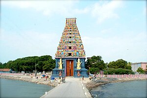
| Nainativu - Gopuram of the Nagapooshani Amman Temple | ||
| Waters | Palk Strait , Indian Ocean | |
| Geographical location | 9 ° 36 '0 " N , 79 ° 46' 5" E | |
|
|
||
| length | 3.5 km | |
| width | 1 km | |
| surface | 3.5 km² | |
| Highest elevation | 7 m | |
| Residents | 3000 857 inhabitants / km² |
|
| main place | Nainativu | |
| Nagapooshani Amman Temple | ||
Nainativu ( Tamil : நயினாதீவு), also known as Manipallavam (Tamil: மணிபல்லவம்) or Nagadipa ( Sinhala : නාගදීපය) is to Sri Lanka belonging island between the south Indian state of Tamil Nadu and the Jaffna peninsula located (Sri Lanka) Palk Strait . It is one of the most important pilgrimage destinations for Hindus and Buddhists from Sri Lanka.
location
Nainativu is located west of the neighboring island of Pungudutivu and northwest of the island of Nedunthivu at a maximum height of 7 m above sea level. d. There are regular ferry connections between the islands. The climate is tropical and warm; Rain falls almost exclusively in the monsoon months from October to December.
population
The Sinhala name Nagadipa seems to allude to the Nagas ("snakes" or "snake worshipers "), which is probably a derogatory characterization of the population. In any case, the north of Sri Lanka has been under Tamil influence for centuries, perhaps even millennia . At an unknown time, the worship of the mother and patron goddess Mariyamman , to whom the island's main temple, built in the 18th century, is dedicated. Of the approximately 3,000 inhabitants, more than 90% are Tamils, i.e. Hindus , and only 5% each are Muslim or Buddhist .
economy
The most important livelihoods of the population are growing vegetables and fishing . In the last decades of the 20th century, tourism was added as a source of income.
history
Greek geographers of the 4th and 3rd centuries BC. BC mention an island called Taprobane ; Claudius Ptolemy locates the island in the south of Asia around 140 AD. In the early and high Middle Ages, the region fell out of view of Europe, which was only to change in the late Middle Ages due to the spice trade dominated by the Muslims . After the Portuguese discovery of the sea route to India , the first maps were made showing Taprobane surrounded by numerous smaller islands, but this does not correspond to reality. Only parts of the former land bridge between India and Ceylon remain as islands. The exact date of the discovery of Nainativus is not known, but a Hindu temple was destroyed by the Portuguese in 1620 .
Attractions
- The island's beaches are barely developed, but there are smaller pensions.
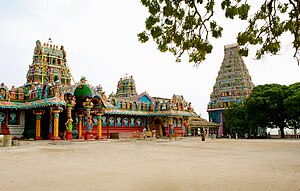
- The brightly painted Nagapooshani Amman Temple , built in the South Indian style, is dedicated to the goddess Mariyamman . It is the destination of many pilgrims on the Jaffna Peninsula and the neighboring islands.
- A temple with an adjacent stupa indicates the long presence of Buddhism in the region.
Web links
- Nainativu - photos, video + information (English)
- Nainativu - Photos and information (English)
- Nainativu - Photos and information (English)


