Nappenplatz (Bad Salzungen)
The Nappenplatz is a public square on the northeast edge of the old town of Bad Salzungen in Thuringia . Today it is used as a parking lot and venue for city festivals.
history
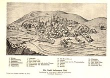
The Nappenplatz is considered the place of origin of the later urban settlement of Bad Salzungen. By the 4th century BC Celts lived on the edge of the Burgsee lake, they were probably the discoverers of a salty spring in the area of today's Nappenplatz and were the first to start producing salt. The Celts were followed by Germanic tribal groups of the Chatti and Hermundurs, later the Franks conquered the Thuringian Kingdom, everyone wanted to own the salty spring, a fortification was built on the edge of the Burgsee - the later Schnepfenburg. The associated place at the salt source already bears the name Salsunga in a Carolingian document - indirect evidence of the continuation of salt production at the source. Around 923 the Hungarians invaded Thuringia and also devastated this settlement of Salzungen during their campaign. According to the Salzung tradition, it took two to three decades to rebuild the settlement and the salt works. In 973 the Salzunger Saline was mentioned in an exchange contract, which was confirmed by the law firm of Emperor Otto II.
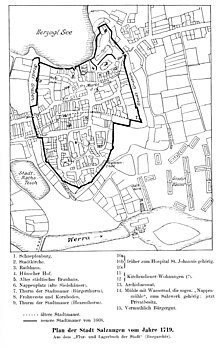
The main source was later called the Stadtborn , it was last secured with an eight-sided wooden crate against groundwater and rainwater and had a depth of 42 Rhenish shoe (?). Around 1137 a second salt spring was discovered at Nappenplatz, which was known as the Unterborn or Niederborn because of its location . From 1150 the salt shops in the saltworks became an important economic asset of the Fulda Monastery , and the Codex Eberhardi assesses the weekly taxes on the salt trade. For the production of the salt, 10 to 12 boiling huts - the so-called "salt naps", were built around the salty spring, where the salty water was evaporated in clay jugs or iron pans. Each boiling hut was maintained by an owner or a group of owners and had to pay a percentage of the amount of salt as a fee, the remaining part belonged to the owner of the boiling hut. Supervision of the salt works was given to the salt counts, deployed officials who had to monitor the daily operations and the salt quality.
The Silge is a natural runoff from the Burgsee and in the Middle Ages it flowed near Nappenplatz to flow into the Werra. A mill built on this stream was now used as a water pump - the technology was probably taken over from mining. The mechanical pumping station now continuously supplied salty water, but the most important raw material for the saltworks became scarce as early as the 14th century - the firewood had to be procured from ever greater distances, and the salt content of both salt springs deteriorated rapidly. In 1552 the new Riemesborn was "excavated" as a second source. In the Salznappen people had long since switched to the use of wrought iron pans, which allow the water to evaporate better, but also caused the salt to become dirty.
The peasants' war only briefly interrupted the saltworks , some of the salt miners expressed their solidarity with the rebels and went to war with the “Black Pile”. After the secularization of the monasteries in Frauensee and Allendorf, the forests of the monasteries became interesting for the salt works, and a wood concession for the forest "Winterkasten" was agreed with the ducal administration. In order to maintain the trade monopoly in the salt trade, attempts are made to prevent the development of further salt pans in the vicinity of the city of Salzungen. In 1541, the Counts of Henneberg wanted to purchase a salt spring "under the Hawenberge" near Immelborn for this purpose.
Around 1570, the salt counts employed proved to be incapable, the technical systems were worn out and the loss of the springs had to be expected as the groundwater level had changed. In 1584 the Riemesborn was redesigned, wooden sheet piling was used to seal the shaft against the groundwater. A vault was also built over the well shaft to keep rainwater out. In 1588 the salt counts ordered the other salt springs to be kept in this way. In 1590 one tried the straw grading for the first time in Salzungen, as early as 1592 the first 9 graduation houses were on the edge of the square. The Haadbrunnen was dug near the Nappenplatz in 1623.
In 1669 the city fortifications were extended to the Nappenplatz and the Silgemühle is now located within the city wall. The ducal “Privilegia, Law, Order and Statuta der Pfännerey zu Salzungen”, written in 1678, is issued. This law again secured the monopoly of the Salzunger Saline, the adjacent offices were only allowed to offer Salzunger Salz on the markets. A city description written in 1717 mentions the city fountain and 12 boiling houses (Nappen) located on Nappenplatz, the Niederborn, the Haadbrunnen (also called "God's gift") on the old Werra, and 12 graduation houses in front of the Nappentor of the city wall (these were in the area from today's train station to the Kurhaus).
Joachim Friedrich von Beust improved the technology of the graduation tower by using black thorn branches. The number of boiling houses could be halved and 17 technically improved graduation towers were built according to Beust's specifications. The economic strength of Salzungen was weakened after the great fire of 1786. The second flowering of the Salzunger Saline began around 1800. By chance they came across another salt spring during construction work and this water was directed to the Gradierplatz in front of the city. Attempts with hard coal firing were given up because fire regulation was not mastered.
Around 1800 only three Nappen remained on Nappenplatz: the men's, the hospital and the Gellmannsnappe .
In 1801 a general from Weimar used the brine water for bathing and thereby alleviated some complaints. 1802 again boiling houses were built on the outskirts at the same time the existing boiling houses on Nappenplatz were demolished except for the Spitalnappe, their owners feared the loss of privileges. In 1821, the well water from Salzung was scientifically examined, and the Pfänkeit agreed to build a bathing establishment. In 1823, 77 spa guests visited the site, and 1,020 bath treatments were administered. Around 1840 a master drill succeeded in drilling a highly concentrated brine layer at a depth of 153 m, making the Salzborn at Nappenplatz superfluous. Today's Nappenplatz was created in 1862 when the previous saltworks buildings were demolished; the necessary new buildings had already been built near the train station. The city left the square undeveloped, lined with acacia trees and allowed the residents to build small gardens and arbors there. The place was also used as a children's playground.
literature
- Cyriacus apple; Justus Valentin Fleischhauer: Haligraphia, or simple and short description of the marvelous Saltzwercks in Saltzungen , Schmalkalden 1674 ( digitized version )
- Rudi Berkes: Bad Salzungen . In: Our little hiking booklet . No. 113 . Brockhaus-Verlag, Leipzig 1965.
- Harry Gerlach: Bad Liebenstein hiking atlas, Bad Salzungen . In: tourist-hiking atlas . tourist Verlag, Berlin, Leipzig 1988, ISBN 3-350-00218-8 , p. 66 .
- Frankensteingemeinde - Association for Salzung History eV 1992 (Ed.): Salzungen. Historical excursion through the Salzunger Land . Bad Salzungen 1992, p. 64 .
- City administration Bad Salzungen (Ed.): Festschrift for the city anniversary of 1225 years Bad Salzungen . Bauer & Malsch-Druck Immelborn, Bad Salzungen 2000, p. 64 .
- Hartmut Ruck et al: Bad Salzungen with a chronological excerpt from the city's history and city center map, important information about the city and company portraits . ETRO-Verlag, Bad Sooden-Saalmünster, p. 72 (without year probably 2000).
- Tobias Günther, Hartmut Ruck: Bad Salzungen . Stadt-Bild-Verlag, Leipzig 2005, ISBN 3-937126-13-9 .
Individual evidence
- ↑ a b c d City administration Bad Salzungen (ed.): Festschrift for the city anniversary of 1225 years Bad Salzungen . Bauer & Malsch-Druck Immelborn, Bad Salzungen 2000, p. 64 .
- ^ Paul Luther: Materials for local history lessons - Bad Salzungen district, Suhl district . Ed .: Council of the Bad Salzungen District, Department of Public Education. Bad Salzungen 1959, The Salzunger "Nappe" through the ages, p. 26-27 .
- ↑ The Herrennappe belonged to the rulers, after its owner also had Walther, the Ottwald-, the Gellmanns- and Schöppennappe named. The stone cap was made of rubble stone, the brick cap was the only one with a roof made of bricks. The middle folder lay between the two . The Hospitalnappe was donated to maintain a St. Johannis Hospital. The Niederbornsnappe was fed with water from the Niederborn. The Neunappen was once a new building, the Gerönnsnappe was probably on one of the wooden feed lines from the main reservoir at the elevator.
Coordinates: 50 ° 48 ′ 51 ″ N , 10 ° 14 ′ 11.2 ″ E


