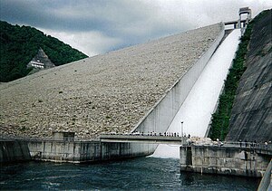
Naramata dam
| Naramata | |||||||
|---|---|---|---|---|---|---|---|
|
|||||||
|
|
|||||||
| Coordinates | 36 ° 52 '57 " N , 139 ° 4' 46" E | ||||||
| Data on the structure | |||||||
| Lock type: | Rockfall dam | ||||||
| Construction time: | 1973-1990 | ||||||
| Height of the barrier structure : | 158 m | ||||||
| Building volume: | 13.1 million m³ | ||||||
| Crown length: | 520 m | ||||||
| Power plant output: | 12.2 MW | ||||||
| Data on the reservoir | |||||||
| Water surface | 2 km² | ||||||
| Storage space | 90 million m³ | ||||||
| Catchment area | 95.4 km² | ||||||
| Design flood : | 1 650 m³ / s | ||||||
The Naramata dam ( Japanese 奈良 俣 ダ ム , ~ damu ) is a dam in the district ( Ōaza ) Fujiwara of Minakami in the Japanese prefecture of Gunma . The barrier structure, a rock embankment dam, is 158 m high and 520 m long.
The Naramata River ( 楢 俣 川 , -gawa ), which is part of the Tone river system , is dammed into a two-square-kilometer reservoir with a capacity of 90 million cubic meters. A hydroelectric power plant with an output of 12.2 MW is operated at the dam .
See also
- List of the largest dams on earth
- List of the largest reservoirs on earth
- List of the largest hydroelectric plants in the world
- List of dams in the world
Web links
Commons : Naramata Dam - Collection of images, videos, and audio files
- Hydroelectric Power Plants in Japan - Gunma , IndustCards, accessed November 2, 2012
- Naramata Dam , accessed November 2, 2012
- Naramata dam. In: Structurae

