Natural realism
Natural realism in cartography is the natural-like representation of the earth's surface using suitable signatures and mainly deals with the representation of vegetation. We know signatures from maps mostly as generalized images of their real equivalents, elevation or supervisory signatures. Despite a wide range of digital possibilities, they are still mainly represented today with the signature treasure known from analog map production.
Very early on one began to create a more realistic representation with painted and later also photographed images. It emerged aerial maps . However, these are only useful on a very large scale.
Since it is becoming more and more difficult for the map user to read classic maps, work is being carried out on generating realistic map signatures. The abstract thinking and the interpretation of extensive legends can largely be omitted here. This makes the maps interesting for a much larger group of users and the time for reading the map can be significantly reduced.
Aerial photos or orthophotos are snapshots and show the surface of the earth at a specific point in time. They contain too high a density of information and can therefore only be used to a limited extent for map displays. A clever signature of the earth's surface is much more suitable.
Methods
Three different generation processes can be distinguished using the forest as an example:
- Suitable objects for the individual signature types are extracted from orthophotos and merged into meaningful structures through duplication. The floor structure is generated separately and placed under all signatures to create a harmonious transition.
- Appropriate views of the respective vegetation are cut out from an orthophoto and improved using image processing to such an extent that the type of signature can be recognized and differentiated very well.
- The signatures are created as vectors. Here it is possible to specifically work out the identifying features, the growth form and the individual types of vegetation.
The signatures from method 1 and 2 would have to be further simplified in order to be immediately recognized and differentiated by the user. In method 1, an exact statement about the tree species is only possible based on the shadow. With method 2, small areas cannot be represented because the individual tree cannot be correctly distinguished. This can be a coniferous, deciduous forest or bush.
In contrast, method 3 creates very abstract signatures. These are much more sensible for a natural realism, since the structures of the individual trees remain recognizable. The appearance of the coniferous forest comes into its own. This is very important because the individual types of vegetation often occur over large areas.
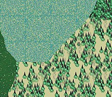
Four different types of vegetation are represented in the following illustration.
Three-dimensional representation
Today representations are already being made in 3D in order to be able to create a much more vivid impression of the terrain. The parallel projection will become more and more important, since the length of the route and the angular dimensions can be estimated right away. Parallel lines are retained in a parallel projection.
swell
Diploma thesis Martin Lässig: Signature of 2D and 3D representations using the example of the Silvretta for screen and print output .

