Ngoma Bridge
Coordinates: 17 ° 55 ′ 17 ″ S , 24 ° 43 ′ 14 ″ E
| Ngoma Bridge | ||
|---|---|---|
| use | Road bridge | |
| Convicted | Chobe | |
| place | Ngoma | |
| construction | steel truss bridge | |
| overall length | 68 m | |
| width | approx. 8 m | |
| Number of openings | 4th | |
| Pillar spacing | 17 m | |
| location | ||
|
|
||
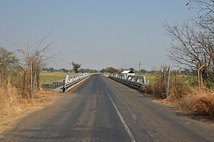
The Ngomabrücke ( English Ngoma Bridge ) forms at Ngoma a border crossing between Namibia and Botswana . It connects the Namibian national road B8 with the A33 Botswana.
It crosses the Chobe , which runs as a small trickle close to the right, eastern bank when the tide is low. The border is accordingly close to the bank and runs in the middle of the bridge. The river, which is about 800 m wide at this point, looks like a wide grassland at this time. At high tide, the river bed is completely flooded. Therefore, on the Namibian side of the bridge, there is a dam across the flat floodplain, which is interrupted about halfway by another bridge.
The 68 m long bridge has four openings, each of which is crossed with a low steel truss construction.
The current bridge and the adjoining road were built on behalf of the Namibian government with funds from KfW in the 2000s.

Web links
Individual evidence
- ↑ See Google Earth, picture taken: 11/20/2014
- ^ Klaus Dierks : Chronology of Namibian History. Entries for 1998. There are also three good photos of the bridge to be seen.

