
National road B8
| National road B8 in Namibia | |||||||||||||||||||||||||||||||||||||||||||||||||||||||||||||||||||||||||||||||

|
|||||||||||||||||||||||||||||||||||||||||||||||||||||||||||||||||||||||||||||||
| map | |||||||||||||||||||||||||||||||||||||||||||||||||||||||||||||||||||||||||||||||
 |
|||||||||||||||||||||||||||||||||||||||||||||||||||||||||||||||||||||||||||||||
| Basic data | |||||||||||||||||||||||||||||||||||||||||||||||||||||||||||||||||||||||||||||||
| Operator: | Roads Authority | ||||||||||||||||||||||||||||||||||||||||||||||||||||||||||||||||||||||||||||||
| Overall length: | 930 km | ||||||||||||||||||||||||||||||||||||||||||||||||||||||||||||||||||||||||||||||
|
Regions : |
|||||||||||||||||||||||||||||||||||||||||||||||||||||||||||||||||||||||||||||||
| Development condition: | Asphalt - two lanes | ||||||||||||||||||||||||||||||||||||||||||||||||||||||||||||||||||||||||||||||
.jpg) |
|||||||||||||||||||||||||||||||||||||||||||||||||||||||||||||||||||||||||||||||
| Bridge of the B8 near Bagani over the Okavango | |||||||||||||||||||||||||||||||||||||||||||||||||||||||||||||||||||||||||||||||
|
Course of the road
|
|||||||||||||||||||||||||||||||||||||||||||||||||||||||||||||||||||||||||||||||
The national road B8 is the most important road from central Namibia to the north-east of the country and the only road connection to the Zambezi region ( Trans-Caprivi Corridor ). The national road begins at Otavi , where it connects to the B1 national road , and leads via Rundu to Katima Mulilo . There the Katima Mulilo Bridge leads to Zambia . The road continues to the southeast to Ngoma , where it ends on the Ngoma Bridge on the border to Botswana .
gallery

the B8 between Rundu and Grootfontein

the B8 in the Caprivi Strip
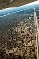
Approach to Mpacha airport ,
B8 on the right side of the picture
the B8 between Katima Mulilo and Ngoma, with a junction to Rundu


See also
Web links
Commons : National Road B8 - Collection of pictures, videos and audio files