Otjozondjupa
|
||||
| Basic data | ||||
|---|---|---|---|---|
| Regional capital | Otjiwarongo | |||
| Biggest town | Otjiwarongo | |||
| motto | Unity, Peace, Development | |||
| ISO 3166-2 | NA-OD | |||
| website | otjozondjuparc.gov.na | |||
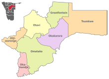
| Map of the region | ||||
| Inhabitants and geography | ||||
| population | 154,342 (2016) | |||
| Population density | 1.47 per km² | |||
| languages | German , Afrikaans , Otjiherero | |||
| Geographic coordinates | 20 ° 24 ′ S , 18 ° 2 ′ E | |||
| surface | 105,327 km² | |||
| The highest point | 2286 meters ( Omatakoberge ) | |||
| Politics and administration | ||||
| Ruling party | SWAPO | |||
| Governor / in | James Uerikua | |||
| Distribution of seats in the regional council | SWAPO 5, NUDO 2 | |||
| Constituencies | 7th | |||
| Last choice | 2015 | |||
| Next choice | 2020 | |||
Otjozondjupa is one of the 14 regions of Namibia . The region is located in the northeast of the republic, in the transition between the drier areas of central Namibia and the tropical areas of the north. The area of the region is 105,328 square kilometers , the population almost 155,000 (as of 2016). The capital and largest town of the region is Otjiwarongo .
In addition to mining , agriculture is the most important industry in the region.
geography
Near the city of Grootfontein is one of the country's most famous sights, the Hoba meteorite , weighing around 50–60 tons . It is considered to be one of the largest meteorites ever found on earth. Its age is estimated to be about 190 to 410 million years; the impact occurred about 80,000 years ago.
population
According to the 2011 census , 27.1 percent of the population of the Otjiherero area speak as their main language. It is followed by Oshivambo with 21.4 percent and Khoekhoegowab with 21.1 percent. 1.3 percent of the population use German as their main language.
politics
The SWAPO , the absolute majority with four of the seven seats.
Administrative division
Otjozondjupa is divided into the following seven constituencies :
There are also (as of June 2018) five local administrations in the region:
- Grootfontein - parish
- Okahandja - parish
- Okakarara - city
- Otavi - city
- Otjiwarongo parish
Regional partnerships
-
 Midlands Province , since February 2020
Web links
- Statistics profile of Otjozondjupa 2011 (PDF); Namibia Statistics Agency , February 2014
Individual evidence
- ↑ Namibia Inter-censal Demographic Survey 2016 Report. (PDF) Namibia Statistics Agency, November 21, 2017.
- ↑ 2011 Population and Housing Census Regional Profile, Otjozondjupa Region. Namibia Statistics Agency, p. 39f. Retrieved June 11, 2020.
- ^ Local Authorities. Otjozondjupa Regional Council; accessed on June 1, 2018.
- ↑ Otjozondjupa Region twins with Mild Province. Informanté, February 27, 2020.


