
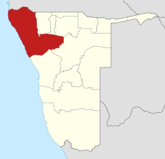
Kunene
|
||||
| Basic data | ||||
|---|---|---|---|---|
| Regional capital | Opuwo | |||
| Biggest town | Outjo | |||
| motto | Unity, Development, Progress | |||
| ISO 3166-2 | NA-KU | |||
| website | www.arc.org.na | |||
| Map of the region | ||||
  |
||||
| Inhabitants and geography | ||||
| population | 97,865 (2016) | |||
| Population density | 0.68 per km² | |||
| languages | Afrikaans , German , Otjiherero , Khoekhoegowab | |||
| Geographic coordinates | 19 ° 34 ′ S , 14 ° 2 ′ E | |||
| surface | 144,254 km² | |||
| The highest point | 2065 meters ( Omavanda ) | |||
| Politics and administration | ||||
| Ruling party | UDF | |||
| Governor / in | Marius Sheya | |||
| Distribution of seats in the regional council | SWAPO 5, DTA 2 | |||
| Constituencies | 7th | |||
| Last choice | 2015 | |||
| Next choice | 2020 | |||


Kunene is the northwesternmost of the 14 regions of Namibia with a large part of the Skeleton Coast and the Namib Desert , and directly adjacent to the province of Cunene in Angola . Both regions get their name from the border river Kunene .
With a population of only 97,865 inhabitants (as of 2016) on an area of 144,254 km², Kunene is one of the least populated regions of Namibia. The region is home to the Himba ethnic group . The capital and administrative center is Opuwo .
geography
The Kunene region comprises large parts of the upper skeleton coast on the South Atlantic to the Kunenedelta and the border with Angola, as well as - following the Namib Desert , which is directly on the coast - large parts of the Kaokoland and Damaraland . Important mountain ranges are the Giraffe Mountains, the Hartmann Mountains , the Jouberts Mountains, the Onjuwa Plain, the Otjihipaberge and the Steilrandberge. To the east, Kunene borders the Etosha National Park .
population
According to the 2011 census , 56.2 percent of the inhabitants of the Otjiherero area speak as their main language. It is followed by Khoekhoegowab with 26.5 percent and Oshivambo with 7.2 percent. 0.4 percent of the population use German as their main language.
politics
Since Namibia's independence, the UDF has provided the relative majority of the Kunene regional council members , who are elected every five years to the regional capital Opuwo. With the 2015 regional council election , SWAPO has the most members for the first time; the UDF, which was previously the strongest force since 1998, is no longer represented in the regional council.
| Political party | 1992-1997 | 1998-2004 | 2004-2010 | 2010-2015 | 2015-2020 |
|---|---|---|---|---|---|
| UDF | 2 | 3 | 3 | 3 | 0 |
| DTA (PDM) | 2 | 2 | 2 | 2 | 2 (1) |
| SWAPO | 1 | 1 | 1 | 1 | 5 |
| RP | 1 | 0 | 0 | 0 | 0 |
| The number of seats can change through by-elections in the course of a legislative period. | |||||
Administrative division
.svg)
Kunene is divided into seven constituencies :
In addition, there are (as of December 2015) four local administrations in the region:
Web links
Individual evidence
- ↑ Namibia Inter-censal Demographic Survey 2016 Report. Namibia Statistics Agency, November 21, 2017.
- ↑ 2011 Population and Housing Census Regional Profile, Kunene Region. Namibia Statistics Agency, p. 38. Retrieved June 10, 2020.
- ↑ Official election result of the regional and local elections 2015, ECN, December 4, 2015 ( Memento of the original of December 10, 2015 in the Internet Archive ) Info: The archive link was inserted automatically and has not yet been checked. Please check the original and archive link according to the instructions and then remove this notice. (PDF; 150 kB)

Epupa | Kamanjab | Khorixas | Opuwo city | Opuwo country | Outjo | Sesfontein