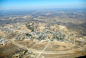
Outjo
| local community Outjo
|
|||
|---|---|---|---|
|
|||
| Aerial view of Outjo (2019) | |||
| motto | Nihil sine deo (Nothing without God) |
||
| Basic data | |||
|
Population Area Population Density |
8400 (2011 census) 104.6 km² 80.3 inh / km² |
||
|
State Region Constituency |
Namibia Kunene Outjo |
||
| Establishment date | May 4, 1898 | ||
|
License plate phone code |
OJ 67 |
||
| Website | outjomun.com.na | ||
|
Political data
Mayor : Samuel! Oe-Amseb ( SWAPO ) Chief Executive Officer : Joseph A. ǀUrib Last election: 2015 Next election: 2020 City Council address: |
|||
|
Geographical data
Geographical coordinates : 20 ° 6′31 "S, 16 ° 9′16" E Height : 1,216 m |
|||
Outjo ( Otjiherero for "small hill") is a municipality in the constituency of the same name in the Kunene region in Namibia . The city has 8400 inhabitants (as of 2011).
Outjo is located on the main road C39 south of the eastern foothills of the Fransfontein Mountains and is divided into the two districts Outjo and Etoshapoort.
The city is considered the cradle of the carnival in Namibia .
history
Since the 16th century, who live in the Kunene region Himba , one of the Herero related Bantu ethnic group . The town of Outjo was founded by German colonial troops on May 4, 1898, after the then Major Theodor Leutwein had set up a military base to explore the still unknown north of German Southwest Africa . Major Victor Franke's expeditions to Ovamboland are shown in the local history museum ( Franke-Haus-Museum ) . The Naulila Memorial commemorates the punitive expedition to the Portuguese fort of Naulila in Angola , which was led by Victor Franke in October 1914. This was carried out after a massacre of a German delegation who wanted to conclude a non-aggression pact.
Local politics
The following official final result was determined in the 2015 local elections .
| Political party | be right | Share of votes | Seats |
|---|---|---|---|
| SWAPO | 1307 | 53.2% | 4th |
| UDF | 706 | 28.7% | 2 |
| DTA | 381 | 15.5% | 1 |
| RDP | 64 | 2.6% | 0 |
| All in all | 2458 | 100% | 7th |
Worth seeing
Outjo offers a few sights, but is above all an important tourist transit point and supply point. In 2006, more than 22,000 tourists per month were counted.
- Franke House Museum
- Naulila Monument
- The water tower , which was originally equipped with a wooden wind turbine, was used to collect water.
Near the city is the finger cliff created by erosion .
Facilities
Outjo had a TransNamib rail connection and airfield ( Outjo airfield ), a hospital and a clinic until the 2000s .
Educational institutions
Immediately in Outjo there are three primary schools and two secondary schools as well as a combined private school with a total of 2634 students and 96 teachers. (As of December 2009)
- Jack Francis Primary School
- Maarssen Primary School
- Outjo Primary School
- Moria Private School
- Etoshapoort Junior Secondary School
- Outjo Secondary School
The following schools are located in the vicinity of the city:
- Otjikondo School Village & Primary School (about 85 kilometers northwest of the city)
- St. Michael Roman-Catholic Primary School (about 70 kilometers northwest of the city)
Town twinning
sons and daughters of the town
- Japie van Zyl (1957–2020), engineer at NASA
Web links
- Official site of the City (English)
- Other official website of the city (English)
- Information about Outjo (English)
- SOMO development aid project Maarssen – Outjo (Dutch)
Individual evidence
- ↑ a b c d Namibia 2011 Population and Housing Census Preliminary Results. Namibia Statistics Agency, April 2012 ( page no longer available , search in web archives ) accessed on May 9, 2012
- ↑ Outjo on a map from the time of German South West Africa
- ↑ Official election results of the regional and local elections 2015, ECN, December 4, 2015 ( Memento of December 10, 2015 in the Internet Archive ) (PDF; 150 kB)
- ↑ Outjo Municipality - Financial and Economic Activities ( Memento from September 6, 2012 in the Internet Archive ) (PDF; 92 kB)
- ↑ Outjo Municipality - School Information ( Memento from March 24, 2014 in the Internet Archive ) (PDF; 127 kB)
- ↑ Archived copy ( Memento from August 19, 2012 in the Internet Archive )
- ↑ http://www.privaatskool-moria.com/
- ↑ Archived copy ( Memento of March 30, 2010 in the Internet Archive )
- ↑ http://www.otjikondo.com/
- ↑ http://www.rcchurch.na/windhoek/schools.htm
Coordinates: 20 ° 7 ′ S , 16 ° 9 ′ E


