
Finger cliff
| Finger cliff | ||
|---|---|---|
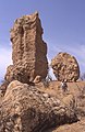
 Fingerklip seen from Vingerklip Lodge (i.e. from the southwest) (2006) |
||
| height | 929 m | |
| location | Kunene , Namibia | |
| Coordinates | 20 ° 22 '58 " S , 15 ° 26' 2" E | |
|
||
| Type | Rock needle | |

The finger cliff (mostly and Afrikaans Vingerklip , rarely English rock finger ) is a rock needle built up from layers of Tertiary sedimentary rock around 80 km southwest of the city of Outjo and around 50 km east of the city of Khorixas in northwest Namibia . The finger cliff is an erosion residue, a kind of miniature witness mountain of a stratified step that extends further east parallel to and north of the Ugab . Like the finger cliff, this layer consists of deposits from the Tertiary forerunners of the Ugab river system and towers over the recent Ugab valley by up to 160 meters. These deposits are predominantly carbonate- bound sandstones and conglomerates .
The tip of the finger cliff is 929 m above sea level, the rock itself is about 35 meters high and has a circumference of 44 meters at its base. In addition to the finger cliff, there are a few other, sometimes significantly larger, erosion remains of this layer level in the area, that is, “real” witness mountains in the form of table mountains .
Since the Mukurob collapsed , the Fingerklippe has been the most famous rock in Namibia.
gallery
View from the northeast (2002)

View from the southeast (2004)
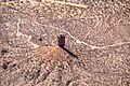
Aerial view from the west (2018)

View from the fingertip to the north

View from the fingertip to the south
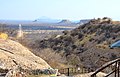
View from the Ugab Terrace Lodge to the south of Fingerklippe and neighboring table mountains


.jpg)
.jpg)
.jpg)

literature
- Gabi Schneider: The roadside geology of Namibia. 2nd Edition. Borntraeger, Stuttgart 2008, ISBN 978-3-443-15084-6 , p. 120.
- Vingerklip & Ugab Terraces. Fact sheet, Geological Survey of Namibia, 2017 ( PDF )