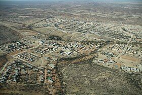
Khorixas
| local community Khorixas Welwitschia (historical)
|
|||
|---|---|---|---|
|
|||
| Khorixas (2018) | |||
| motto | Our town, our pride (Our town, our pride) |
||
| Basic data | |||
|
Population Area Population Density |
6900 (2011 census) 76 km² 90.8 inhabitants / km² |
||
|
State Region Constituency |
Namibia Kunene Khorixas |
||
| Establishment date | |||
|
License plate phone code |
KH 67 |
||
| Website | |||
|
Political data
Mayor : Trypohasa Moloto ( UDF ) Chief Executive Officer : {{{CEO}}} Last election: 2015 Next election: 2020 City administration address: |
|||
|
Geographical data
Geographical coordinates : 20 ° 222′19.63 "S, 14 ° 57′37.48" E Height : 1000 m |
|||
Khorixas is a Namibian municipality in the constituency of the same name in the Kunene region with 6900 inhabitants. The city name means something like "place of the Khori bush".
history
During the time of the South African administration until 1989, the city was the administrative seat of the Homeland Damaraland under the name Welwitschia . The name Welwitschia comes from the Welwitschia plant, which is widespread in parts of Namibia and southern Angola . There is a bank, a hospital, a supermarket and a gas station in the village. There is a connection to the main road C39 and thus to the town of Outjo .
Local politics
The following official final result was determined in the 2015 local elections .
| Political party | be right | Share of votes | Seats |
|---|---|---|---|
| SWAPO | 1741 | 54.9% | 4th |
| UDF | 1345 | 42.4% | 3 |
| DTA | 71 | 2.2% | 0 |
| RDP | 15th | 0.5% | 0 |
| All in all | 3172 | 100% | 7th |
Educational institutions
Elementary schools
- A. Gariseb Primary School
- Eddie Bowe Primary School
- Elias Amxab Primary School
- Frans Frederick Primary School
- Jakob Basson Primary School
- Th F. Gaeb Junior Primary School
- Versteende Woud Sen Prim. School
- Warmquelle Primary School
High schools
- Braunfels Agricultural High School
- Cornelius Goreseb Sen. Sec. School
- Welwitschia Junior Sec. School
Touristic

For tourist visitors, Khorixas is - apart from the supply options - especially important because of its proximity to the organ pipes , the Petrified Forest , the Burnt Mountain and the rock engravings of Twyfelfontein (the latter three are national monuments in Namibia ). On the outskirts of Khorixas there are simple overnight camps and, since 2000, an overnight lodge in the center of the village. To the northeast of Khorixas are the village of Fransfontein and the rock needle of the Fingerklippe .
Khorixas has a 2 km long airfield east of the city, which runs parallel to the main C39 road .
Web links
Individual evidence
- ↑ a b c d Namibia 2011 Population and Housing Census Preliminary Results. Namibia Statistics Agency, April 2012 ( page no longer available , search in web archives ) Info: The link was automatically marked as defective. Please check the link according to the instructions and then remove this notice. Retrieved May 9, 2012
- ↑ Official election result of the regional and local elections 2015, ECN, December 4, 2015 ( Memento of the original of December 10, 2015 in the Internet Archive ) Info: The archive link was inserted automatically and has not yet been checked. Please check the original and archive link according to the instructions and then remove this notice. (PDF; 150 kB)
- ↑ http://www.namibiaurlaub.com/damaraland_namibia_unterkunft.html
Coordinates: 20 ° 22 ′ S , 14 ° 58 ′ E


