List of constituencies in Namibia
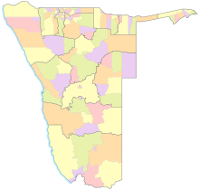
Namibia consists of 14 regions in which there are a total of 121 constituencies (up to August 8, 2013 13 regions and 107 constituencies). Each county has a county administrative seat.
These are important for general voter registration and regional council elections . In the context of the National Assembly election and the presidential election , every registered voter can cast their votes in any constituency and does not have to do so in their home constituency.
The constituencies are divided according to size and number of inhabitants. Changes to these constituencies - and regions - can only be made by the Delimitation Commission of Namibia . In each constituency, a representative for is Regional (regional council) elected. According to the proposal of the 4th Demarcation Commission , in 2013 President Pohamba divided the Kavango region into Kavango East , which takes the region number from Kavango, and Kavango West , which is listed as the new region number 14.
The population is based on the last census in 2011 .
Erongo
| Constituency | Code (according to ISO 3166-2: NA ) |
Area (in km²) |
Residents | Inhabitants (per km²) |
District administrative seat |
|---|---|---|---|---|---|
| Arandis | NA.ER.AR | 13,490 | 9,898 | 0.7 | Arandis |
| Durations | NA.ER.DA | 17,752 | 11,162 | 0.6 | Uis |
| Caribib | NA.ER.KA | 14,521 | 12,785 | 0.9 | Caribib |
| Omaruru | NA.ER.OM | 8,425 | 8,325 | 1.0 | Omaruru |
| Swakopmund | NA.ER.SW | 196 | 43,846 | 223.7 | Swakopmund |
| Walvis Bay Land | NA.ER.WR | 9.134 | 26,489 | 2.9 | Kuisebmund |
| Walvis Bay town | NA.ER.WU | 19th | 33,283 | 1,751.7 | Walvis Bay |
| total | NA.ER | 63,719 | 150,809 | 2.7 | Swakopmund |
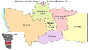
Hardap
| Constituency | Code (according to ISO 3166-2: NA ) |
Area (in km²) |
Residents | Inhabitants (per km²) |
District administrative seat |
|---|---|---|---|---|---|
| Aranos | NA.HA.AR | 8,528 | Aranos | ||
| Daweb | NA.HA.DW | 5,768 | Malta height | ||
| Gibeon | NA.HA.GI | 6.354 | Gibeon | ||
| Mariental-Land | NA.HA.MR | 6,780 | Stampriet | ||
| Mariental city | NA.HA.MU | 5,919 | 15,300 | 2.6 | Mariental |
| Rehoboth Land | NA.HA.RR | 10,954 | 7,300 | Slip | |
| Rehoboth City (East) | NA.HA.RE | 283 | 18,600 | Rehoboth | |
| Rehoboth City (West) | NA.HA.RW | 327 | 11,200 | 34.3 | Rehoboth |
| total | NA.HA | 109,781 | 79,000 | 0.6 | Mariental |
ǁKaras (formerly Karas)
| Constituency | Code (according to ISO 3166-2: NA ) |
Area (in km²) |
Residents | Inhabitants (per km²) |
District administrative seat |
|---|---|---|---|---|---|
| Berseba | NA.KA.BE | 31,744 | 10,589 | 0.3 | Berseba |
| Karasburg East | NA.KA.KA | 9,203 | Karasburg | ||
| Karasburg-West | NA.KA.KW | 7,267 | Noordoewer | ||
| Keetmanshoop Land | NA.KA.KR | 37,999 | 7,219 | 0.2 | Little crown |
| Keetmanshoop town | NA.KA.KU | 525 | 19,447 | 37.0 | Keetmanshoop |
| ǃNamiǂNûs | NA.KA.LU | 48,225 | 13,859 | 0.3 | Luderitz |
| Oranjemund | NA.KA.OR | 4,623 | 9,837 | 2.1 | Oranjemund |
| total | NA.KA | 161,514 | 77,421 | 0.5 | Keetmanshoop |
Kavango East
| Constituency | Code (according to ISO 3166-2: NA ) |
Area (in km²) |
Residents | Inhabitants (per km²) |
District administrative seat |
|---|---|---|---|---|---|
| Mashare | NA.KE.MA | 9,175 | 15,688 | 1.7 | Mashare |
| Mukwe | NA.KE.MU | 5,571 | 27,690 | 5.0 | Mukwe |
| Ndiyona | NA.KE.ND | 9,551 | Ndiyona | ||
| Ndonga Linena | NA.KE.NL | 11,082 | Ndonga Linena | ||
| Rundu country | NA.KE.RE | 9,381 | Rundu | ||
| Rundu city | NA.KE.RU | 2,098 | 63,431 | 9.9 | Rundu |
| total | NA.KE | 136,823 | Rundu |
Kavango West
| Constituency | Code (according to ISO 3166-2: NA ) |
Area (in km²) |
Residents | Inhabitants (per km²) |
District administrative seat |
|---|---|---|---|---|---|
| Kapako | NA.KW.KP | 6,205 | 27,000 | 4.3 | Kapako |
| Mankumpi | NA.KW.MK | 4,464 | Satotwa | ||
| Mpungu | NA.KW.MP | 8,234 | 20,700 | 2.5 | Mpungu |
| Musese | NA.KW.MS | 10,011 | Rupara | ||
| Ncamagoro | NA.KW.NG | 7,043 | Ncamagoro | ||
| Ncuncuni | NA.KW.NC | 8,541 | Ncaute | ||
| Nkurenkuru | NA.KW.NK | 7,064 | Nkurenkuru | ||
| Tondoro | NA.KW.TO | 14,029 | Kahenge | ||
| total | NA.KW | 107.905 | Nkurenkuru |
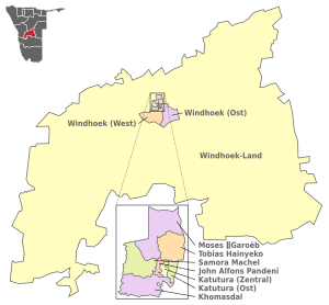
Khomas
| Constituency | Code (according to ISO 3166-2: NA ) |
Area (in km²) |
Residents | Inhabitants (per km²) |
District administrative seat |
|---|---|---|---|---|---|
| Katutura central | NA.KH.KC | 2 | 24,608 | 12,304 | Single quarters |
| Katutura East | NA.KH.KE | 3 | 21,564 | 7,188 | Donkerhoek |
| Khomasdal | NA.KH.KN | 26th | 35,832 | 1,378 | Otjomuise |
| Moses Garoëb | 33 | 45,564 | 1,381 | Havana | |
| Samora Machel | 19th | 49.178 | 2,588 | Wanaheda | |
|
John Alfons Pandeni (until October 31, 2012: Soweto) |
NA.KH.SO | 2 | 15.121 | 7,560 | Soweto |
| Tobias Hainyeko | 19th | 45,912 | 2,416 | Ombili | |
| Windhoek country | NA.KH.WR | 36,469 | 19,143 | 0.5 | Groot Aub |
| Windhoek East | NA.KH.WE | 167 | 25,823 | 155 | Little Windhoek |
| Windhoek West | NA.KH.WW | 209 | 53,438 | 256 | Windhoek West |
| total | NA.KH | 36,964 | 342.141 | 9.3 | Windhoek |
Kunene
| Constituency | Code (according to ISO 3166-2: NA ) |
Area (in km²) |
Residents | Inhabitants (per km²) |
District administrative seat |
|---|---|---|---|---|---|
| Epupa | NA.KU.EP | 23,518 | 17,696 | 0.8 | Epupa |
| Kamanjab | NA.KU.KA | 17,105 | 8,441 | 0.5 | Kamanjab |
| Khorixas | NA.KU.KH | 21,269 | 12,566 | 0.6 | Khorixas |
| Opuwo city | NA.KU.OB | 12,910 | Opuwo | ||
| Opuwo land | NA.KU.OR | 14,362 | Otuani | ||
| Outjo | NA.KU.OU | 7,464 | 12,447 | 1.7 | Outjo |
| Sesfontein | NA.KU.SE | 20.181 | 8,434 | 0.4 | Sesfontein |
| total | NA.KU | 115.260 | 86,856 | 0.8 | Opuwo |
Grandmaheke
| Constituency | Code (according to ISO 3166-2: NA ) |
Area (in km²) |
Residents | Inhabitants (per km²) |
District administrative seat |
|---|---|---|---|---|---|
| Aminuis | NA.OH.AM | 13,028 | 12.306 | 0.9 | Aminuis |
| Epukiro | NA.OH.EP | 17,495 | 6.106 | 0.3 | Epukiro |
| Gobabis | NA.OH.GO | 10,959 | 21,000 | 1.9 | Gobabis |
| Kalahari | NA.OH.KA | 5,781 | 7,500 | 1.3 | Buitepos (Tsaka) |
| Otjinene | NA.OH.ON | 12,283 | 7,306 | 0.6 | Otjinene |
| Otjombine | NA.OH.OB | 6,435 | 6,851 | 1.1 | Talismanus |
| Okorukambe | NA.OH.ST | 19,000 | 10,060 | 0.6 | Witvlei |
| total | NA.OH | 84,981 | 70,800 | 0.8 | Gobabis |
Ohangwena
| Constituency | Code (according to ISO 3166-2: NA ) |
Area (in km²) |
Residents | Inhabitants (per km²) |
District administrative seat |
|---|---|---|---|---|---|
| Eenhana | NA.OW.EE | 1,111 | 12,987 | 11 | Eenhana |
| Endola | NA.OW.ED | 328 | 25,500 | 77.7 | Endola |
| Engela | NA.OW.EG | 296 | 24,300 | 82.0 | Engela |
| Epembe | NA.OH.EP | 1,810 | 16,200 | 8.9 | Epembe |
| Ohangwena | NA.OW.OH | 170 | 17,500 | 102.4 | Ohangwena |
| Okongo | NA.OW.OK | 4,697 | 25,600 | 5.4 | Okongo |
| Omundaungilo | NA.OW.OM | 597 | 7,800 | 13.1 | Omundaungilo |
| Omulonga | NA.OW.OL | 261 | 32,500 | 124.3 | Onamukulo |
| Ondobe | NA.OW.OD | 618 | 24,000 | 38.8 | Ondobe |
| Ongenga | NA.OW.OG | 498 | 21,900 | 43.8 | Ongenga |
| Oshikango | NA.OW.OS | 320 | 28,700 | 89.8 | Oshikango |
| Oshikunde | NA.OW.OI | 12,987 | Omutvewomunu | ||
| total | NA.OW | 10,706 | 245,100 | 22.9 | Eenhana |
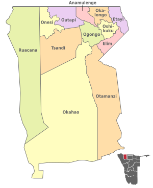
Omusati
| Constituency | Code (according to ISO 3166-2: NA ) |
Area (in km²) |
Residents | Inhabitants (per km²) |
District administrative seat |
|---|---|---|---|---|---|
| Anamulenge | NA.OS.AN | 353 | 14,949 | 42.3 | Anamulenge |
| Elim | NA.OS.EL | 444 | 12.199 | 27.5 | Elim |
| Etayi | NA.OS.ET | 643 | 30,550 | 47.5 | Etayi |
| Ogongo | NA.OS.OG | 805 | 16,436 | 20.4 | Ogongo |
| Okahao | NA.OS.OH | 9,890 | 18,734 | 1.9 | Okahao |
| Okalongo | NA.OS.OL | 656 | 26,459 | 40.3 | Okalongo |
| Onesi | NA.OS.ON | 601 | 16,613 | 27.6 | Onesi |
| Oshikuku | NA.OS.OS | 277 | 14,699 | 53.1 | Oshikuku |
| Outapi | NA.OS.OU | 4.178 | 36,740 | 8.8 | Outapi |
| Otamanzi | NA.OS.OT | 2,358 | 13,495 | 5.7 | Omatanzi |
| Ruacana | NA.OS.RA | 983 | 14,857 | 15.1 | Ruacana |
| Tsandi | NA.OS.TS | 5,363 | 27,435 | 5.1 | Tsandi |
| total | NA.OS | 6,551 | 243.166 | 9.2 | Outapi |
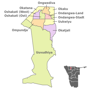
Oshana
| Constituency | Code (according to ISO 3166-2: NA ) |
Area (in km²) |
Residents | Inhabitants (per km²) |
District administrative seat |
|---|---|---|---|---|---|
| Okaku | NA.ON.OK | 224 | 18,900 | 84.3 | Okaku |
| Okatana | NA.ON.OT | 425 | 14,700 | 34.6 | Okatana |
| Okatyali | NA.ON.OJ | 557 | 3,200 | 5.7 | Okatyali |
| Ompundja | NA.ON.OM | 465 | 4,600 | 10.0 | Ompundja |
| Ondangwa land | NA.ON.OR | 13,613 | Eheke | ||
| Ondangwa town | NA.ON.OU | 23,233 | Ondangwa | ||
| Ongwediva | NA.ON.OG | 221 | 27,396 | 124.0 | Ongwediva |
| Oshakati East | NA.ON.OE | 187 | 27,227 | 145.6 | Omeege |
| Oshakati West | NA.ON.OW | 240 | 20,676 | 86.2 | Oshakati |
| Uukwiyu | NA.ON.UK | 299 | 12,100 | 40.6 | Uukwiyu |
| Uuvudhiya | NA.ON.UV | 5,819 | 4,000 | 0.7 | Uuvudhiya |
| total | NA.ON | 8,647 | 174,900 | 20.3 | Oshakati |
Oshikoto
| Constituency | Code (according to ISO 3166-2: NA ) |
Area (in km²) |
Residents | Inhabitants (per km²) |
District administrative seat |
|---|---|---|---|---|---|
| Eengodi | NA.OT.EE | 7,816 | 15,490 | 2.8 | Eengodi |
| Guinas | NA.OT.GU | 10,239 | 5,460 | 1.0 | Tsintsabis (Guinas) |
| Nehale IyaMpingana | NA.OT.NL | 10,710 | Okoloti | ||
| Okankolo | NA.OT.OO | 3,554 | 13.204 | 4.5 | Okankolo |
| Olukonda | NA.OT.OL | 241 | 9,600 | 39.6 | Olukonda |
| Omuntele | NA.OT.OT | 1,629 | 17,100 | 10.5 | Omuntele |
| Omuthiyagwiipundi | NA.OT.OG | 13,389 | 26,100 | 2.0 | Omuthiyagwiipundi |
| Onayena | NA.OT.ON | 442 | 15,400 | 34.7 | Onayena |
| Oniipa | NA.OT.OP | 372 | 24,800 | 66.8 | Oniipa |
| Onyaanya | NA.OT.OY | 731 | 20,800 | 28.5 | Onyaanya |
| Tsumeb | NA.OT.TS | 271 | 19,700 | 22.7 | Tsumeb |
| total | NA.OT | 38,685 | 181,600 | 4.7 | Omuthiya |
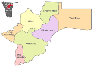
Otjozondjupa
| Constituency | Code (according to ISO 3166-2: NA ) |
Area (in km²) |
Residents | Inhabitants (per km²) |
District administrative seat |
|---|---|---|---|---|---|
| Grootfontein | NA.OD.GR | 11,300 | 24,600 | 2.2 | Grootfontein |
| Okahandja | NA.OD.OD | 5,856 | 24,300 | 4.1 | Okahandja |
| Okakarara | NA.OD.OR | 14,669 | 22,500 | 1.5 | Okakarara |
| Omatako | NA.OD.OM | 24,893 | 17,300 | 0.7 | Okandjira (Omatako) |
| Otavi | NA.OD.OV | 14,243 | 12,488 | 0.9 | Otavi |
| Otjiwarongo | NA.OD.OW | 5,903 | 31,813 | 5.4 | Otjiwarongo |
| Tsumkwe | NA.OD.TS | 28,590 | 9,900 | 0.3 | Tsumkwe |
| total | NA.OD | 105,460 | 142,400 | 1.4 | Otjiwarongo |
Zambezi (formerly Caprivi)
| Constituency | Code (according to ISO 3166-2: NA ) |
Area (in km²) |
Residents | Inhabitants (per km²) |
District administrative seat |
|---|---|---|---|---|---|
| Judea Lyaboloma | NA.CA.JL | 1,703 | 5.511 | 3.3 | Sangwali |
| Kabbe North | NA.CA.KN | 1,164 | 9,559 | 8.2 | Kabbe |
| Kabbe south | NA.CA.KS | 1,236 | 8,073 | 6.5 | Nakabolelwa |
| Katima Mulilo-Land | NA.CA.KR | 1,595 | 13,285 | 8.3 | Katima Mulilo |
| Katima Mulilo city | NA.CA.KU | 32 | 28,362 | 868.3 | Katima Mulilo |
| Kongola | NA.CA.KO | 5.117 | 7,366 | 1.4 | Kongola |
| Linyanti | NA.CA.LI | 1,781 | 7,328 | 4.1 | Linyanti |
| Sibbinda | NA.CA.SI | 1,831 | 11,112 | 6.1 | Sibbinda |
| total | NA.CA | 14,785 | 90,596 | 6.1 | Katima Mulilo |
See also
Web links
- Population and Housing Census, 2011. (English)
Individual evidence
- ↑ a b In Government Gazette 5261 GG 1 (Aug. 9, 2013) Retrieved April 13, 2017
- ^ Media Briefing at State House by President Pohamba. Namibia Press Agency (Nampa), August 8, 2013
- ↑ No. 5481. Government Gazette of the Republic of Namibia, June 9, 2014.
- ↑ Election commission on constituencies and electoral procedures ( memento of the original from October 12, 2009 in the Internet Archive ) Info: The archive link has been inserted automatically and has not yet been checked. Please check the original and archive link according to the instructions and then remove this notice.
- ↑ Article 103 & Article 104. Constitution of Namibia, NSHR ( Memento of the original from June 3, 2012 in the Internet Archive ) Info: The archive link has been inserted automatically and has not yet been checked. Please check the original and archive link according to the instructions and then remove this notice. Retrieved June 22, 2012
- ↑ http://www.citypopulation.de/Namibia_d.html
- ↑ a b c d e f g h i j k l m n Namibia 2011 Population and Housing Census Preliminery Results. Namibia Statistics Agency, April 2012 ( page no longer available , search in web archives ) Info: The link was automatically marked as defective. Please check the link according to the instructions and then remove this notice. Retrieved May 9, 2012
- ↑ No longer Soweto. The Namibia, November 2, 2012
