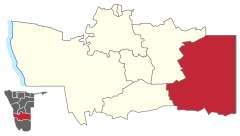
Aranos (constituency)
 Details |
Aranos constituency |
| Basic data | |
|---|---|
|
State region |
Namibia Hardap |
|
Population area District administrative seat |
8528 Aranos |
| Election information | |
|
Registered voters |
|
The constituency of Aranos has been a Namibian constituency in the east of the Hardap region since August 9, 2013 . The district administrative seat and namesake of the constituency is the city of Aranos . The constituency is bordered by the Mariental Land and Gibeon constituencies to the west and Botswana to the east . The constituency has 8,528 inhabitants (as of 2011).
See also
Individual evidence
- ^ Namibia 2011 Population and Housing Census Preliminery Results. Namibia Statistics Agency, April 2012 ( page no longer available , search in web archives ) Info: The link was automatically marked as defective. Please check the link according to the instructions and then remove this notice. Retrieved May 9, 2012
Coordinates: 25 ° 26 ′ S , 19 ° 11 ′ E


