Kongola (constituency)
 Details |
Kongola constituency |
| Basic data | |
|---|---|
|
State region |
Namibia Zambezi (region) |
|
Population area District administrative seat |
7366 5123 Kongola |
| Election information | |
|
Registered voters |
|
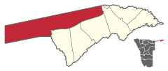
Kongola is the westernmost and largest constituency in terms of area of the eight constituencies of the Zambezi region in Namibia . The administrative seat is the town of the same name Kongola . The district has 7366 inhabitants (as of 2011).
The constituency of Kongola includes the settlements of Mwanzi , Izwi , Mulanga , Pipo , Munguza , Kahunikwa , Poca , Queensland , Kakuwa , Mitondo , Nxtohei and Kachenje .
Councilor of the constituency is David Muluti from SWAPO , who won 1262 votes in the 2010 regional council elections and thus received 66.39% of all votes.
Individual evidence
- ↑ - ( Memento from August 4, 2015 in the Internet Archive )
- ↑ 2011 Population and Housing Census, Zambezi Regional Tables based on the 4th Delimitation. Namibia Statistics Agency, 2014, p. 3ff ( Memento from February 24, 2015 in the Internet Archive ) accessed on February 24, 2015
- ^ Electoral Commission of Namibia: Presidential and National Assembly Elections 2009, Polling Stations. Supplement to several Namibian newspapers, November 10, 2009
- ↑ Uitslae bly instroom, Die Republikein, November 28, 2010
Coordinates: 17 ° 58 ′ S , 23 ° 17 ′ E

