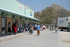
Katima Mulilo
| City & constituency Katima Mulilo
|
|||
|---|---|---|---|
|
|||
| Shopping center in Katima Mulilo | |||
| motto | Unity is Power (unit power) |
||
| Basic data | |||
|
Population Area Population Density |
28,362 ( 2011 census ) |
||
|
State Region Constituency |
Namibia Zambezi Katima Mulilo city |
||
| Establishment date |
1911 1992 as a city |
||
|
License plate phone code |
KM 66 |
||
| Website | www.kmtc.org.na | ||
|
Political data
Mayor : Georgina Mwiya-Simataa ( SWAPO ) Chief Executive Officer : Vincent Sazita ( currently suspended ) Last election: 2015 Next election: 2020 City administration address: |
|||
|
Geographical data
Geographical coordinates : 17 ° 30 'S, 24 ° 16' E |
|||
Katima Mulilo ( SiLozi for extinguishing the fire ) is a city, constituency ( Katima Mulilo Stadt , English Katima Mulilo Urban ) and capital of the Zambezi region (formerly Caprivi ) in the extreme northeast of Namibia . The city is located on the south bank of the Zambezi River , here the border river to Sesheke , Zambia, on the north side of the river . Katima Mulilo has 28,362 inhabitants.
history
As a result of the Heligoland-Sansibar Treaty , the Caprivi Strip became part of what was then German Southwest Africa on July 1, 1890, and thus the most distant part of present-day Namibia from the capital Windhoek . Katima Mulilo was founded in 1911 and took over the administrative headquarters for the Caprivi in 1935, as it was higher than the Luhonono (formerly Schuckmannsburg ) founded in 1909 and not so exposed to the seasonal floods of the Zambezi. Due to the impassable marshland between Okavango and Cuando , the Caprivi Strip could not be crossed by land until the 1940s and so Katima Mulilo, 1,230 km away from Windhoek, could only be reached via the Bechuanaland or Northern Rhodesia . Although the Caprivi Strip was already better connected to the land by a gravel road to Rundu at the time of Namibia's independence , weather conditions, involvement in the civil war in Angola (1975 to 2002) and independence struggles in Caprivi only made the Eastern Caprivi into the 21st century achievable with effort.
This has changed the long term since the beginning of the 21st century: Angola is pacified and the weather-related difficulties were the construction of the Trans-Caprivi Highway ( Trans Caprivi Highway ), one of Walvis Bay through the Caprivi and Zambia to the Democratic Republic of the Congo further asphalt trunk road to be cleared. The keystone of this mammoth project, which was largely financed by Germany and the EU, was the opening of the Katima-Mulilo Bridge in 2004 with a border crossing to Sesheke in Zambia, on the other side of the river .
Katima Mulilo has the airport Katima Mulilo (Mpacha) with scheduled flights.
Todays situation
The appearance of Katima Mulilo is in many ways more "African" than other places in Namibia, where you can still feel the influence of the German colonial era . The city has a modern infrastructure such as schools, hospitals, supermarkets and petrol stations. Wild elephants live in the vicinity of Katima Mulilo, and the regular floods of the Zambezi mean that in addition to the resulting destruction, crocodiles also reach the city limits.
Katima Mulilo is also located in a relatively restless environment, as the colonial borders to Botswana, Zambia and Zimbabwe were drawn without regard to settlement areas and the needs of the tribes living there. This repeatedly resulted in border disputes or even armed conflicts, most recently in 1999 in Katima Mulilo by a secession movement that connected the Zambezi region to Botswana , but was also supported by Angola and Zambia.
In the meantime, however, the situation has calmed down and the Zambezi region is experiencing an economic upswing, which is being largely supported by increasing tourism. Katima Mulilo also plays a part in this and is particularly benefiting from the decline in tourism on the Zimbabwean side, as many groups of visitors to the nearby Victoria Falls prefer the crime-free accommodations on the Namibian side.
Local politics
The following official final result was determined in the 2015 local elections .
| Political party | be right | Share of votes | Seats |
|---|---|---|---|
| SWAPO | 1875 | 83.8% | 6th |
| DTA | 163 | 7.3% | 1 |
| RDP | 82 | 3.7% | 0 |
| Katima Alliance Development Association | 52 | 2.3% | 0 |
| APP | 33 | 1.5% | 0 |
| NDP | 33 | 1.5% | 0 |
| All in all | 2238 | 100% | 7th |
Educational institutions
Elementary schools
|
|
Further training
|
|
Further educational institutions
- Zambezi Vocational School
- Caprivi College of Education
Town twinning
|
Web links
- Official Website of the City (English)
Individual evidence
- ↑ a b Namibia 2011 Population and Housing Census Report. Namibia Statistics Agency 2012 ( memento of October 2, 2013 in the Internet Archive ) accessed on May 9, 2012
- ↑ http://www.klausdierks.com/Geschichte/index_founding_of_towns.htm
- ↑ Katima CEO and finance chief suspended again . The Namibian, July 25, 2011 ( Memento from September 6, 2012 in the web archive archive.today )
- ^ History of Katima Mulilo. Katima Mulilo Town Council ( September 29, 2013 memento in the Internet Archive ). Retrieved February 28, 2013
- ↑ http://www.klausdierks.com/Geschichte/89.htm
- ↑ Official election results of the regional and local elections 2015, ECN, December 4, 2015 ( Memento of December 10, 2015 in the Internet Archive ) (PDF; 150 kB)
- ↑ http://www.rcchurch.na/rundu/schools/mulumba.htm
- ↑ http://www.rcchurch.na/rundu/schools/kizito.htm
- ↑ Katima Mulilo and Windhoek city sign agreement. Namibia Press Agency, 23 August 2017.
Coordinates: 17 ° 30 ′ S , 24 ° 17 ′ E


