Otjiwarongo
| local community Otjiwarongo
|
|||
|---|---|---|---|
|
|||
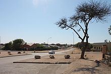
| Otjiwarongo city center | |||
| motto | Gradatim (step by step) |
||
| Basic data | |||
|
Population Area Population Density |
28,000 (2011 census) 139.9 km² 200.2 inhabitants / km² |
||
|
State Region Constituency |
Namibia Otjozondjupa Otjiwarongo |
||
| Establishment date | 1892 | ||
|
License plate phone code |
OT 67 |
||
| Website | otjimun.org.na | ||
|
Political data
Mayor : Bennes Haimbondi Chief Executive Officer : Moderatha Shaduka Last election: 2015 Next election: 2020 City Council address: |
|||
|
Geographical data
Geographical coordinates : 20 ° 27 ′ 51 ″ S, 16 ° 39 ′ 10 ″ E Height : 1460 m |
|||
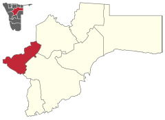
Otjiwarongo ( Herero for "beautiful place for the fat cattle") is the administrative seat and capital of the Otjozondjupa region ( Namibia ) and the district town of the constituency of the same name . The city has 28,000 inhabitants.
It is centrally located on the B1 between the north Namibian maize triangle ( Otavi , Tsumeb , Grootfontein ) and the capital Windhoek, 250 kilometers to the south . This makes Otjiwarongo easy to reach and accordingly has functions as a city and especially as a center for the agricultural surrounding area, which includes the places Kalkfeld and Okakarara . The Waterberg massif lies around 50 kilometers southeast of the city ; 70 kilometers south of Mount Etjo .
history
Otjiwarongo was founded in 1892 as one of the first places in South West Africa . In 1900 the first German settlers moved to the place previously inhabited only by Herero and a few Damara , where the Herero and Nama uprising began in 1904 . In 1906 Julius Doll opened the first shop in Otjiwarongo.
On April 2, 1906, the place was connected to the Otavibahn . The old steam locomotive “No. 41 ”, which was built in 1912 by the Henschel company in Kassel , which is why it is now often called the“ old Henschel locomotive ”. It was once used on the railway line between Swakopmund and Otavi .
The town, which had grown considerably due to its central location, was granted town charter in 1939.
Population and languages
90% of the population should speak and understand Afrikaans . About 75% speak English and about 35% German . However, indigenous languages such as Otjiherero , Khoekhoegowab and Oshivambo are predominant .
Local politics
The following official final result was determined in the 2015 local elections .
| Political party | be right | Share of votes | Seats |
|---|---|---|---|
| SWAPO | 3901 | 70.6% | 5 |
| DTA | 454 | 8.2% | 1 |
| UDF | 442 | 8.0% | 1 |
| NUDO | 298 | 5.4% | 0 |
| Association of Otjiwarongo Residents | 238 | 4.3% | 0 |
| APP | 141 | 2.6% | 0 |
| RDP | 50 | 0.9% | 0 |
| All in all | 5524 | 100% | 7th |
economy
In 2008, in the “International UN Year for Basic Sanitation”, the local Clay House Project (CHP) started a new project together with the German development organization SODI : Dry toilets , now over 600, also known as Otji toilets , were found in the settlement areas the city of Otjiwarongo and other parts of the country. The aim is to prevent infectious diseases such as diarrhea and cholera, which are one of the greatest threats to the health and life of children and adults, in the future.
On July 2, 2015, the local electricity supplier Cenored agreed a power purchase agreement with HopSol Power Generation . It secures the purchase of energy from the HopSol solar park Otjiwarongo , the construction of which was completed in November 2015. The 5 MW - photovoltaic Plant was built near Otjiwarongo and to produce from 2016 some 13.5 million kWh per year.
The Whale Rock cement factory started operations in October 2018 .
education
- Karundu Primary School
- Orwetoveni Primary School
- Otjiwarongo Primary School
- Rogate Primary School
- Spes Bona Primary School
- Vooruit Primary School
- TrainOccasion Primary School
- Donatus School Otjiwarongo (from 1966-1995: German School Otjiwarongo)
- Edugate Academy Private School
- Monica Geingo's Secondary School
- Otjiwarongo Secondary School
- Paresis Secondary School
- Perivoli Okonjima Country School (near Otjiwarongo)
- (German) private school Otjiwarongo (since 2000)
- Tsaraxa-Aibes Combined School
Attractions
- ETANENO is anart museum and studio builtby Erwin Gebert and Alfonso Hüppi in1999,50 km south of Otjiwarongo.
- The city is home to two institutions that are committed to protecting African big cats: the AfriCat Foundation and the Cheetah Conservation Fund .
- The oldest crocodile farm in Namibia is located on the eastern outskirts of Otjiwarongo .
- A narrow-gauge locomotive is well worth seeing in front of the station (see the history section ).
- The Waterberg Plateau Park is located about 50 kilometers southeast of the city.
Sports
The main local football clubs are Mighty Gunners and Life Fighters , whose home stadium is Mokati Stadium .
Town twinning
Source:
sons and daughters of the town
- Niel Barnard (* 1949), South African intelligence chief
- Dan Craven (* 1983), Namibian racing cyclist
- Hage Geingob (* 1941), Namibian politician, first Prime Minister and third President of Namibia
- Michaela Hübschle (* 1950), Namibian politician
- Vekuii Rukoro (* 1954), traditional leader of the Herero
- Agnes Samaria (* 1972), middle distance runner
- Calle Schlettwein (* 1954), Namibian politician
Web links
- Official website of the City (English)
- Unofficial city portal (English)
Individual evidence
- ↑ a b c d Namibia 2011 Population and Housing Census Preliminary Results. National Planning Commission, April 2012 , accessed May 9, 2019
- ^ Otjiwarongo town council re-elects Bennes Haimbondi as mayor. NBC, December 2, 2017
- ↑ Otjiwarongo on a map from the time of German South West Africa
- ↑ See also: main regional languages in Namibia, according to the 2001 census.
- ↑ Result of the regional and local elections 2015, ECN, December 4, 2015 (PDF; 150 kB)
- ^ Website of the Otji Toilets
- ↑ Allgemeine Zeitung, July 10, 2015
- ↑ HopSol project page , accessed on November 25, 2016
- ↑ Whale Rock Cement workers claim exploitation . Lela Mobile Online , accessed June 7, 2019
- ↑ Homepage TrainOccasion Primary School , accessed on December 4, 2016
- ↑ http://www.edugate.org.na
- ↑ http://otjisec.webs.com/
- ↑ http://www.perivoliokonjimacountryschool.org
- ↑ http://www.dsvo.org
- ↑ Life Fighters promoted to Premier League. The Namibian, March 13, 2016.
- ↑ Otjiwarongo connected with Kgatleng. Allgemeine Zeitung, October 25, 2011
Coordinates: 20 ° 28 ′ S , 16 ° 39 ′ E


