
National road B1
| National road B1 in Namibia | |||||||||||||||||||||||||||||||||||||||||||||||||||||||||||||||||||||||||||||||||||||||||||||||||||||||||||||||||||||||||||||||||||||||||||||||||||||||||||||||||||||||||||||||||||||||||||||||||||||||||||||

|
|||||||||||||||||||||||||||||||||||||||||||||||||||||||||||||||||||||||||||||||||||||||||||||||||||||||||||||||||||||||||||||||||||||||||||||||||||||||||||||||||||||||||||||||||||||||||||||||||||||||||||||
| |
|||||||||||||||||||||||||||||||||||||||||||||||||||||||||||||||||||||||||||||||||||||||||||||||||||||||||||||||||||||||||||||||||||||||||||||||||||||||||||||||||||||||||||||||||||||||||||||||||||||||||||||
| map | |||||||||||||||||||||||||||||||||||||||||||||||||||||||||||||||||||||||||||||||||||||||||||||||||||||||||||||||||||||||||||||||||||||||||||||||||||||||||||||||||||||||||||||||||||||||||||||||||||||||||||||
 |
|||||||||||||||||||||||||||||||||||||||||||||||||||||||||||||||||||||||||||||||||||||||||||||||||||||||||||||||||||||||||||||||||||||||||||||||||||||||||||||||||||||||||||||||||||||||||||||||||||||||||||||
| Basic data | |||||||||||||||||||||||||||||||||||||||||||||||||||||||||||||||||||||||||||||||||||||||||||||||||||||||||||||||||||||||||||||||||||||||||||||||||||||||||||||||||||||||||||||||||||||||||||||||||||||||||||||
| Operator: | Roads Authority | ||||||||||||||||||||||||||||||||||||||||||||||||||||||||||||||||||||||||||||||||||||||||||||||||||||||||||||||||||||||||||||||||||||||||||||||||||||||||||||||||||||||||||||||||||||||||||||||||||||||||||||
| Overall length: | 1515 km | ||||||||||||||||||||||||||||||||||||||||||||||||||||||||||||||||||||||||||||||||||||||||||||||||||||||||||||||||||||||||||||||||||||||||||||||||||||||||||||||||||||||||||||||||||||||||||||||||||||||||||||
| of which in operation: | 1515 km | ||||||||||||||||||||||||||||||||||||||||||||||||||||||||||||||||||||||||||||||||||||||||||||||||||||||||||||||||||||||||||||||||||||||||||||||||||||||||||||||||||||||||||||||||||||||||||||||||||||||||||||
|
Regions : |
|||||||||||||||||||||||||||||||||||||||||||||||||||||||||||||||||||||||||||||||||||||||||||||||||||||||||||||||||||||||||||||||||||||||||||||||||||||||||||||||||||||||||||||||||||||||||||||||||||||||||||||
| Development condition: | Asphalt - two lanes, partly in the 2 + 1 system | ||||||||||||||||||||||||||||||||||||||||||||||||||||||||||||||||||||||||||||||||||||||||||||||||||||||||||||||||||||||||||||||||||||||||||||||||||||||||||||||||||||||||||||||||||||||||||||||||||||||||||||
.jpg) |
|||||||||||||||||||||||||||||||||||||||||||||||||||||||||||||||||||||||||||||||||||||||||||||||||||||||||||||||||||||||||||||||||||||||||||||||||||||||||||||||||||||||||||||||||||||||||||||||||||||||||||||
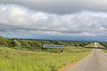
| The B1 national road south of Keetmanshoop | |||||||||||||||||||||||||||||||||||||||||||||||||||||||||||||||||||||||||||||||||||||||||||||||||||||||||||||||||||||||||||||||||||||||||||||||||||||||||||||||||||||||||||||||||||||||||||||||||||||||||||||
|
Course of the road
|
|||||||||||||||||||||||||||||||||||||||||||||||||||||||||||||||||||||||||||||||||||||||||||||||||||||||||||||||||||||||||||||||||||||||||||||||||||||||||||||||||||||||||||||||||||||||||||||||||||||||||||||
The Namibian national road B1 is the most important north-south connection in Namibia and crosses the entire country from the border to Angola near Oshikango in the north, to the border to South Africa near Noordoewer in the south. Due to the central route, the longest national road in Namibia forms the main connection of the country and is the starting point for numerous main traffic routes in west-east direction. The national road B1 is a section of the Trans-African Highway No. 3 , which leads from Tripoli via Windhoek to Cape Town, as well as a section of the SADC highways Trans-Kalahari , Walvis Bay-Ndola-Lubumbashi and Trans-Cunene .
course
The national road B1 begins on the border with Angola near Oshikango, with the transition from the Angolan EN120 to the national road. It runs through the cities of Ondangwa , Tsumeb , Otavi and Otjiwarongo . After passing through Okahandja , the B1 ends about 15 kilometers south of the village (as of October 2019) with the transition to the A1 motorway . In the Hochlandpark district of the capital Windhoek , the further route of the national road B1 begins with the renewed transition from the A1 motorway. The cities of Rehoboth , Mariental and Keetmanshoop follow in the further course of the route . In the south on the border with South Africa near Noordoewer , after crossing seven Namibian regions and over 1500 km, the B1 national road ends and merges into the N7 .
Road conditions
The entire length of the B1 national road has been developed as a two-lane asphalt trunk road. Some parts of the B1 are laid out in the 2 + 1 system . These tracks are referred to as so-called English climbing lanes and are increasingly found on the section between Windhoek and Rehoboth.
Future development
As a further four-lane expansion of the national road B1 to the A1 motorway is in planning and construction, the route length will gradually decrease in the coming years. Plans call for a further expansion to a motorway from Okahandja to Rehoboth, 160 km away. In addition, there are plans to convert the B1 national road into a motorway on an 80 km long section between Ondangwa and Omuthiya (with an upstream expansion of the C46 from Ongwediva to Ondangwa).
Picture gallery

70 km north of Keetmanshoop

Karas Mountains near Narubis

Between Windhoek and Rehoboth

At the Tropic of Capricorn
Reference to Otjiwarongo County


