Keetmanshoop
| local community Keetmanshoop Nu-gouses ( naq )
|
|||
|---|---|---|---|
|
|||
| Keetmanshoop from a bird's eye view (2017) | |||
| motto | Laborando vincimus (win with work) |
||
| Basic data | |||
|
Population Area Population Density |
18,900 (2011 census) 586.9 km² 32.2 inhabitants / km² |
||
|
State Region Constituency |
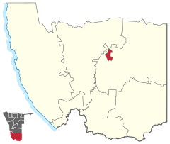
Namibia ǁKaras Keetmanshoop City |
||
| Establishment date | April 14, 1866 | ||
|
License plate phone code |
K 63 |
||
| Website | keetmanshoopmunicipality.org.na | ||
|
Political data
Mayor : Moses Nicky Titus Chief Executive Officer : Paul Vleermuis Last election: 2015 Next election: 2020 City administration address: |
|||
|
Geographical data
Geographic coordinates : 26 ° 34′S, 18 ° 8′E Height : 1,000 m |
|||
Keetmanshoop ( ) is the regional capital of the ǁKaras region in southern Namibia and is located about 500 kilometers south of the capital Windhoek . The place was named after the German merchant and banker Johann Keetman ("hoop" means "hope" in Afrikaans ) and today - together with its suburb Krönlein - has 18,900 inhabitants.
geography
Keetmanshoop is located in the center of southern Namibia and in the western foothills of the Kalahari basin. Around 30 kilometers west of the city run the Bogu Mountains, which are part of the Great Edge Step and through whose hilly landscape the Fish River also runs. It has been dammed by the Neckartal dam since 2018 . The eastern outskirts of the city are largely flat, with only a few mountain ranges such as the Düseldorn (1116 meters) or the Grauer Kuppe (1022 meters).
To the northeast of the city are the quiver tree forest and the giant playground .
City structure
Keetmanshoop is divided into different districts , including among others
- Krönlein (east of the B1 national road )
- Noordhoek (north of the railway line)
- Tseiblaagt, also recently Hendrik Tseib (south of Krönlein)
- Westende (center of the city)
climate
Like much of southern Namibia, Keetmanshoop has an arid climate with little rainfall.
| Keetmanshoop | ||||||||||||||||||||||||||||||||||||||||||||||||
|---|---|---|---|---|---|---|---|---|---|---|---|---|---|---|---|---|---|---|---|---|---|---|---|---|---|---|---|---|---|---|---|---|---|---|---|---|---|---|---|---|---|---|---|---|---|---|---|---|
| Climate diagram | ||||||||||||||||||||||||||||||||||||||||||||||||
| ||||||||||||||||||||||||||||||||||||||||||||||||
|
Average monthly temperatures and rainfall for Keetmanshoop
Source: wetterkontor.de
|
|||||||||||||||||||||||||||||||||||||||||||||||||||||||||||||||||||||||||||||||||||||||||||||||||||||||||||||||||||||||||||||||||||||||||||||||||||||||||||||||||||||
history

The origins of the city go back to a settlement by a Nama tribe at the end of the 18th century. This had separated from the main tribe based in Hoachanas (the "Red Nation") and moved to a new pasture area on the banks of the Swartmodder under its leader Tseib (hence also called "Tseib'scher Tribe") - then called "Modderfontein". The actual place Keetmanshoop was only founded in 1866 as a station of the Rhenish Mission . It was named after the German industrialist Johann Keetman, who provided the mission with the necessary financial means, but never visited the site himself. Thanks to his support, the mission station gradually grew into a German settlement: the missionary Tobias Fenchel had the first school built in 1888. In 1894 a military post was stationed in Keetmanshoop under Lieutenant Bethe. The latter began in the same year with the construction of a fort for the German "Schutztruppen" , which was completed in 1898. Later it had to give way to the local police station.

From 1895 the stone church designed by Wilhelm Sander was built. With his financial commitment, Keetman combined the hope (hence the Afrikaans name "Keetmanshoop") to be able to achieve pacification by Christianizing the warring tribes resident in Namaland.
During the 1960s, according to the South African apartheid policy , residential areas were created for the different ethnic groups of the city, which were strictly separated from one another and some of them are shaped in this way to this day. The residential area TseiblaAGEN was named after the local captain Henderik Tseib . Krönlein, on the other hand, bears the name of an early German missionary who was active in the area.
In 1994 the former Apostolic Vicariate Keetmanshoop was elevated to the Diocese of Keetmanshoop with the Cathedral of St. Stanislaus .
politics
Municipal council
The following official final result was determined in the 2015 local elections .
| Political party | be right | Share of votes | Seats |
|---|---|---|---|
| SWAPO | 2337 | 71.1% | 5 |
| DTA | 538 | 16.4% | 1 |
| RDP | 186 | 5.7% | 1 |
| RP | 141 | 4.3% | 0 |
| DPN | 52 | 1.6% | 0 |
| WRP | 35 | 1.1% | 0 |
| All in all | 3289 | 100.00% | 7th |
Economy and Transport


Keetmanshoop was already an important stop for traders from the Cape Province heading north when it was founded. Today's national road B1 between Vioolsdrift and Windhoek builds on this track. In 1908 the existing Windhoek – Keetmanshoop railway was extended by the Lüderitz Railway to Lüderitz on the Atlantic . This gave Keetmanshoop a rail connection to the Atlantic and the port of Lüderitz . It was not until much later that today's B4 national road was built through the diamond restricted area to the coast. Today the city is the most important junction for road and rail traffic in southern Namibia and the Republic of South Africa and, with Keetmanshoop Airport, it is also a local air traffic hub.
Keetmanshoop is the economic and administrative center of the Karas region in southern Namibia and is therefore also called the capital of the south. The main industries are tourism and the breeding of Karakul sheep . Further agricultural use is not possible in this region due to the arid climate; Keetmanshoop is located on the edge of both the southern winter rain area and the northern summer rain area, which means that the place and region often receive no rainfall at all for years. On a long-term average, only 100–200 millimeters of rain fall here annually, so that the place’s drinking water supply can only be ensured through the “ Naute Dam ”, about 50 kilometers away .
Culture and sights

Some buildings from the time of German colonial rule still exist as evidence of the founding history of Keetmanshoop : The church of the Rhenish Mission , built in granite by missionary Tobias Fenchel in 1895 , now houses a local history museum, which provides a detailed overview of the city's history.
The Imperial Post Office from 1910 now houses the city's tourist information center. The station building from 1908 has also been preserved. The J. Stephanus Stadium is a sports facility.
Attractions
The quiver tree forests ( Afrikaans : Kokerboom Woud ) to the northeast of Keetmanshoop are a special tourist attraction . These groups of trees of the Aloe dichotoma , mostly located on private farms, have been under nature protection since 1955 . The name refers to the texture of the wood. Since this is easy to hollow out, the people of the San and Khoi Khoi made quivers for their hunting arrows from the branches of this tree.
Furthermore, about 40 km northeast of Keetmanshoop is the Mesosaurus Fossil Bush Camp , from which geological, scenic and historical features of the area can be visited.
Town twinning
Educational institutions
The following schools exist in Keetmanshoop:
- Keetmanshoop Primary School
- Krönlein Primary School
- St. Matthias Primary School ( RKK Namibia )
- Don Bosco Catholic Primary School (RKK Namibia)
- M. Sachs Primary School
- Keetmanshoop Secondary School
- Suiderlig Secondary School
- PK de Villiers Secondary School
- JA Nel Secondary School
A new campus of the University of Namibia has been under construction in the city since 2013 .
sons and daughters of the town
- Zenatha Coleman (* 1993), Namibian soccer player
- Lorraine Jossob (* 1993), Namibian national soccer player
- Jackson Kaujeua (1953-2010), Namibian musician
- Ingeborg Körner (* 1929), German actress
- Hellmut von Leipzig (1921-2016), German soldier
- Gerhard Sandner (1929–2013), German geographer and university professor
- Hans-Günther Toetemeyer (1930-2017), German politician (SPD), Member of the Bundestag, Member of the Bundestag
- Virgil Vries (* 1991), Namibian football player
literature
- Johannes Paul : Germans, Boers and English in South West Africa. Accompanying word to a map of nationalities of Europeans in South West Africa. In: "Koloniale Rundschau" issue 9/10, 1931.
Web links
- Official website (English)
Individual evidence
- ↑ a b c d Namibia 2011 Population and Housing Census Preliminary Results. Namibia Statistics Agency, April 2012 ( page no longer available , search in web archives ) Info: The link was automatically marked as defective. Please check the link according to the instructions and then remove this notice. Retrieved May 9, 2012.
- ↑ Keetmandhoop on a map from the time of German South West Africa
- ↑ a b Keetmanshoop Municipality: Keetmanshoop -Memory Lane ( page no longer available , search in web archives ) Info: The link was automatically marked as defective. Please check the link according to the instructions and then remove this notice. Retrieved November 9, 2012
- ↑ Official election result of the regional and local elections 2015, ECN, December 4, 2015 ( Memento of the original of December 10, 2015 in the Internet Archive ) Info: The archive link was inserted automatically and has not yet been checked. Please check the original and archive link according to the instructions and then remove this notice. (PDF; 150 kB)
- ^ A b North-South Local Government Cooperation Program. Embassy of Finland ( Memento of the original from November 11, 2013 in the Internet Archive ) Info: The archive link has been inserted automatically and has not yet been checked. Please check the original and archive link according to the instructions and then remove this notice. Retrieved March 25, 2013
- ^ Keetmanshoop and Upington municipalities sign MoU. Namibia Press Agency, September 7, 2018.
- ↑ Karas School Map, Raison.com.na ( Memento of the original from November 23, 2011 in the Internet Archive ) Info: The archive link was inserted automatically and has not yet been checked. Please check the original and archive link according to the instructions and then remove this notice. Retrieved July 24, 2011
Coordinates: 26 ° 35 ′ S , 18 ° 8 ′ E


