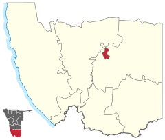
Keetmanshoop town
 Details |
Constituency Keetmanshoop Town Keetmanshoop Urban |
| Basic data | |
|---|---|
|
State region |
Namibia ǁKaras |
|
Population area District administrative seat |
18,900 525 Keetmanshoop |
| Election information | |
|
Registered voters |
|
Keetmanshoop-Stadt ( English Keetmanshoop Urban ) is a constituency in the ǁKaras region in southern Namibia .
The constituency Keetmanshoop-Stadt has a total population of 18,900 inhabitants (as of 2011) and largely corresponds to the city of the same name Keetmanshoop , with the exception of the district Krönlein , which belongs to the surrounding constituency Keetmanshoop Land (English Keetmanshoop Rural ).
Individual evidence
- ↑ Namibia 2011 Population and Housing Census Preliminary Results. National Planning Commission, 2012, pp. 41/42.
Coordinates: 26 ° 34 ′ S , 18 ° 9 ′ E


