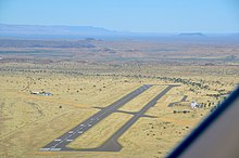
Keetmanshoop Airport
| Keetmanshoop Airport | |
|---|---|

|
|
| Characteristics | |
| ICAO code | FYKT |
| IATA code | KMP |
| Coordinates | |
| Height above MSL | 1069 m (3507 ft ) |
| Transport links | |
| Distance from the city center | 5 km north of Keetmanshoop |
| Street |
|
| Basic data | |
| operator | Namibia Airports Company |
| Terminals | 1 |
| Passengers | 959 (2019) |
| Flight movements |
643 (2019) |
| Runways | |
| 04/22 | 2316 m × 45 m asphalt |
| 18/36 | 1434 m × 30 m gravel (asphalt) |
The Keetmanshoop Airport ( english Keetmanshoop Airport ; also Keetmanshoop JGH van der Wath Airport ) is the airport of the community Keetmanshoop in Namibia . The airport is located around five kilometers north of the city on the B1 national road and has a 2316 meter long main runway and an almost 1500 meter long replacement runway .
The airfield is the location of the Namibian Air Force and the Namibian Aviation Training Academy (NATA).
It is the largest airport in the country that is not used for scheduled flights and is operated by the state-owned Namibia Airports Company .
statistics
| 2008 | 2009 | 2010 | 2011 | 2012 | 2013 | 2014 | 2015 | 2016 | 2017 | 2018 | 2019 | |
|---|---|---|---|---|---|---|---|---|---|---|---|---|
| Flight movements | 1401 | 800 | 736 | 1246 | 899 | 942 | 937 | 967 | 993 | ? | 618 | 643 |
| Passengers | 1370 | 1582 | 1530 | 2178 | 1980 | 2311 | 2287 | 2260 | 2479 | ? | 1188 | 953 |
Source: Airport Statistics. Namibia Airports Company, January 2020.
Web links
Commons : Keetmanshoop Airport - collection of images, videos and audio files
- NAC, Keetmanshoop Airport (English)
- Keetmanshoop Airport aeronautical chart on SkyVector.com
Individual evidence
- ↑ About Us. NATA. Retrieved June 26, 2020.
