
Oranje (river)
|
Orange Orange |
||
 Catchment area of the orange |
||
| Data | ||
| location |
Southern Africa (from top to bottom): Lesotho South Africa Namibia |
|
| River system | Orange | |
| source | as Senqu in Lesotho in the Drakensberg 28 ° 53 ′ 48 ″ S , 29 ° 1 ′ 5 ″ E |
|
| Source height | 3150 m | |
| muzzle |
Atlantic coordinates: 28 ° 37 ′ 51 ″ S , 16 ° 27 ′ 0 ″ E 28 ° 37 ′ 51 ″ S , 16 ° 27 ′ 0 ″ E |
|
| Mouth height | 0 m | |
| Height difference | 3150 m | |
| Bottom slope | 1.5 ‰ | |
| length | 2160 km (with Vaal around 2360 km) | |
| Catchment area | 973,000 km² | |
| Drain |
MQ |
370 m³ / s |
| Right tributaries | Malibamatšo , Senqunyane , Makhaleng , Caledon , Vaal , Fish River | |
 NASA satellite photo of Oranjemund estuary (April 11, 2001) |
||
 Orbit image from the ISS of the lower reaches with the confluence in the Atlantic Ocean (March 20, 2020) |
||
The Oranje ( English Orange ) is 2160 kilometers after the Zambezi, the second longest river in southern Africa . It flows through Lesotho and South Africa . According to the Heligoland-Zanzibar Treaty , the north bank forms the border between South Africa and Namibia on its lower reaches . In contrast, Article 1, paragraph 4 of the Namibian constitution describes the middle of the river as a state border, which South Africa does not recognize.
In Lesotho the river is called Senqu [ ˈsɛ / ᵑǃu ], in South Africa also Gariep , in Namibia Orange ; The English term orange is also sometimes used in atlases .
River course
The Oranje rises as Senqu in the highlands of Lesotho and flows from there through the plateau landscapes of the Drakensberg in a westerly direction through South Africa. After emerging from the hill country about halfway along its course, it joins the Vaal , by far its largest tributary , which is about 200 kilometers longer than the main river , which is often called the Upper Orange . However, the water flow of the Vaal is only around 57% of the Oranje. Shortly before reaching the border with Namibia, the Orange River has dug itself deep into the rock and forms the famous Augrabies Falls, the center of the Augrabies National Park, near the town of Upington . It is then followed by the border between Namibia and the Republic of South Africa for over 500 kilometers . At the same time it crosses the ǀAi-ǀAis Richtersveld Transfrontier Park . At Oranjemund the Oranje flows into the Atlantic Ocean , where it forms a lagoon-like estuary that represents a " Ramsar area ".
The Oranje has been transporting large quantities of sand from the interior to the estuary in the South Atlantic since prehistoric times. There, the sand is driven to the Namibian coast by the Benguela Current and the constant southwest wind and becomes the starting point for the formation of the dunes in the Namib . This is why the Orange is known as the "father of the Namib".
Tributaries
- Kraai River
- Caledon
- Vaal
- Fish river (drying bed)
- Molopo
Economical meaning
The river is the basis for extensive irrigated agriculture in both South Africa and Namibia. Especially for the wine-growing , but also for fishing , the supply of Greater Johannesburg with drinking water , and for some controversial projects for power generation it is of great importance. A tributary of the Orange River feeds the Katse Dam in Lesotho, the Orange River itself feeds the largest reservoir in South Africa, the Gariep Reservoir . Due to the intensive use of the water, its current flow of around 175 m³ / s is only around 47% of the natural runoff. The Oranje is not navigable, but because of its slow current it is used for tourist canoe and rubber boat trips.
On the lower reaches of the river, in the valley widening around Vioolsdrift , very small water management buildings by the farmers developed into an irrigation area after 1945. This region is one of the very dry and driest areas in South Africa.
For millions of years, diamonds from the region around the South African Kimberley were also carried into the ocean, from where they were washed north to the dunes of the Namib by the ocean currents. This area, to which Oranjemund also belongs, is therefore now a large diamond restricted area .
Historical meaning
Together with the Vaal, the Orange formed the external borders of the independent Boer Republic of Orange Free State . These Boer possessions were guaranteed by the British in the Sand River Convention in 1852 ; they lasted until the Peace of Vereeniging in 1902, which ended the Second Boer War .
gallery
The sequence of images shows the course of the river in the direction of flow from the Lesotho Highlands to its mouth.
As Senqu River near Masitise in Quthing District ( Lesotho )

General Hertzog Bridge at Aliwal North

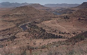
River at Prieska

Rocky gorge with tributary not far from the Augrabies Falls

River on the border of South Africa and Namibia near Vioolsdrift

The course of the river south of Rosh Pinah

The course of the river in the ǀAi-ǀAis Richtersveld Transfrontier Park at Sendelingsdrift

Vegetation of Sarcocornia pillansii in the estuary delta near Alexander Bay (view to Namibia)


_(26442090647).jpg)
_(36752529984).jpg)
literature
- Thomas Kruchem: Orange ~ Senqu. Artery of Life . German Society for International Cooperation, Verlag Brandes and Apel, Frankfurt am Main 2012, ISBN 978-3-86099-884-7 .
See also
Web links
- Website for Orange in South Africa (English)
Individual evidence
- ↑ Article 3 of the Recognition of the Independence of Namibia Act, 1990
- ^ Review of Surface Hydrology in the Orange River Catchment . (English, PDF; 463 kB), 2007
- ↑ Traugott Molter: Water balance and irrigation agriculture in the Cape . Franz Steiner Verlag , Wiesbaden 1966, pp. 105, 152
- ^ South African Weather Service: Climate Vioolsdrif . on www.weathersa.co.za (PDF, English)
Remarks
- ↑ A comparison measurement in aerial photographs (google earth, 2011) showed around 2,450 km.
- ↑ Note: This article contains characters from the alphabet of the Khoisan languages spoken in southern Africa . The display contains characters of the click letters ǀ , ǁ , ǂ and ǃ . For more information on the pronunciation of long or nasal vowels or certain clicks , see e.g. B. under Khoekhoegowab .