National Route 7
| National Route N7 in South Africa | |||||||||||||||||||||||||||||||||||||||||||||||||

|
|||||||||||||||||||||||||||||||||||||||||||||||||
| |
|||||||||||||||||||||||||||||||||||||||||||||||||
| map | |||||||||||||||||||||||||||||||||||||||||||||||||
| Basic data | |||||||||||||||||||||||||||||||||||||||||||||||||
| Operator: | South African National Roads Agency | ||||||||||||||||||||||||||||||||||||||||||||||||
| Start of the street: |
Cape Town ( 33 ° 53 ′ S , 18 ° 32 ′ E ) |
||||||||||||||||||||||||||||||||||||||||||||||||
| End of street: |
Vioolsdrift ( 28 ° 46 ′ S , 17 ° 38 ′ E ) |
||||||||||||||||||||||||||||||||||||||||||||||||
| Overall length: | 666 km | ||||||||||||||||||||||||||||||||||||||||||||||||
| N7 north of Vanrhynsdorp | |||||||||||||||||||||||||||||||||||||||||||||||||
|
Course of the road
|
|||||||||||||||||||||||||||||||||||||||||||||||||
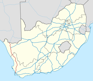
The National Route 7 (short N7 ) is a national road in South Africa , the Cape Town with Vioolsdrift on the border with Namibia joins. On the Namibian side, the name changes to B1 . The road continues to Windhoek and northern Namibia. The entire route is part of the Trans-African Highway Tripoli-Cape Town .
Route
The N7 is a four-lane motorway from the urban area of Cape Town to the north of the city limits . In the further course it is two-lane.
The national road N7 begins at a junction with the N1 and the M7 in the Summer Greens district . The M7, which is approaching as Vanguard Drive , merges into the N7 at this generously developed intersection. From the outskirts of the metropolitan municipality of City of Cape Town , it runs in a long arc, past Morningstar Airfield , in a north-easterly direction to Malmesbury . It is partially accompanied by a railway line that comes from the direction of Bellville . The R315 branches off south of Malmesbury towards the Atlantic coast . North of the city, the road runs largely parallel to this railway past Moorreesburg to the edge of Piketberg . There is a small domestic airport here. A few kilometers north, at Pools , the railway line crosses the road and runs further west at a greater distance. Shortly before Citrusdal , the N7 reaches the valley level of the Olifants River , the course of which it follows downstream and to the left via Clanwilliam with another regional airport.
It changes sides of the valley between the small towns of Trawal and Klawer and leaves the valley in a north-easterly direction at the latter. At Vanrhynsdorp , the place is equipped with a small regional airport, it crosses the R27 and swings in a long arc to the northwest, touches the village Nuwerus and after 16 kilometers reaches Bitterfontein . Here the previously parallel railway line approaches the N7 again, but ends in this small town. Shortly after Bitterfontein, the R358 branches off to the right, which leads over the Bokkeveld Mountains into the interior of the country.
With the crossing of the river Groen , she leaves the territory of the Western Cape Province . Now the N7 passes through a scarcely populated area in the province of Northern Cape , while the settlements Garies , Karkams , Kamieskroon and Mesklip touched and finally the place Springbok reached. The R355 leads here from the south-east through a sparsely populated area. Another regional road runs to the west and reaches the village of Kleinzee near the Atlantic coast. From Springbok it is only a few kilometers to Okiep , in the vicinity of which there are now abandoned mines that were once very rich in copper ore mining . About 44 kilometers north of Okiep the R382 branches off in Steinkopf , which creates a road connection to South Africa's northernmost port in Port Nolloth and from there to Alexander Bay not far from the mouth of the Oranje . The N7 continues north from Steinkopf and reaches Vioolsdrift . Here she crosses the Orange Valley and leaves South Africa in the direction of Namibia. The town of Noordoewer is on the Namibian side .

