National Route 3
| National Route N3 in South Africa | |||||||||||||||||||||||||||||||||||||||||||||||||||||||||||||||||||||||||

|
|||||||||||||||||||||||||||||||||||||||||||||||||||||||||||||||||||||||||
| map | |||||||||||||||||||||||||||||||||||||||||||||||||||||||||||||||||||||||||
| Basic data | |||||||||||||||||||||||||||||||||||||||||||||||||||||||||||||||||||||||||
| Operator: | South African National Roads Agency | ||||||||||||||||||||||||||||||||||||||||||||||||||||||||||||||||||||||||
| Start of the street: |
Durban ( 29 ° 51 ′ S , 31 ° 1 ′ E ) |
||||||||||||||||||||||||||||||||||||||||||||||||||||||||||||||||||||||||
| End of street: |
Johannesburg ( 26 ° 3 ′ S , 28 ° 5 ′ E ) |
||||||||||||||||||||||||||||||||||||||||||||||||||||||||||||||||||||||||
| Overall length: | 579 km | ||||||||||||||||||||||||||||||||||||||||||||||||||||||||||||||||||||||||
|
Course of the road
|
|||||||||||||||||||||||||||||||||||||||||||||||||||||||||||||||||||||||||
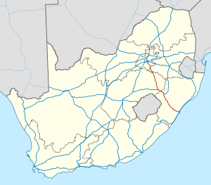
The National Route 3 (short- N3 ) is a national road in South Africa , the Johannesburg and Durban connects. Johannesburg is the financial and economic center of South Africa, while Durban is South Africa's most important port and one of the largest in the southern hemisphere and also a holiday destination. Most of the exports and imports of goods from Johannesburg are handled through the port in Durban . Because of this, the N3 is a very busy road and has a lot of traffic, although the distance is almost 600 kilometers.
Route sections

The N3 is divided into twelve sections, starting with section 1 in Durban and ending with section 12 in Johannesburg. The cities of Heidelberg , Villiers , Warden , Harrismith , Van Reenen , Ladysmith , Estcourt , Mooi River , Howick and Pietermaritzburg are on the route . Most of these cities are now bypassed on bypasses.
In Johannesburg, the road officially begins at the Buccleuch Junction, the point where the N3, N1 and M1 meet. It leads east past Johannesburg as part of the N3 Eastern Bypass and then continues towards Heidelberg. The N3 leads further south on another bypass around Harrismith in the foothills of the Drakensberg . From here the road drops sharply and leads over the Van Reenen Pass into the hilly landscape of the KwaZulu-Natal Midlands .
The N3 then crosses a grassy landscape around the Mooi River, which is used for dairy farming, and passes the Midmar Reservoir near Howick. At Pietermaritzburg the road falls sharply again and leads around Town Hill . From here the road runs on a straight 80 kilometers towards the coast of the Indian Ocean, past the outskirts of Pinetown and Westville , to Durban. At its end, the N3 leads into the Durban Central Business District ( Durban CBD ) with access to the port of Durban and forms the connection to the N2 on the Durban Outer Ring Road .
Alternative route
At the points where the N3 was relocated, the old route has been renamed R103 . The R103 is available in three places:
- between Durban and Ladysmith,
- between Warden and Villiers and
- between Heidelberg and Johannesburg.
In general, the R103 is used to avoid the tollbooths on the N3; however, there is one exception, the Tugela East Toll Plaza , which is on the R103 at the intersection of the two streets north of Ladysmith.
Within Durban, most of the old N3 has been renamed M13 instead of the usual R103. The R103 branches off the M13 at the suburb of Winston Park .
Planned route modifications
There are plans to relocate the section between the Tugela toll booth and the start of the toll section near Warden. This would mean that the new road would lead over the De Beers Pass and no longer over Van Reenen. This would shorten the N3 by 14 kilometers. However, the population of Harrismith and Van Reenen is very much against it, as they depend on through traffic for their jobs. The fact that the gradient is too steep for a national road speaks in favor of the new route.
According to the calculations of the N3 Toll Concession , the new bypass will only be required when the traffic volume of 13,900 vehicles per day is reached - currently the traffic volume is 11,000 vehicles per day. According to projections, this will be the case in 2014.
Web links
- South African National Roads Agency Ltd. (SANRAL) . on www.nra.co.za (English)
- SANRAL: Road Conditions N3 . on www.nra.co.za (English)
Individual evidence
- ↑ N3 route to be shortened. on www.iol news, news from September 10, 2008 . Retrieved September 10, 2008.
