Free State (Province)
| Foreistata Vrystaat Provinsie Free State Province free State
|
||
|---|---|---|
| Symbols | ||
|
||
| Basic data | ||
| Country | South Africa | |
| Capital | Bloemfontein | |
| surface | 129,825 km² | |
| Residents | 2,745,590 (2011) | |
| density | 21 inhabitants per km² | |
| ISO 3166-2 | ZA-FS | |
| Website | www.freestateonline.fs.gov.za (English) | |
| politics | ||
| prime minister | Sisi Ntombela | |
| Political party | ANC | |
Coordinates: 29 ° 7 ′ S , 26 ° 13 ′ E
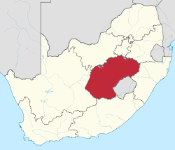
Free State ( Sesotho : Foreistata , Afrikaans : Vrystaat , English: Free State ) is a South African province in the middle of the republic. It is divided into four districts with 18 parishes and one metropolitan parish .
Forerunners are the Boer Republic of Orange Free State , founded in 1854 , which was independent until the end of the Second Boer War in 1902 and was united with the rest of the country to form the South African Union in 1910 . The Orange Free State (Oranje-Vrystaat) kept its name, but was now a province whose name was eventually changed by the Constitution of the Republic of South Africa Amendment Act No. 20 of 1995 was shortened to Free State from July 1995 .
geography
Free State is located in the central lowlands of South Africa and is characterized by agriculture. Over 30,000 farms produce more than 70% of South African agricultural products. Some of the richest gold and diamond mines in the world are also located in the Free State.
The Free State borders Lesotho in the southeast .
Districts with the parishes
The territorial structure of the Province of Free State consists of four district municipalities with 18 local municipalities and one metropolitan municipality .
| District / Metropolitan Municipality | Local parishes | |
|---|---|---|
| 1. | Fezile Dabi | Mafube , Metsimaholo , Moqhaka and Ngwathe |
| 2. | Lejweleputswa | Masilonyana , Matjhabeng , Nala , Tokologo and Tswelopele |
| 3. | Thabo Mofutsanyana | Dihlabeng , Maluti-a-Phofung , Mantsopa , Nketoana , Phumelela and Setsoto |
| 4th | Xhariep | Kopanong , Letsemeng and Mohokare |
| 5. | Mangaung Metropolitan Municipality | Metropolitan municipality |
Cities
The largest cities in the province are the capital Bloemfontein , Welkom , Botshabelo , Kroonstad , Virginia and Kutlwanong (near Welkom).
Parks and nature reserves
- Caledon Nature Reserve
- Erfenis Dam Nature Reserve
- Gariep Dam Nature Reserve
- Golden Gate Highlands National Park
- Kalkfontein Nature Reserve
- Koppies Dam Nature Reserve
- Seekoeivlei Nature Reserve
- Tussen-die-Riviere Nature Reserve
- Tweefontein Nature Reserve
- Willem Pretorius Game Reserve
Population and languages
According to the results of the 2001 census, 88% of the population were black, 8.8% were whites, 3.1% were colored ( Afrikaans : Kleurlinge , literally “colored”) and 0.1% were Indians and Asians. The low proportion of Asians is due to the fact that Asians were refused entry to the Free State during apartheid .
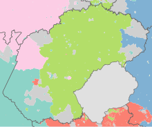
Sesotho stated 64.4% of the population as their mother tongue, Afrikaans 11.9%, IsiXhosa 9.1%, Setswana 6.8%, IsiZulu 5.1%, English 1.4%, IsiNdebele 0.4%.
| year | population |
|---|---|
| 1996 (census) | 2,633,504 |
| 2001 (census) | 2,706,775 |
| 2011 (census) | 2,745,590 |
| 2018 (estimate) | 2,954,300 |
history
Orange Free State
After the Cape Colony under British had come reign, who feared Buren to their cultural identity and tried in the Great Trek to colonize located further inland areas, including the area between the Orange and Vaal . The Afrikaans, as the Boers called themselves, founded several independent Boer republics inland . One of them was the Oranje Free State ( Oranje Vrystaat ).
This area was annexed by Great Britain in 1848 and called Orange River Sovereignty , but was able to achieve independence in 1854 under the name Oranje-Free State ( Dutch "Oranje-Vrijstaat", Afrikaans "Oranje-Vrystaat"). From the beginning the republic was under pressure from both Great Britain and the neighboring Basotho , with which it came to several wars under their ruler Moshoeshoe I. (see History of Lesotho ).
After the Second Boer War , the Orange Free State was finally annexed by the British in 1902 and a province ("Orange Free State") of the South African Union in 1910 . However, the name, territory and capital remained unchanged. In the 1960s, as a measure of the then South African apartheid policy, tribal areas of the black population were separated from the provincial territory. The homeland QwaQwa around Phuthaditjhaba and part of the homeland Bophuthatswana around Thaba Nchu were created . In 1994 these areas were reintegrated into the province.
In 1995 the province name was shortened to Free State .
List of Prime Ministers
- Mosiuoa Lekota ( ANC , May 11, 1994 to December 18, 1996)
- Ivy Matsepe-Casaburri (ANC, December 18, 1996 to June 15, 1999)
- Winkie Direko (ANC, June 15, 1999 to April 26, 2004)
- Frances Beatrice Marshoff (ANC, April 26, 2004 to 2009)
- Ace Magashule (ANC, May 6, 2009 to March 27, 2018)
- Sisi Ntombela (ANC, since March 27, 2018)
politics
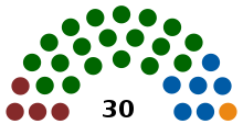
In the 2019 elections to the Provincial Legislature , the ANC remained the strongest party in the province of Free State despite losses. The mandates are distributed as follows.
| Political party | Seats | +/- |
|---|---|---|
| African National Congress (ANC) | 19th | −3 |
| Democratic Alliance (DA) | 6th | +1 |
| Economic Freedom Fighters (EFF) | 4th | +2 |
| Vryheidsfront Plus (VF +) | 1 | ± 0 |
| total | 30th |
Web links
- The Provincial Administration website (English)
- Parliament's website (English)
- Tourism Website of the province (English)
Individual evidence
- ↑ Statistics South Africa : Census 2011, Census in brief . online at www.statssa.gov.za (English, PDF file; 2.8 MB), PDF document p. 23, doc. p. 18.
- ^ SAIRR : South Africa Survey 1995/96 . Johannesburg 1996, p. 432
- ↑ Republic of South Africa: No. 20 of 1995: Constitution of the Republic of South Africa Amendment Act, 1995 at www.justice.gov.za (PDF), In: Government Gazette , 1995-07-03, Vol. 361, No. 16522, pp. 5
- ↑ 2001 census (result as pdf; 624 kB) ( Memento of May 18, 2012 in the Internet Archive ), p. 12.
- ↑ 2001 census (result as pdf; 624 kB) ( Memento from May 18, 2012 in the Internet Archive ), p. 16.
- ↑ South Africa: Provinces and Major Settlements - Population Statistics, Maps, Charts, Weather, and Web Information. Retrieved January 7, 2019 .
- ↑ Eyewitness News: Sisi Ntombela named FS Premier-Elect & Refilwe Mtsweni MP Premier-Elect . on ewn.co.za (English)


