
Limpopo (Province)
| Limpopo | ||
|---|---|---|
  |
||
| Symbols | ||
|
||
| Basic data | ||
| Country | South Africa | |
| Capital | Polokwane | |
| surface | 125,754 km² | |
| Residents | 5,404,868 (2011) | |
| density | 43 inhabitants per km² | |
| ISO 3166-2 | ZA-LP | |
| Website | www.limpopo.gov.za (English) | |
| politics | ||
| prime minister | Chupu Stanley Mathabatha | |
| Political party | ANC | |

Coordinates: 23 ° 54 ' S , 29 ° 22' E
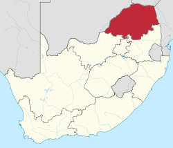
Limpopo is a South African province in the north of the republic. Around 5.4 million people live in an area of 125,754 km². The capital is Polokwane .
Until 1994 it was the northern part of the former Transvaal Province . The province was named after the Limpopo River in 2002 , while most of the cities on its territory were renamed. For a short time since 1994 it was called the Province of Northern Transvaal and thereafter, by the amending law Constitution of the Republic of South Africa Amendment Act No. 20 of 1995 from July 1995 initially Northern Province .
Limpopo borders Botswana to the northwest , Zimbabwe to the north and Mozambique to the east ; which also defines a section of the South African state border . The northern part of the Kruger National Park is in Limpopo Province.
history
In 2013, Stan Mathabatha replaced his predecessor Cassel Mathale (both ANC) as Prime Minister.
Districts with the parishes
The province is divided into five district and 22 local parishes :
.svg)
| District | Local parishes | |
|---|---|---|
| 1. | Capricorn | Blouberg , Lepelle-Nkumpi , Molemole and Polokwane |
| 2. | Mopani | Ba-Phalaborwa , Maruleng , Greater Giyani , Greater Letaba, and Greater Tzaneen |
| 3. | Sekhukhune | Elias Motsoaledi , Ephraim Mogale , Fetakgomo / Greater Tubatse and Makhuduthamaga |
| 4th | Vhembe | Collins Chabane , Makhado , Musina and Thulamela |
| 5. | Waterberg | Bela-Bela , Lephalale , Modimolle-Mookgophong , Mogalakwena and Thabazimbi |
Cities
- Bela-Bela (Warmbath)
- Louis Trichardt
- Lephalals (Ellisras)
- Modimolle (Nylstroom)
- Mokopane (Potgietersrus)
- Musina (Messina)
- Phalaborwa
- Polokwane (Pietersburg)
- Thabazimbi
- Thohoyandou
- Tzaneen
Population and languages

According to the results of the 2011 census, 96.7% of the population belonged to the black population, 2.6% to the whites, 0.3% to the coloreds and 0.3% to the Indians and Asians.
North Sotho gave 52.9% of the population as their mother tongue, Xitsonga 24%, Tshivenda 16.7%, Afrikaans 2.3%.
Population development
The following overview shows the population by area since the 1996 census.
| year | population |
|---|---|
| 1996 ( census ) | 4,576,566 |
| 2001 (census) | 4,995,462 |
| 2011 (census) | 5,404,868 |
| 2018 (estimate) | 5,797,300 |
politics

In the 2019 elections to the Provincial Legislature , the ANC remained the strongest party in Limpopo. The mandates are distributed as follows.
| Political party | Seats | +/- |
|---|---|---|
| African National Congress (ANC) | 38 | -1 |
| Economic Freedom Fighters (EFF) | 7th | +1 |
| Democratic Alliance (DA) | 3 | ± 0 |
| Vryheidsfront Plus (VF +) | 1 | +1 |
| total | 49 |
economy
The economic structure of Limpopo Province is mainly based on two sectors, agriculture and mining. Tourism is one of the most important areas of investment.
The deposits of mineral raw materials in Limpopo are diverse. The platinum group metals and diamonds are the most valuable sectors . Other mining products are chromium , nickel , cobalt , vanadium , tin , uranium , phosphates , copper and limestone . Antimony , gold , scheelite , magnetite , vermiculite , emerald , fluorite , mica , corundum , feldspar and rock salt as well as various types of natural stone are also extracted here in smaller quantities .
The mining of diamonds has gained importance for the north of the province since the end of the 20th century. The Venetia Mine near Musina is now the largest active diamond mining site in South Africa. After diamond grades were discovered in natural gravel deposits not far from Limpopo in 1903, interest in further explorations grew only slowly. In 1969 De Beers began concrete investigations into alluvial deposits at Musina. Later, in 1980, the primary deposits were discovered, whose kimberlite rock in the form of several chimneys and two dykes are the source for the diamonds from the sediment deposits discovered in 1903. The mining development for an initially underground and later open pit mine began in 1990. The mining activities began in 1993. Since 2004 the mine has been operating as the De Beers Consolidated Mines , the BEE sector in the De Beers Group. Another diamond mine near Venetia was opened in 2013 and is expected to provide around 4,000 jobs.
The distinctive profile of the agricultural economy with its around 170 large farms is characterized by the rich fruit and vegetable production. 75% of the country's mango fruit , 65% papayas , 36% of tea, 25% citrus , bananas and lychee , 60% of avocados and two thirds of its tomatoes are grown and harvested here. The annual amount of potatoes produced here is 285,000 tons. Other agricultural products include coffee , nuts, guava , sisal agave , sunflower , corn , wheat , timber , cotton and tobacco . There are also livestock farms in the province.
traffic
The high-performance traffic connections in Limpopo form trunk roads in north-south direction as well as a railway line coming from Zimbabwe and leading in the direction of Pretoria and rail and road connections from the region around Phalaborwa ( Phalaborwa Spatial Development Initiative ) in the direction of Komatipoort / Maputo ( Maputo Development Corridor ) . The export of export goods via the port of Maputo is very important for the local economy.
The area of the province crosses the national road N1 (with international border crossing to Zimbabwe in Beit Bridge ) and the national road N11 (with international border crossing to Botswana in Grobler's Bridge ). There are several small border posts on the border with Botswana. There are two crossings on the border with Mozambique that are only permitted for regional traffic.
There are several small airports and the Polokwane International Airport available for air traffic .
Must do in Limpopo (selection)
- Tzaneen Museum in Tzaneen
- This museum, founded in 1995, provides information about the history and culture of Limpopo. A significant part of the fund comes from the donation from Jürgen Witt, an immigrant who grew up in Berlin and who worked as the museum's curator for many years.
- Arend Dieperink Museum in Mokopane
- The region and its long history of settlement is the theme of this museum. It is located in a garden landscape in the city of Mokopane. In addition, organized explorations into the area are offered from here, where evidence of European settlement can be found. The namesake was a collector of indigenous artifacts that come from the cultures of the San and the Sotho and represent the society of the Voortrekker .
- Hugh Exton Photographic Museum in Polokwane
- The life's work of a former photographer, Hugh Exton, with a collection of 23,000 negatives is stored and exhibited in a former church building from 1890.
- Thulamela ruins in Kruger National Park
- The ruins of Thulamela are in the Pafuri area, a northern part of the Kruger National Park. It is an ancient settlement where ancestors of the San lived 100,000 years ago. Later, about 2000 years ago, Nguni immigrated here from the north and displaced the San population. The stone ruins that have been preserved date from the 13th century, the inhabitants of which extracted and processed iron ore.
- Polokwane Museum in Polokwane
- The museum was housed in an old Victorian-style commercial building from 1906. It is classified as a national monument. It shows evidence of the prehistoric development in the region up to the town history of Polokwane (Pietersburg).
- Masorini Village Museum, a museum village
- In the museum village there are testimonies of the living and living habits of a Stone Age society of hunters and collectors as well as their prehistoric metalworking. The open-air facility is connected to an archaeological excavation site.
- Foskor Mine Museum in Phalaborwa
- The museum mainly provides information about the mining of Phalaborwa and one of the world's largest opencast mines with a depth of 450 meters. There is also an exhibition section about the traditional culture of the region.
- 24 Degrees South in Hoedspruit
- 24 Degrees South is an exhibition of historic automobiles and motorcycles in a former silk spinner farm with commercial offers.
National parks and nature reserves
The province includes a cross-border park, five national and biosphere parks and 44 regional nature reserves.
Cross-border parks with neighboring countries
National parks and biosphere reserves
- Kruger National Park (also: Greater Limpopo Park)
- Mapungubwe National Park (formerly Limpopo / Shashe Transfrontier Conservation Area)
- Marakele National Park
- Waterberg Biosphere Reserve (2001)
- Vhembe Biosphere Reserve (2009)
Provincial parks and regional nature reserves
|
|
Web links
- Web presence of the provincial administration (English)
- Limpopo Tourism Agency (LTA): Website of the Limpopo Tourism Agency . on www.golimpopo.com (English)
Individual evidence
- ↑ Statistics South Africa : Census 2011, Census in brief . online at www.statssa.gov.za (English, PDF file; 2.8 MB), PDF document p. 23, doc. p. 18.
- ^ Local Government Handbook. South Africa: Limpopo Government . at www.municipalities.co.za (English).
- ^ SAIRR : South Africa Survey 1995/96 . Johannesburg 1996, p. 432
- ↑ Republic of South Africa: No. 20 of 1995: Constitution of the Republic of South Africa Amendment Act, 1995 . on www.justice.gov.za (PDF, English), In: Government Gazette , 1995-07-03, Vol. 361, No. 16522, p. 5.
- ^ Local Government Handbook. South Africa: Limpopo Municipalities . at www.municipalities.co.za (English).
- ^ Statistics South Africa : Limpopo . on www.statssa.gov.za (English), interactive map.
- ↑ a b 2011 census: Limpopo . accessed on July 15, 2020.
- ↑ South Africa: Provinces and Major Settlements - Population Statistics, Maps, Charts, Weather, and Web Information. Retrieved January 7, 2019 .
- ^ A b c Limpopo Provincial Government: About Limpopo - Provincial Economy and Investment . at www.limpopo.gov.za (English).
- ↑ mining-technology.com: Venetia Diamond Mine, South Africa . at www.mining-technology.com (English).
- ^ SABC: New De Beers mine to create thousands of jobs . SABC announcement of October 22, 2013 on www.sabc.co.za ( Memento of April 11, 2015 in the Internet Archive ) (English)
- ^ Maputo Corridor Logistics Initiative: Spatial Development Initiative . on www.mcli.co.za ( Memento from March 4, 2016 in the Internet Archive ) (English)
- ↑ iINFO: Tzaneen Museum . on www.iinfo.co.za (English)
- ↑ Matthys Strydom: Jurgen Witt, Museum Man of Tzaneen . on www.showme.co.za (English)
- ↑ SouthAfrica.com Services: Arend Dieperink Museum in Mokopane . on www.southafrica.com (English)
- ^ SA-Venues: About Hugh Exton Photographic Museum . at www.sa-venues.com (English).
- ^ South African History Online : Thulamela Archaeological Site . at www.sahistory.org.za (English).
- ^ South African History Online: Polokwane Museum . at www.sahistory.org.za (English).
- ^ SA-Venues: About Masorini Village Museum . at www.sa-venues.com (English).
- ^ SA-Venues: About Foskor Mine Museum . at www.sa-venues.com (English).
- ^ SA venues: About 24 Degrees South . at www.sa-venues.com (English).
- ^ Limpopo Tourism Agency: Our parks . at www.golimpopo.com (English).
- ↑ a b UNESCO : South Africa. Focal point for biosphere reserves . at www.unesco.org (English).