Thabazimbi
| Thabazimbi | ||
|---|---|---|
|
|
||
| Coordinates | 24 ° 35 ′ S , 27 ° 24 ′ E | |
| Basic data | ||
| Country | South Africa | |
| Limpopo | ||
| District | Waterberg | |
| ISO 3166-2 | ZA-LP | |
| local community | Thabazimbi | |
| height | 970 m | |
| Residents | 32,364 (2011) | |
| founding | 1919 | |
|
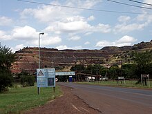
Center of Thabazimbi
|
||
Thabazimbi is a city in the Limpopo province of South Africa . It is the administrative seat of the Local Municipality Thabazimbi in the District of Waterberg .
geography
In 2011, Thabazimbi had 32,364 inhabitants (2011 census), who were divided between the main places Thabazimbi and Thabazimbi A.
The city lies at the foot of the over 1600 meter high Ysterberg; The Waterberg ridge extends east of the city . The Crocodile River , which flows into the Limpopo , flows just a little south .
history
In 1919, large iron ore deposits were discovered at today's location . The name comes partly from the Sepedi , partly from the isiZulu and means "Eisenberg". In the 1930s, a railway line from Rustenburg reached the place that was given city rights in 1953 . In 2003, a training camp for the rugby national team took place in the city, known nationwide as Kamp Staaldraat ( Afrikaans for "barbed wire camp"). The players were treated inhumane there. In 2015 it was announced that the mine would be closed due to a lack of profitability after a closure had been postponed several times.
Economy and Transport
The main source of income is iron ore mining by the Kumba Iron Ore company. Over two million tons of ore are extracted annually in the open pit . It is driven from Thabazimbi to the ArcelorMittal Iron and Steel Works . Thabazimbi is of touristic importance as a place to stay in the nearby Marakele National Park and other protected and hunting areas not far from the city.
The city is connected to the trunk road network via the R510 road, which connects Lephalale in the north with Rustenburg in the south, and the R511, which leads to Brits in the southeast. Thabazimbi is located on a railway line that leads from Brits to the Matimba power plant north of Thabazimbi and is operated in freight traffic.
Web links
- Thabazimbi at sa-venues.com (English)
Individual evidence
- ↑ 2011 census: Thabazimbi , 2011 census: Thabazimbi A , accessed on November 18, 2016
- ↑ Meaning of the community names ( Memento from August 29, 2019 in the Internet Archive ) (English)
- ↑ a b History of the city at infothabazimbi.co.za ( Memento from November 19, 2016 in the Internet Archive ) (English), accessed on November 19, 2016
- ↑ Press release by AngloAmerican Kumba of July 16, 2015 (English), accessed on November 18, 2016


