Waterberg (South Africa)
| Waterberg | ||
|---|---|---|
|
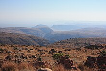
A gorge of the Lephalale at the height of the Lapalala Wilderness on the Waterberg |
||
| Highest peak | Kransberg ( 2100 m ) | |
| location | Limpopo Province , South Africa | |
|
|
||
| Coordinates | 24 ° 5 ′ S , 28 ° 9 ′ E | |
| rock | Bushveld complex , sandstone | |
| Age of the rock | Neo-Archean to around Paleoproterozoic | |
The Waterberg ( North Sotho : Thaba Meetse) is a mountain range in the north of the Limpopo province in South Africa . The massif extends over about 14,500 km², with an average height of 600 m. The highest peaks rise up to 1400 m above sea level. The steep walls, Härtlinge and Inselbergs visible today were created hundreds of millions of years ago by erosive forces. Modimolle is the largest city in the area. Furthermore, even Bela-Bela , Mookgophong , Vaalwater , Thabazimbi and Lephalale important.
The Waterberg is a biosphere reserve under the protection of UNESCO .
geology
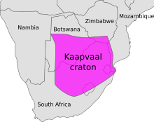
The Waterberg massif is based on the crustal block of the Kaapvaal craton , which formed around 2.7 billion years ago. Into this block encountered powerful intrusion minerals that the Bushveld complex formed. For example, elements of the vanadium and nickel groups were introduced into the rocks. The original extent of this upwelling extended over an area of over 250,000 km² and formed the geological unit of the so-called Waterberg Supergroup . Rivers such as the Lephalale shaped today's landscape through water erosion for hundreds of millions of years. This created the characteristic table and island mountains .
About 250 million years ago, the Kaapvaal craton collided with the supercontinent Gondwana , dividing itself into what is now South America , Africa (including the Arabian Peninsula ), Antarctica and Australia (including New Guinea ), and the Indian subcontinent .
Some rocky outcrops stand up to 550 meters above the surrounding plains and consist of sediments such as sandstone . The habitat is called dry forest or bushveld . The Waterberg massif is home to archaeological finds from the Stone Age and provides clues to human evolution .
history

The sandstone formations that were created were able to store sufficient groundwater to create a suitable environment for prehistoric humans. These early ancestors of anatomically modern humans ( Homo sapiens ) were protected by numerous mountain overhangs that were used as living centers and shelters. The ancestral line of humans goes back around three million years: around 40 km from Makapansgat ( Mokopane ) , fossils of Australopithecus africanus have been found. In 1961, fossil finds from Swartkrans , which had been known since 1949 and were initially called "Telanthropus capensis", were assigned to Homo erectus .
Stone tools have been found in the Waterberg Massif that prove settlement during the Stone Age . San first appeared in the Waterberg region around two thousand years ago. They left behind rock paintings , some of which are difficult to access, which can be explored on the rocks along the Lephalale . Popular motifs were rhinoceros and antelope .
Around 700 (for the first time) Bantu came to the area. Other sources point out that around 300 Bantu languages had already been established in the Transvaal and KwaZulu-Natal regions . They lived from the cultivation of millet and sorghum , which was guaranteed under conditions of irrigation, and from raising cattle. The resulting overgrazing led to the spread of tsetse flies , which, as carriers of African trypanosomiasis (sleeping sickness), caused enormous health problems in humans and were sometimes the cause of the depopulation of entire regions.
From 800 onwards, Nguni groups immigrated , which is indicated by relics of settlements and stables for cows. In the period that followed, they knew how to build dry stone walls and thus strengthened the existing forts from the Iron Age . Some of the walls still exist today.
The first white settlers came to Waterberg from 1808 and the first naturalists shortly before the middle of the 19th century. After initial feuds and struggles, the Boer settlers who had moved into the area entered into a peaceful coexistence with the local Bantu until around 1900, when the problems of overgrazing the grassy areas again arose.
ecology
The approximately 150 kilometers long mountain range of the Waterberg in the Limpopo province extends from Thabazimbi in the southwest to the Lephalale River in the northeast. The highest point is the 2100 m high Kransberg near Thabazimbi. He is the dominant figure in the Marakele National Park , which is named after him and is also called Kransberg National Park . There are a number of animal and nature reserves in this area . Sometimes there are camps and lodges in it. About 75 species of mammals, including the Big Five , as well as numerous species of birds live here. Wide savannahs with vegetation such as acacia , aloes , albizia and succulents are bordered by the rugged and steep mountain ranges. There are few paved roads.
Flora and fauna
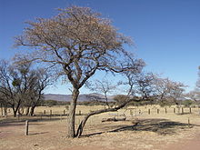
In addition to the type of savanna itself, the savannah consists essentially of grassland , fynbos and partly of deciduous forest . Rule of trees and tree-like mountain lilac , Myrobalan ( Combretum erythrophyllum and Terminalia sericea ) and lavender trees in front. In the dry winters they lose their leaves. The significant seed plants include several representatives of the species-rich Cape flora ; so fynbos, such as sour grass , cape reeds , myrtle-like , bug plants , silver tree and heather plants ( (Ericaceae) ) as well as milkweed plants , sweet grasses and rushes . These form the food base for impalas , kudus , cliff divers and wildebeest . Some pachypodia find habitats at the feet of the island mountains. The yellow acacia , which the San believed to allow communication with the ancestors, has a special meaning .
Native mammals are the giraffe , the black and white rhinoceros, as well as the warthog and porcupine . As predators, leopards , hyenas and lions are native. Top predators like the Nile crocodile and the hippopotamus live on the banks of the rivers . The biologist Eugène Marais devoted himself from 1905 to Waterberg intensively researching the behavior of baboons and termites . He was also interested in domestic snakes such as the black mamba and the spitting cobra . Some birds, such as the black-headed oriole and the white-backed vulture , also have their habitats in the Waterberg region .
Marakele National Park
The Marakele National Park is located in the middle of the Waterberg area north of Thabazimbi. The park is about 250 km from Johannesburg . It was founded in 1994, still under the name Kransberg National Park. You need a four-wheel drive vehicle in the park. Numerous large game species such as elephants, white and black rhinos, giraffes, buffalo, hippos, kudu, waterbuck and eland as well as big cats live here. The Cape Vultures , which are native to this area and circling high above the treetops, are of interest to bird lovers . The endangered bird is the largest breeding colony in South Africa.
The lush palm and tree ferns, as well as cedar species and yellow woods, create surprising contrasts to the mountains .
Lapalala Wilderness Area
The Lapalala Wilderness Area is a nature reserve. It is particularly known for the large number of termite mounds and the rare roan antelopes . The reserve was established in 1981 and is part of the Waterberg Biosphere Reserve . Over the years an environmental school has been established in the area, which enables young people in particular to develop an interest in the preservation of natural forms of life. Due to financial bottlenecks, the bush camps that had been set up were threatened with closure by 2001 . This was ultimately counteracted by reintroducing lions and elephants into the park.
climate
The average annual temperature is between 16 and 22 ° C. The average maximum temperature in January is 30 ° C, while the minimum monthly average temperature is 4 ° C in July. Precipitation increases from north to south. The climate at the Waterberg is subtropical . During the rainy season from November to March it is humid and hot. Many of the numerous rivers in Waterberg are flooded and roads can become impassable. Winters are dry and pleasantly warm. The entire region is free of malaria .
Web links
- Lapalala / Homepage (English)
Individual evidence
- ^ A b C. Michael Hogan, Mark L. Cooke and Helen Murray, The Waterberg Biosphere, Lumina Technologies , May 22, 2006
- ^ Waterberg Biosphere Reserve
- ↑ William Taylor, Gerald Hinde and David Holt-Biddle, The Waterberg, Struik Publishers, Cape Town, South Africa (2003)
- ↑ The Waterberg Massif, Limpopo Province, South Africa ( Memento April 29, 2012 on WebCite )
- ↑ Whether the continents Antarctica and Australia (Australo-Antarctica) were formed by the collision is controversial
- ↑ John JW Rogers, M. Santosh: Continents and Supercontinents , 2004, 289 pages.
- ^ Australopithecus africanus
- ↑ Andy IR Herries, Kaye E. Reed, Kevin L. Kuykendall, Alf G. Latham, Speleology and magnetobiostratigraphic chronology of the Buffalo Cave fossil site, Makapansgat, South Africa , Received September 30, 2004
- ↑ Winfried Henke , Hartmut Rothe : Stammesgeschichte des Menschen . Springer Verlag, 1999, p. 199
- ↑ a b c d Expertise on platinum mining in the Waterberg area (English, PDF), accessed on February 1, 2014
- ^ A b Language and Social History: Studies in South African Sociolinguistics , edited by Rajend Mesthrie, p. 39 ff.
- ↑ Claude Fuller: Tsetse in the Transvaal and Surrounding Territories (An Historical Review) , Pretoria 1923. ( Memento of February 27, 2012 in the Internet Archive ) (English, PDF)
- ^ Praagh / Lloyd, The Encyclopedic History of the Transvaal, Johannesberg (1906)
- ↑ The Waterberg Region in Limpopo Province South Africa.net , accessed January 30, 2014
- ↑ Vegetation of southern Africa: Savanna Biome ( Memento from April 17, 2014 in the Internet Archive )
- ↑ Vegetation of southern Africa: Grassland Biome ( Memento from October 18, 2014 in the Internet Archive )
- ^ Vegetation of southern Africa: Fynbos Biome
- ↑ Vegetation of southern Africa: Forest Biome ( Memento from July 25, 2013 in the Internet Archive )
- ^ Eugene Marais, Soul of the Ape , Human and Rousseau (1937)
- ^ Tracey Hawthorne, Common Birds of South Africa , Struik Publishing, South Africa (1998)
- ^ The Lapalala Wilderness Story
- ^ Department of Water Affairs and Forestry, South Africa. 2004. Internal Strategic Perspective: Limpopo Water Management Area: Prepared by Goba Moahloli Keeve Steyn (Pty) Ltd, in association with Tlou & Matji (Pty) Ltd and Golder Associates (Pty) Ltd. on behalf of the Directorate: National Water Resource Planning. Report No. P WMA 01/000/00/0304


