National Route 1
| National Route N1 in South Africa | |||||||||||||||||||||||||||||||||||||||||||||||||||||||||||||||||||||||||||||||||||||||||||||||||||||||||||||||||||||||||

|
|||||||||||||||||||||||||||||||||||||||||||||||||||||||||||||||||||||||||||||||||||||||||||||||||||||||||||||||||||||||||
| |
|||||||||||||||||||||||||||||||||||||||||||||||||||||||||||||||||||||||||||||||||||||||||||||||||||||||||||||||||||||||||
| map | |||||||||||||||||||||||||||||||||||||||||||||||||||||||||||||||||||||||||||||||||||||||||||||||||||||||||||||||||||||||||
| Basic data | |||||||||||||||||||||||||||||||||||||||||||||||||||||||||||||||||||||||||||||||||||||||||||||||||||||||||||||||||||||||||
| Operator: | South African National Roads Agency | ||||||||||||||||||||||||||||||||||||||||||||||||||||||||||||||||||||||||||||||||||||||||||||||||||||||||||||||||||||||||
| Start of the street: |
Cape Town ( 33 ° 55 ′ S , 18 ° 25 ′ E ) |
||||||||||||||||||||||||||||||||||||||||||||||||||||||||||||||||||||||||||||||||||||||||||||||||||||||||||||||||||||||||
| End of street: |
Musina ( 22 ° 13 ′ S , 29 ° 59 ′ E ) |
||||||||||||||||||||||||||||||||||||||||||||||||||||||||||||||||||||||||||||||||||||||||||||||||||||||||||||||||||||||||
| Overall length: | 1940 km | ||||||||||||||||||||||||||||||||||||||||||||||||||||||||||||||||||||||||||||||||||||||||||||||||||||||||||||||||||||||||
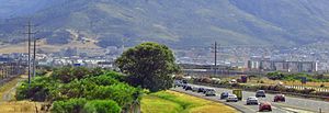
| The N1 near Century City, a suburb of Cape Town | |||||||||||||||||||||||||||||||||||||||||||||||||||||||||||||||||||||||||||||||||||||||||||||||||||||||||||||||||||||||||
|
Course of the road
|
|||||||||||||||||||||||||||||||||||||||||||||||||||||||||||||||||||||||||||||||||||||||||||||||||||||||||||||||||||||||||
The National Route 1 (short N1 ) is a South African national road that from Cape Town to the border with Zimbabwe north of the small town of Musina leads. It is also the main link between Johannesburg and Cape Town. Its southwestern section to the N12 is also a stretch of the Trans-African Highway Cairo-Gaborone-Cape Town .
Route

The N1 begins in the Central Business District of Cape Town as a motorway , runs in a north-easterly direction through the metropolitan area of the city (with six to eight lanes) out of the city to Paarl and then leads through the Hugenot Tunnel . Driving on the section through the tunnel is chargeable. The entire section to Paarl is developed as a motorway. There are plans for a bypass around Worcester . Some larger towns along the N1 between Worcester and Bloemfontein are Touwsrivier , Beaufort West and Colesberg . The N1 is well developed around Bloemfontein.
Winburg and Kroonstad are along the road to Johannesburg . A short stretch of the road around Kroonstadt is the Autobahn. South of the Vaal , the N1 is also multi-lane again. It leads past Vanderbijlpark into the Vaal Triangle . On this route south of Johannesburg, tolls are again levied. The N1 forms part of the Johannesburg ring road with the western bypass and then continues to Pretoria . There it becomes the Ben Schoeman Highway , which has a daily frequency of approximately 300,000 vehicles.
In Pretoria, where the N1 becomes the Pretoria bypass , it crosses with the R21 and the N4 and then continues to Polokwane (formerly Pietersburg). The multi-lane expansion ends at the Modimolle exit (Nylstroom). The section of the N1 motorway from Vanderbijlpark to Modimolle is the longest in South Africa at around 265 kilometers.
The N1 runs behind Polokwane as a four-lane expressway. From Pretoria to Polokwane, use is again subject to a charge. Although an unofficial heavy vehicle bypass already exists, there are plans for another around Polokwane. The road then leads through Louis Trichardt and Musina and ends at the state border with Zimbabwe in the area of the South African border checkpoint at Beit Bridge Border Post . The road then continues in Zimbabwe as the A6 national road, where it branches off shortly after the border town of Beitbridge to provide transport connections to Bulawayo or Harare .
The N1 enables good and fast transport connections between the north and the south of South Africa, especially the routes between Johannesburg and Pretoria (60 kilometers) and Johannesburg and Cape Town (1,400 kilometers).
The old street
The old route of the N1 was relocated in many places in South Africa - especially near large cities - in order to meet the standards of new highways. The old routes usually have the designation R101 and can often be used as alternative roads to the new, toll road sections. One example is the R101 over the Du Toitskloof Pass. The new N1 bypasses the pass almost completely and leads through the Hugenot Tunnel . However, the alternative road between Kroonstad and Parys is called R721 (and then R59 to the transition to the N1). There are several ways to bypass the N1 between Johannesburg and Parys. The official road for this is via the Golden Highway ( R553 ), although the old N1 follows the R42 to Vereeniging .
Web links
- South African National Roads Agency Ltd. (SANRAL) . on www.nra.co.za (English)
- SANRAL: N1-N27 Polokwane Eastern Ring Road . on www.nra.co.za (English)
Individual evidence
- ^ National Department of Transport, John Falkner et al .: RDDA South African Numbered Route Description and Destination Analysis . May 2012, PDF document p. 19. on www.transport.gov.za ( Memento of the original from February 1, 2014 in the Internet Archive ) Info: The archive link was inserted automatically and has not yet been checked. Please check the original and archive link according to the instructions and then remove this notice. (English)


