Colesberg
| Colesberg | ||
|---|---|---|
|
|
||
| Coordinates | 30 ° 43 ′ S , 25 ° 6 ′ E | |
| Basic data | ||
| Country | South Africa | |
| North Cape | ||
| District | Pixley Ka Seme | |
| ISO 3166-2 | ZA-NC | |
| local community | Umsobomvu | |
| height | 1374 m | |
| Residents | 16,869 (2011) | |
| founding | 1830 | |
| Website | colesberginfo.co.za (English) | |
|
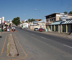
Main street in Colesberg
|
||
Colesberg (formerly Towerberg ) is a place in the South African province of Northern Cape . It is the administrative center of the municipality umsobomvu local municipality in the district of Pixley Ka Seme .
geography
Colesberg is a rural town in the Eastern Karoo . It is located on the national roads N1 and N9 . In 2011 it had 16,869 inhabitants. The former township of Kuyasa, east of the center, belongs to the place . To the west lies the frustoconical Coles Kop , which was also called Towerberg .
history
The place was founded in 1830 instead of a mission station of the London Missionary Society that was established in 1814, making it one of the oldest European settlements in the region. Initially the place was called Towerberg after the nearby mountain, later it was named after the then governor of the Cape Colony , Sir Galbraith Lowry Cole. Its earliest residents included some of the British settlers from 1820 . For many hunters and adventurers, Colesberg was the last Cape Colony outpost on their way to the interior of the continent. In 1840 Colesberg received parish status. An Anglican Church was built in 1854 and a Dutch Reformed Church nine years later . During the Second Boer War , the city fell to the British in 1900 after they had shot at Colesburg from the Coles Kop .
Economy and Transport
The main source of income is sheep breeding, especially merino sheep , and horse breeding. There is also tourism. Colesberg is important as a stopover for travelers.
Colesberg is a transport hub. The city is on the N1, which connects Johannesburg and Cape Town , among others . The N9 leads south to Middelburg and on to George . The R58 connects Colesberg east with Aliwal North and Elliot . The R717 leads north to Philippolis , the R369 north-west to Petrusville . Colesberg station is located east of Kuyana on the Bloemfontein - Beaufort West railway line , which runs almost parallel to the N1, and is used for freight traffic. Passenger trains from Johannesburg to Port Elizabeth pass there.
Attractions
Colesberg has numerous listed buildings from the 19th century in the center, the architecture of which is partly Cape Dutch and partly Georgian inspired. The Colesberg-Kemper Museum shows, among other things, a collection from 1880. Nearby is the Doornkloof Nature Reserve.
Personalities
The future President of the South African Republic, Paul Kruger (1825–1904), was born near Colesberg .
Web links
- Official website (English)
- History Cole Mountain (English)
- Colesberg at places.co.za (English)
Individual evidence
- ↑ 2011 census , accessed November 18, 2013
- ↑ a b c d history of Colesberg (English), accessed on August 19, 2013
- ↑ a b c Colesberg at places.co.za (English), accessed on August 18, 2013

