National Route 4
| National Route N4 in South Africa | ||||||||||||||||||||||||||||||||||||||||||||||||||||||||||||||||

|
||||||||||||||||||||||||||||||||||||||||||||||||||||||||||||||||
| map | ||||||||||||||||||||||||||||||||||||||||||||||||||||||||||||||||
| Basic data | ||||||||||||||||||||||||||||||||||||||||||||||||||||||||||||||||
| Operator: | South African National Roads Agency | |||||||||||||||||||||||||||||||||||||||||||||||||||||||||||||||
| Start of the street: |
Lobatse ( 25 ° 17 ′ S , 25 ° 43 ′ E ) |
|||||||||||||||||||||||||||||||||||||||||||||||||||||||||||||||
| End of street: |
Komatipoort ( 25 ° 27 ′ S , 31 ° 59 ′ E ) |
|||||||||||||||||||||||||||||||||||||||||||||||||||||||||||||||
| Overall length: | 718 km | |||||||||||||||||||||||||||||||||||||||||||||||||||||||||||||||
|
Course of the road
|
||||||||||||||||||||||||||||||||||||||||||||||||||||||||||||||||
The National Route 4 (short- N4 ) is a national road in South Africa . It is part of the Trans-Kalahari Highway from Walvis Bay ( Namibia ) to Maputo ( Mozambique ), which connects the coasts of the Atlantic and Indian Oceans across southern Africa . Since the completion of the central section in Botswana , the standard of the entire route is considered to be very high.
Route
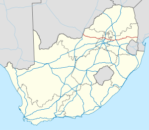
The national road enables traffic to flow from the Botswana border west of the city of Lobatse through the metropolitan area of the metropolitan municipality of Tshwane to the Lebombo border post on the border with Mozambique .
In the west, the national road begins at the Pioneer Gate / Skilpadshek border crossing . It takes on the traffic of the A2 trunk road and heads south-west to Zeerust , where there are branches of the regional roads R49 in the direction of Gaborone and R27 to Mafikeng . From Zeerust, the N4 stretches along with a railway line through a sparsely populated region that benefits from a few mining operations. In the village of Groot Marico it crosses the Groot Marico River . In Swartruggens the regional roads R53 and R509 branch off to the south and south-east. This is where the previously accompanying railway line turns to the southeast in the direction of Krugersdorp .
Further to the east, it passes through sparsely populated terrain. Shortly before Rustenburg , the R565 branches off into the Pilanesberg region. Rustenburg is an important center of South African platinum mining . This is where the R510 , which runs north towards Lephalale, and the R30, which leads to Klerksdorp on the N12 , begin. Now the N4 turns southeast towards the Magaliesberg and runs in a platinum mining region south of Marikana to the industrial region west of Pretoria.
The N4 branches off southwest of Brits . The old southern branch touches Hartbeespoort , not far from it the Hartbeespoort reservoir , and enables a connection to Johannesburg with the branching off regional roads R511 and R512 . This multi-lane route now leads to the center of Pretoria, where there is a junction with the national road N1 . The northern and new branch of the N4 runs towards the north of Pretoria, where it joins the N1. This saves around 30 minutes of travel time in cross-regional through traffic.
From Pretoria, the N4 continues in an easterly direction, past the smaller towns of Bronkhorstspruit , Balmoral and leaving the province of Gauteng to eMalahleni (Witbank). The N12, which leads to Johannesburg, branches off here. The eastward traffic volume will now be included in a multi-lane expansion. This expansion stage ends at the intersection with the N11 . Many of the country's coal-fired power plants are located along the highway in Mpumalanga Province.
The N4 now runs through Mpumalanga and approaches the Pretoria – Maputo railway at Wonderfontein . In the further direction it enables connections to the cities of eMakhazeni (Belfast), Waterval-Boven and Mbombela (Nelspruit) on the route. To the west of Waterval-Boven, the trunk road branches into a northern and southern route, which merge again at the Montrose Pass before Mbombela. In this city, the R40 from the north branches off to the south, which enables traffic connections to Barberton and neighboring Swaziland .
From Nelspruit, the trunk road continues in the Umgwenya valley to Kaapmuiden and from here only smaller towns are tangent to Komatipoort . Nearby is the Komatipoort / Ressano Garcia border crossing on the border between South Africa and Mozambique . Traffic in Mozambique continues on the EN4 and can reach Maputo on this trunk road.
Route expansion
The section of road from Pretoria to near Middelburg , the N4 Platinum Highway , bypasses the capital and consists of structurally separate carriageways. The other parts of the route only consist of a single wide carriageway. The bypass around Rustenburg was built in 2009. Some sections are subject to tolls, for example the part of the Maputo Corridor Toll Route .
Over the decades, South Africa has gradually invested in the expansion of the national road in order to make freight transport from the provinces of Gauteng , Limpopo and Mpumalanga to the Port of Maputo more efficient.
Web links
- South African National Roads Agency Ltd. (SANRAL) . on www.nra.co.za (English)
- SANRAL: Road Conditions N4 . on www.nra.co.za (English)
Individual evidence
- ↑ The N4 Route. on www.bakwena.co.za (English)
