
Magaliesberg
| Magaliesberg | ||
|---|---|---|
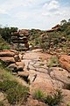
 Hamerkop Kloof in the Magalies Mountains |
||
| Highest peak | Nooitgedacht ( 1853 m ) | |
| location | Provinces North West and Gauteng ( South Africa ) | |
|
||
| Coordinates | 25 ° 45 ′ S , 27 ° 52 ′ E | |

The Magaliesberge are a mountain range in South Africa in the provinces of Northwest and Gauteng . It extends in an east-west direction from Pretoria to Rustenburg and from there with a northern branch to south of the Pilanesberg .
The Magaliesberg are among the oldest mountains on earth. They were formed around two billion years ago when the earth's crust was broken up and lifted by rising magma . Due to its old age, the mountains are badly eroded. The highest point, roughly in the middle of the mountain range, reaches 1,853 meters above sea level. The surrounding highveld is around 1,500 meters high.
The Voortrekker defeated the Zulu leader Mzilikazi in the Magalies Mountains . As a result, Boers settled here and achieved quite high yields on their fields. During the Second Boer War , several battles were fought in the Magalies Mountains. The Hartbeespoort reservoir , built in 1923, is located in the eastern part of the Magaliesberg Mountains.
There are several nature reserves within the Magaliesberg, including the Kgaswane Mountain Reserve near Rustenburg and the Mountain Sanctuary Park near Buffelspoort .
The Magaliesberg are named after the local chief Mogale, who ruled there around 1850.
photos

Ridge of the Magaliesberg at the Hartbeespoort reservoir

The mountain range of the Magaliesberg (and Pilanesberg - top left)

The Tonquani Gorge in the Magalies Mountains
Landscape in the Mountain Sanctuary Park
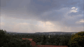
Time lapse video of rain showers over the Magalies Mountains
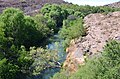
The Magaliesrivier south of the Mgaliesberg

The Magaliesberg


Individual evidence
- ^ Philips' College Atlas for Southern Africa . George Philip and Son limited, London 1976, ISBN 0-540-05320-1