
Mpumalanga
| Mpumalanga Eastern Transvaal (before 1995) |
|||
|---|---|---|---|
  |
|||
| Symbols | |||
|
|||
| Basic data | |||
| Country | South Africa | ||
| Capital | Mbombela | ||
| surface | 76,495 km² | ||
| Residents | 4,039,939 (2011) | ||
| density | 53 inhabitants per km² | ||
| ISO 3166-2 | ZA-MP | ||
| Website | www.mpumalanga.gov.za (English) | ||
| politics | |||
| prime minister | Refilwe Mtsweni | ||
| Political party | ANC | ||


Coordinates: 25 ° 28 ′ S , 30 ° 54 ′ E
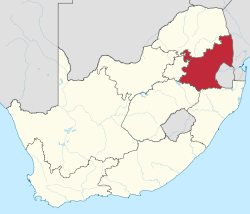
Mpumalanga (before 1995 Eastern Transvaal ) is a South African province in the northeast of the republic. Around 4.3 million people live in an area of 76,495 km² (as of 2016) (2011: 4.0 million). The capital is Mbombela .
In the north Mpumalanga borders on the Limpopo Province , in the east on the states of Swaziland and Mozambique ; to the south are the provinces of KwaZulu-Natal and Free State , to the west of which are Gauteng . Within the province lies the southern part of the Kruger National Park .
Surname
Mpumalanga is the Siswati name for the "place where the sun rises".
Districts with the parishes
.svg)
.svg)
The province is divided into three district and 17 local parishes .
| District | Local parishes | |
|---|---|---|
| 1. | Gert Sibande | Albert Luthuli , Dipaleseng , Govan Mbeki , Lekwa , Mkhondo , Msukaligwa and Pixley Ka Seme |
| 2. | Nkangala | Dr JS Moroka , Emalahleni , Emakhazeni , Steve Tshwete , Thembisile Hani and Victor Khanye |
| 3. | Ehlanzeni | Bushbuckridge , City of Mbombela , Nkomazi and Thaba Chweu |
Cities
- Mbombela (Nelspruit)
- Barberton
- Bethal
- Ermelo
- eMalahleni (Witbank)
- Hazyview
- Mashishing (Lydenburg)
- Middelburg
- Piet Retief
- Secunda
- Skukuza
- Standerton
- Volksrust
Population and languages

According to the results of the 2011 census, 90.7% of the population were black, 7.5% were whites, 0.9% were colored ( Afrikaans : Kleurlinge , literally “colored”) and 0.7% were Indians and Asians .
Siswati was the mother tongue of 27.7% of the population, isiZulu 24.1%, Xitsonga 10.4%, South Ndebele 10.1%, North Sotho 9.3%.
Population development
The following overview shows the population by area since the 1996 census.
| year | population |
|---|---|
| 1996 (census) | 3,123,869 |
| 2001 (census) | 3,365,554 |
| 2011 (census) | 4,039,939 |
| 2018 (estimate) | 4,523,900 |
politics

In the 2014 elections to the Provincial Legislature , the ANC remained the strongest party in Mpumalanga. The Economic Freedom Fighters took on the role of the official opposition for the first time. The mandates are distributed as follows.
| Political party | Seats | +/- |
|---|---|---|
| African National Congress (ANC) | 22nd | -2 |
| Economic Freedom Fighters (EFF) | 4th | +2 |
| Democratic Alliance (DA) | 3 | ± 0 |
| Vryheidsfront Plus (VF +) | 1 | +1 |
| total | 30th |
The prime minister until the end of February 2018 was David Mabuza , who had been appointed Vice President of South Africa. Refilwe Mtsweni took over the office on a provisional basis . She was sworn in as Prime Minister on March 20, 2018.
Partnerships
Mpumalanga has had a partnership with the city of Chongqing , People's Republic of China , since 2002 .
Mpumalanga has been a partner region of the state of North Rhine-Westphalia since 1995 .
economy
The province is one of the most important industrial regions in South Africa and is rich in mineral resources such as gold , platinum metals , chrome ores , iron ores , copper ores , coal and valuable rocks.
Due to the natural raw material situation in the province, companies for the production of chrome alloys and steel products dominate the heavy industry. Their locations are mainly in the north of the Highveld . In Middelburg there are other steelmakers and producers of vanadium products . The largest coal mines in Africa are located in the vicinity of the city of eMalahleni . Their coal is either used for domestic energy generation or transported as export goods mainly by rail on the Richards Bay Coal Line to the coal terminal in the port of Richards Bay .
The industry in the Lowveld region focuses on the processing of agricultural and forestry products . Because of the proximity to the port of Maputo , the industry has a high export share here. South Africa's largest paper manufacturer produces in Ngodwana.
In Secunda , Sasol operates one of the largest synthesis plants in the country for liquid fuels. The country's largest power plants , whose energy source is coal, work in Mpumalanga . The Kendal power plant is one of the individual locations with the highest power plant outputs .
The agricultural product range is extensive. Citrus fruits are grown in Mpumalanga , the center being the region around Mbombela. The agricultural sector also deals with the cultivation of other fruits, such as mangoes , avocados , lychee fruits , bananas , papayas , grenadilles and guavas . Around Groblersdal , which belonged to Mpumalanga until 2011 and is now in Limpopo, agricultural areas are intensively irrigated. In addition to the production of citrus fruits, tobacco, wheat, cotton and vegetables are grown here. In the south of the province, near Carolina , Bethal and Ermelo , potatoes, peanuts, corn and sunflowers are grown. Sheep breeding is also practiced here.
traffic
Efficiently developed traffic routes run through the province in a west-east direction. These are the Pretoria – Maputo railway line and the N4 and N17 national roads . The national road N11 runs from the north to the southern parts of the country to KwaZulu-Natal .
There are several smaller airports for air traffic. Kruger Mpumalanga International Airport, northeast of the provincial capital Mbombela, serves as an international and domestic airport .
National parks and nature reserves
.jpg)

- Andover Nature Reserve
- Barberton Nature Reserve
- Blyde River Canyon
- Crocodile Bridge Gate
- Gustav Klingbiel Nature Reserve
- Drakensberg
- Dullstroom Nature Reserve
- God's Window
- Kruger National Park
- Ligwalagwala Conservancy
- Loskop Dam Nature Reserve
- Mabusa Nature Reserve
- Marloth Park
- Mdala Nature Reserve
- Mjejane Game Reserve
- Mkhombo Nature Reserve
- Dawn Dam Nature Reserve
- Mount Sheba Nature Reserve
- Mthethomusha Game Reserve
- Nkomazi Game Reserve
- Nooitgedacht Dam Nature Reserve
- Lydenburg Nature Reserve
- Ohrigstad Nature Reserve
- Rocky Drift Nature Reserve
- Sabi Sands Game Reserve
- Songimvelo Game Reserve
- SS Skosana Nature Reserve
- Steenkampsberg Nature Reserve
- Sterkspruit Nature Reserve
- Lost Vallei Nature Reserve
Web links
- www.mpumalanga.gov.za (website of the provincial administration) (English)
- Description of the Transnet Freight Rail network in the province. on www.safiri.co.za (English)
Individual evidence
- ↑ Statistics South Africa : Census 2011, Census in brief . online at www.statssa.gov.za (English, PDF file; 2.8 MB), PDF document p. 23, doc. p. 18.
- ↑ Statistics website of the South African government from 2009 (English, PDF file; 4.1 MB), accessed on October 27, 2012
- ↑ Stats SA: Community Survey 2016 (accessed September 16, 2017)
- ^ A b Mpumalanga Provincial Government: About Mpumalanga Province . on www.mpumalanga.gov.za (English)
- ^ Local Government Handbook. South Africa: Mpumalanga Municipalities . at www.municipalities.co.za (English).
- ^ Statistics South Africa : Northern Cape . on www.statssa.gov.za (English), interactive map.
- ↑ Statistics South Africa (Ed.): Census 2011: Census in brief . Pretoria 2012, ISBN 978-0-621-41388-5 ( gov.za [PDF]).
- ↑ South Africa: Provinces and Major Settlements - Population Statistics, Maps, Charts, Weather, and Web Information. Retrieved January 7, 2019 .
- ↑ Report at ziwaphi.com from March 23, 2018 (English), accessed on April 7, 2018
- ^ Chongqing Municipal Government
- ^ State Chancellery of North Rhine-Westphalia: Mpumalanga / South Africa . on www.mbem.nrw.de (German)