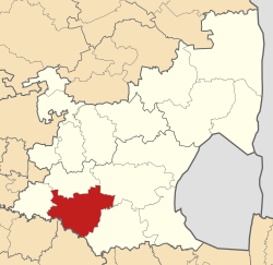
Lekwa
| Lekwa Local Municipality of Lekwa |
||
|---|---|---|
 |
||
| Symbols | ||
|
||
| Basic data | ||
| Country | South Africa | |
| province | Mpumalanga | |
| District | Gert Sibande | |
| Seat | Standerton | |
| surface | 4585 km² | |
| Residents | 115,662 (October 2011) | |
| density | 25 inhabitants per km² | |
| key | MP305 | |
| ISO 3166-2 | ZA-MP | |
| Website | www.lekwalm.gov.za (English) | |
| politics | ||
| mayor | Linda Dlamini | |
Coordinates: 26 ° 57 ′ S , 29 ° 15 ′ E
Lekwa is a municipality in the Gert Sibande district , Mpumalanga Province in South Africa with its seat in Standerton .
The municipality is named after the isiZulu word Ligwa for the river Vaal that flows through the municipality. It has an area of 4585 square kilometers.
Localities
- Bettiesdam
- Elmtree
- Holmdene
- Maizefield
- Meyerville
- Morning zone
- Flat edge
- Roberts drift
- Standerton
- Stanfield Hill.
population
The population increased in five years from 115,662 (2011 census) to 123,419 (2016).
Of the residents in 2011, 84.2% were black, 11.4% white, 2.9% colored and 1.2% Indian or Asian .
The first language was 65% isiZulu , 13% Afrikaans , 10.1% Sesotho , 3.5% English, 1.5% isiXhosa , 1.1% each isiNdebele and Siswati , 0.7% Setswana and at 0.6% Sepedi .
Web links
- Official website (English)
- Portrait at localgovernment.co.za (English)
Individual evidence
- ^ Community names of South Africa
- ↑ Demographic data from Lekwa (English), accessed on April 3, 2016
- ↑ www.localgovernment.co.za: Lekwa Local Municipality (MP305): Demographic
- ↑ Stats SA: Community Survey 2016 (accessed September 17, 2017)
- ↑ http://www.statssa.gov.za/?page_id=993&id=lekwa-municipality
