Mooi River
| Mooi River | ||
|---|---|---|
|
|
||
| Coordinates | 29 ° 12 ′ S , 30 ° 0 ′ E | |
| Basic data | ||
| Country | South Africa | |
| KwaZulu-Natal | ||
| District | umgungundlovu | |
| ISO 3166-2 | ZA-KZN | |
| local community | Mpofana | |
| height | 1371 m | |
| Residents | 2874 (2011) | |
| founding | 1884 | |
|
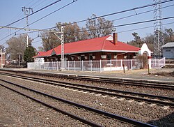
Mooi River station
|
||
Mooi River ( Afrikaans Mooirivier ) is a small town in the South African province of KwaZulu-Natal . It is located in the Mpofana parish in the uMgungundlovu district . Mooi is Afrikaans and stands for 'beautiful'. So the city is called 'Beautiful River'. In 2011, Mooi River had 2,874 residents.
The main economic pillar is agriculture, mainly cattle breeding and dairy farming. Racehorses are also bred. The stud farms located here are among the best in South Africa.
geography
Mooi River is in the northern Midlands, just off the N3 and the Johannesburg to Durban railway line . The city is approximately 160 kilometers from the east coast and is at an altitude of 1371 meters above sea level. The Drakensberg begin 30 kilometers to the west .
The average rainfall in Mooi River is 648 millimeters. Most of the precipitation falls in summer (November to March). The lowest amount of precipitation occurs in June with 2 millimeters. Most of the precipitation falls in January (113 millimeters). The average midday temperature in Mooi River varies from 16.3 ° C in June to 24.2 ° C in January. The coldest month is June. Here the average minimum nighttime temperatures are 0.6 ° C.
history
In 1852 the first European settlement was founded on the Mooi River . In 1866 it was officially named Weston in honor of the then governor of Natal , Martin West.
In 1879 the Irishman Alexander Lawrence bought the Grantleigh farm a little further upstream from Weston. When the Durban to Johannesburg railroad was built in 1884 , it passed through Lawrence's farm. He then established the Lawrenceville village on his farm.
There were some skirmishes here during the Second Boer War . A military hospital with 1500 beds was set up.
In 1921 the place received city rights and was renamed Mooi River.
Attractions
- The Mooi River Falls is an 80 meter high and 50 meter wide waterfall located near the city.
- Outside the city is the Craigieburn Reservoir. There are campsites here.
Personalities
- Candice Swanepoel (* 1988), model, born and raised in Mooi River
Web links
- Tourism Website of Mooi River (English)
Individual evidence
- ↑ a b Mooi River ( English ) Midlands Reservations . Archived from the original on March 27, 2012. Info: The archive link was inserted automatically and has not yet been checked. Please check the original and archive link according to the instructions and then remove this notice. Retrieved March 26, 2010.
- ↑ 2011 census , accessed November 17, 2013
- ↑ a b c d Mooi River - Natal Midlands ( English ) Country Roads . Retrieved March 26, 2010.
- ↑ a b c d e f Mooi River ( English ) SA Routes, Bookings and Info Systems . Archived from the original on August 30, 2009. Info: The archive link was automatically inserted and not yet checked. Please check the original and archive link according to the instructions and then remove this notice. Retrieved March 26, 2010.
- ↑ Mooirivier, South Africa Page ( English ) Falling Rain Genomics, Inc. . Retrieved March 26, 2010.
- ↑ Mooi River climate ( English ) SA Explorer . Retrieved March 26, 2010.


