Okiep
| Okiep | ||
|---|---|---|
|
|
||
| Coordinates | 29 ° 36 ′ S , 17 ° 54 ′ E | |
| Basic data | ||
| Country | South Africa | |
| North Cape | ||
| District | Namakwa | |
| ISO 3166-2 | ZA-NC | |
| local community | Nama Khoi | |
| height | 1159 m | |
| Residents | 6304 (2011) | |
Okiep is a town of around 6,304 inhabitants (2011 census) in the municipality of Nama Khoi , Namakwa District , Northern Cape Province in South Africa . It is located at an altitude of 1,159 meters on the N7 road , eight kilometers north of Springbok and 118 kilometers south of Vioolsdrift .
The city name in its original spelling O'okiep is derived from the Nama word U-gieb , which means "great brackish water source " or "place of great brackish water".
history
The city was the first mining town in South Africa and once the center of copper mining in South Africa. Here won indigenous miners copper long before the Dutch East India Company this deposit in 1685 at the instigation of as part of an expedition Simon van der Stel explored first. This expedition began on August 25th and was led by Friederich Mathias van Werlinckhof. In July 1761, under the leadership of Hendrik Hop, another expedition to the Namaqualand started , which expanded our previous knowledge of the extent of the copper ore deposit. The prospective area extends in the vicinity of the mining town on an area of about 3000 square kilometers.
At the end of the 19th century, copper mining was one of the most productive in southern Africa. The rich copper deposits were mined here from 1852 by European immigrants. Initially, the ore was transported from the mines to the port in Port Nolloth in ox carts so that it could be shipped there, from around 1865 on a narrow-gauge railway . Since there was a lack of water for the steam locomotives, the wagons were pulled by mules until 1890 . Okiep's copper mining was stopped for the first time around 1918, resumed after 1922 and operated until the end of the 1920s. The dismantling stopped between 1931 and 1937. In 1940 a US-Canadian company built some smelting plants. Copper mining in the Okiep area continued beyond 1961.
A 27-kilometer pipeline was built to supply the mining town with groundwater from the dry valley in the middle course of the Buffels River to its destination. However, the amount of water available in this way limited the annual yield of the extracted copper ore to a maximum of 1.8 million tons.
Attractions
- Spring blossom of the Namaqualand
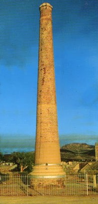
- Ventilation shaft
- a ventilation facility built in 1880 by the Cape Copper Company , now a national monument
- Cornish Pump House
- Still functional pump house for draining the mine from 1882.
Personalities
- Jeff Coetzee (born 1977), tennis player
literature
- RH Boer: Bibliography on the Geology of the Okiep Copper District, Namaqualand, South Africa, 1685-1990 . University of the Witwatersrand, Economic Geology Research Unit. Information Circular No. 241. Johannesburg 1991, online at www.wits.ac.za (English, PDF), ISBN 1-874856-48-6
Web links
- Tourist information about Okiep (English)
Individual evidence
- ↑ 2011 census: Okiep , accessed November 18, 2013.
- ^ Peter Edmund Raper : Dictionary of Southern African Place Names . Lowry Publishers, Johannesburg 1987 (2nd ed.), P. 250.
- ^ A b c René Arthur Pelletier: Mineral Resources of South-Central Africa . Oxford University Press , Cape Town / London / New York / Toronto 1964, p. 85.
- ↑ John M. Smalberger: Aspects of the History of Copper Mining in Namaqualand Cape Town, 1969, master work of the University of Cape Town (English, Link ).
- Jump up ↑ RH Boer: Bibliography on the Geology of the Okiep Copper District, Namaqualand, South Africa, 1685-1990 Johannesburg, 1991, University of Witwatersrand , Economic Geology Research Unit, Information Circular No. 241. ISBN 1-874856-48-6 ( link ).
- ↑ Traugott Molter: Water balance and irrigation agriculture in the Cape . Franz Steiner Verlag , Wiesbaden 1966, p. 34.
- ↑ a b Traugott Molter: water balance . 1966, pp. 34, 78

