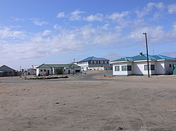
Port Nolloth
| Port Nolloth | ||
|---|---|---|
|
|
||
| Coordinates | 29 ° 14 ′ S , 16 ° 52 ′ E | |
| Basic data | ||
| Country | South Africa | |
| North Cape | ||
| District | Namakwa | |
| ISO 3166-2 | ZA-NC | |
| local community | Richtersveld | |
| Residents | 6092 (2011) | |
| founding | 1854 | |
Port Nolloth is a port city in the local municipality of Richtersveld , Namakwa District , Northern Cape Province in South Africa . In 2011 the place had 6,092 inhabitants with 1,831 households.
history
Port Nolloth's history began around 1854/55 when a commander Nolloth set up a transshipment port in this bay to transport the copper ore extracted from the hinterland near Springbok and Okiep . Initially, the ores, which had already been partially processed, were transported from the mines to the port by ox carts , and from 1876 onwards on a narrow-gauge railway line . This railway line was discontinued as unprofitable in 1928 and again in 1943. After the Second World War , the line was dismantled except for two sections. One runs 8 kilometers inland from the port in Port Nolloth to the 5-mile point where large water tanks have been set up. The other, 25-kilometer-long section of the route remained between the Okiep and Nababeep mining sites as an industrial railway.
geography
There are sandy stretches of coast to the north and south of the city. The Benguela Current, which comes from Antarctica , ensures that the water temperatures rarely exceed 16 ° C. As a result, there is hardly any evaporation. The city is located by the sea, but still in an arid area with only 45 mm of precipitation per year. The regular wafts of mist that pull in from the sea at night alone ensure regular moisture from February to July. The mouth of the Oranje and with it the border with Namibia lies around 80 kilometers to the north .
economy
Diamond search boats stationed in Port Nolloth are allowed - with a license from De Beers - to search the seabed for diamonds . Over millions of years, these were transported from the inland to the Atlantic by former rivers. The submarine layers of sediment from former rivers are sucked off with large suction hoses and transported to the boats by means of huge water pumps. There the conveyed masses are screened and pre-separated.
Since the port basin of Port Nolloth is very shallow, only ships with shallow drafts could dock here. Today small fishing boats - mainly lobsters are caught - and diamond search boats dominate the scene.
There is no bathing tourism in Port Nolloth because of the low water temperatures and the frequent sea fog.
gallery
Regional road R382 between Port Nolloth and Steinkopf
Web links
- Ports & Ships: Port Nolloth . on www.ports.co.za (English), description of the port
Individual evidence
- ↑ 2011 census , accessed June 7, 2020
- ^ Frank Jux: Rails to the well . In: The Industrial Railway Record. 1968, No. 18, pp. 210-213. on www.irsociety.co.uk (English)
- ↑ Traugott Molter: Water balance and irrigation agriculture in the Cape . Franz Steiner Verlag , Wiesbaden 1966, p. 34.


