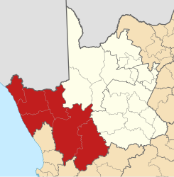
Namakwa
| Namakwa Namakwa District Municipality |
||
|---|---|---|
 |
||
| Symbols | ||
|
||
| Basic data | ||
| Country | South Africa | |
| province | North Cape | |
| Seat | Springbok | |
| surface | 126,836 km² | |
| Residents | 115,842 (October 2011) | |
| density | 0.9 inhabitants per km² | |
| key | DC6 | |
| ISO 3166-2 | ZA-NC | |
| Website | www.namakwa-dm.gov.za (English) | |
| politics | ||
| mayor | B. Vass | |
Coordinates: 29 ° 40 ′ S , 17 ° 53 ′ E
Namakwa ( Namakwa District Municipality , Afrikaans Namakwa-distriksmunisipaliteit , also Namaqua) is a district in the Northern Cape Province in South Africa . It has 115,842 inhabitants (as of October 2011) on a total area of 126,836 km². The district capital is Springbok . The district is named after the Nama who live there . and it corresponds to the majority of landscape small Namaqualand ( Little Namaqualand ).
geography
Namaqua is bordered by the Atlantic Ocean to the west and the Republic of Namibia by the Orange River to the north .
Neighboring districts are:
- ZF Mgcawu , formerly Siyanda
- Pixley Ka Seme
- Central Karoo
- Cape Winelands
- West coast
Municipalities (local Municipality)
Cities and other places
Aggeneys, Alexander Bay , Brandvlei , Calvinia , Carolusberg, Concordia, Eksteenfontein, Fraserburg, Garies , Hondeklip Bay, Kamieskroon, Kleinzee , Komaggas, Kuboes, Lekkersing, Leliefontein, Loeriesfontein , McDougall's Bay, Nababeep , Nieuwoudtville , Okiep , Onseepkans, Pella , Pofadder , Port Nolloth , Sanddrif, Soebatsfontein, Springbok , Steinkopf, Sutherland , Vioolsdrift and Williston
National parks and nature reserves
- ǀAi-ǀAis Richtersveld Transfrontier Park
- Akkerendam Nature Reserve
- Augrabies Falls National Park
- Kgalagadi Transfrontier Park
- Goegap Nature Reserve
- Mokala National Park
- Namaqua National Park
- Oorlogskloof Nature Reserve
- Spitskop Nature Reserve
- Tankwa Karoo National Park
- Tswalu Desert Reserve
- Witsand Nature Reserve
Web links
- Portrait at localgovernment.co.za (English)
Individual evidence
- ^ Census 2011. Basic Results. (PDF; 349 kB) Statistics South Africa , accessed on November 27, 2015 (English).
- ^ Municipal boundaries South Africa
- ↑ Meaning of the name municipalities ( Memento from August 29, 2019 in the Internet Archive ) (English)
