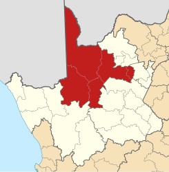
ZF Mgcawu
| ZF Mgcawu ZF Mgcawu District Municipality |
|
|---|---|
 |
|
| Basic data | |
| Country | South Africa |
| province | North Cape |
| Seat | Upington |
| surface | 102,524 km² |
| Residents | 236,783 (October 2011) |
| density | 2.3 inhabitants per km² |
| key | DC8 |
| ISO 3166-2 | ZA-NC |
| Website | www.zfm-dm.co.za (English) |
| politics | |
| mayor | Abraham Vosloo |
Coordinates: 28 ° 27 ' S , 21 ° 15' E
ZF Mgcawu District Municipality (2013 before July Siyanda ) is a district in the province of Northern Cape in South Africa . It has 236,783 inhabitants (as of October 2011) on a total area of 102,524 km². The district capital is Upington .
ZF Mgcawu borders Botswana to the north and Namibia to the west . Adjacent South African districts are John Taolo Gaetsewe , Frances Baard , Pixley Ka Seme and Namakwa .
climate
The North Cape is known for its extreme climates and the ZF Mgcawu District is no exception. The landscape is determined by the Kalahari desert with its red sand dunes. The district is a semi-desert , with little summer rain, the average rainfall is between 150 and 200 mm per year.
The highest summer temperatures in South Africa occur in this district - temperatures of more than 43 ° C are measured regularly between November and February. On the other hand, winter temperatures often drop below 0 ° C between June and August.
Municipalities ( Local Municipality ) with their largest cities
-
Dawid Kruiper
- Upington , Raaswater, Louisvale, Kalksloot, Leerkrans, Karos, Lambrechtsdrift, Rietfontein, Askham, Noenieput, Grootmier, Kleinmier
- Kai ǃGarib
-
Kgatelopele
- Danielskuil, Lime Acres
-
ǃKheis
- Groblershoop, Grootdrink, Wegdraai, Topline
-
Tsantsabane
- Postmasburg, Olifantshoek, Groenwater, Skeyfontein
National parks and nature reserves
- Augrabies Falls National Park
- Kgalagadi Transfrontier Park (formerly Kalahari Gemsbok NP)
Web links
- Official website (English)
- Portrait at localgovernment.co.za (English)
Individual evidence
- ^ Census 2011. Basic Results. (PDF; 349 kB) Statistics South Africa , accessed on November 27, 2015 (English).
- ↑ Page no longer available , search in web archives: Community boundaries South Africa