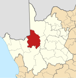
Kai ǃGarib
| Kai ǃGarib Kai ǃGarib Local Municipality |
||
|---|---|---|
 |
||
| Symbols | ||
|
||
| Basic data | ||
| Country | South Africa | |
| province | North Cape | |
| District | ZF Mgcawu | |
| Seat | Kakamas | |
| surface | 7446 km² | |
| Residents | 65,869 (October 2011) | |
| density | 8.8 inhabitants per km² | |
| key | NC082 | |
| ISO 3166-2 | ZA-NC | |
| Website | www.kaigarib.gov.za (English) | |
| politics | ||
| mayor | Marius Louw | |
Coordinates: 28 ° 42 ′ S , 20 ° 58 ′ E
Kai ǃGarib ( English Kai ǃGarib Local Municipality ) is a local municipality in the ZF Mgcawu district of the South African province of Northern Cape . The seat of the local government is in Kakamas . Mayor is Marius Louw.
The community is named after the Khoi term for "large river". The name refers to the Orange River (Gariep) that flows through the parish.
Localities
- Ality
Named after Christian Wilhelm Alheit (1817–1882), a missionary of the Rheinische Missionsgesellschaft ; the place is eight kilometers west of Kakamas and 30 kilometers southeast of the Augrabies Falls at the intersection of roads N14 and R359 on the Orange River.
- Augrabies
- Bloemsmond
- Cillie
- Kakamas
- Canon island
- Keimoes
- Kenhardt
- Lennetsville
- Louis Vale
- Loxtonberg
- Lutzburg
- Marchand
- Neilersdrif
- Raaswater
- Riemvasmaak
- Rugseer
- Schroder
population
In 2011 the community had 65,869 inhabitants. Of these, 62.2% were colored , 28.3% black and 6.3% white. 71.1 % of the participants spoke Afrikaans, 23.9% Setswana and 1.2% English.
Web links
- The community site (English)
Individual evidence
- ^ Local Government Handbook. South Africa: Kai! Garib Local Municipality (NC082) . at www.municipalities.co.za (English).
- ^ Department of Arts and Culture: Place Names . at www.salanguages.com (English).
- ↑ 2011 census: Kai! Garib . accessed on August 25, 2020.
- ^ Statistics South Africa : Kai! Garib . at www.statssa.gov.za (English).
