Stampriet
| Village Stampriet
|
|||
|---|---|---|---|
|
|||
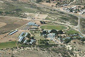
| A bird's eye view of the western part of Stampriet | |||
| motto | - | ||
| Basic data | |||
|
Population Area Population Density |
|
||
|
State Region Constituency |
Namibia Hardap Mariental-Land |
||
| Establishment date | |||
|
License plate phone code |
|
||
| Website | |||
|
Geographical data
Geographical coordinates : 24 ° 20′0 "S, 18 ° 24′0" E Height : 1177 m |
|||
Stampriet is a village in Namibia , around 40 kilometers east of Mariental . The place belongs to the constituency of Mariental Land . Stampriet is located at an altitude of 1177 m in a fertile river oasis of the Auob - Riviers and is therefore, in contrast to its surrounding area and the western foothills of the Kalahari , relatively green. It is the administrative seat of the constituency of Mariental-Land .
Stampriet was founded in 1898 as a trading post in German South West Africa and has repeatedly been the scene of armed conflicts between Germans and Nama. Stampriet is the intersection of the main roads Hauptstrasse C15 and C20 and has an airport. The village is known for its vegetable growing . There are two hotels here, including the Gondwana Collection and one of the most prestigious private schools in Namibia ( Privaatskool Elnatan ).
Local politics
The following official final result was determined in the 2015 local elections .
| Political party | be right | Share of votes | Seats |
|---|---|---|---|
| SWAPO | 460 | 82.9% | 4th |
| DTA | 63 | 11.4% | 1 |
| RDP | 32 | 5.8% | 0 |
| All in all | 555 | 100% | 5 |
Web links
- Privaatskool Elnatan (Afrikaans)
Individual evidence
- ↑ Official election result of the regional and local elections 2015, ECN, December 4, 2015 ( Memento of the original of December 10, 2015 in the Internet Archive ) Info: The archive link was inserted automatically and has not yet been checked. Please check the original and archive link according to the instructions and then remove this notice. (PDF; 150 kB)
Coordinates: 24 ° 20 ′ S , 18 ° 24 ′ E


