National road B2
| National road B2 in Namibia | |||||||||||||||||||||||||||||||||||||||||||||||||||||||

|
|||||||||||||||||||||||||||||||||||||||||||||||||||||||
| |
|||||||||||||||||||||||||||||||||||||||||||||||||||||||
| map | |||||||||||||||||||||||||||||||||||||||||||||||||||||||
| Basic data | |||||||||||||||||||||||||||||||||||||||||||||||||||||||
| Operator: | Roads Authority | ||||||||||||||||||||||||||||||||||||||||||||||||||||||
| Overall length: | 320 km | ||||||||||||||||||||||||||||||||||||||||||||||||||||||
| of which in operation: | 320 km | ||||||||||||||||||||||||||||||||||||||||||||||||||||||
|
Regions : |
|||||||||||||||||||||||||||||||||||||||||||||||||||||||
| Development condition: | Asphalt - two lanes, partly in the 2 + 1 system | ||||||||||||||||||||||||||||||||||||||||||||||||||||||
| The B2 national road between Swakopmund and Walvis Bay looking south |
|||||||||||||||||||||||||||||||||||||||||||||||||||||||
|
Course of the road
|
|||||||||||||||||||||||||||||||||||||||||||||||||||||||
The Namibian national road B2 is an important west-east connection between the country's only deep-sea port on the south Atlantic coast and the central inland . The national road is part of the SADC highways Trans-Kalahari to Botswana and Walvis Bay-Ndola-Lubumbashi to Zambia .
Route
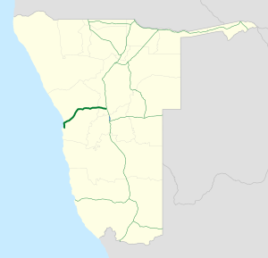
The national road B2 begins in the port city of Walvis Bay and connects Namibia's largest deep-sea port WVB , as well as the international airport WVB to the national road network. It continues north to Swakopmund 35 km away and crosses the 587 m long Swakop Bridge at the mouth of the Swakop in the South Atlantic. The route of the B2 bends west in Swakopmund and leads over Arandis , past the Rössing opencast mine and the Spitzkoppe , to Okahandja . There the B2 ends after 320 km with the transition to the national road B1 .
Road conditions
The entire length of the B2 national road has been developed as a two-lane paved highway. The section between Karibib and the end point in Okahandja is continuous with a side strip provided. On a section between Wilhelmstal and Okahandja is the B2 in 2 + 1 system , with so-called english Climbing Lanes ( " climbing tracks applied") to the overtaking of the heavy traffic to facilitate in hilly terrain.
Future development
Since a four-lane expansion of the directly adjacent main road C34 from Walvis Bay to Swakopmund to the motorway is under construction, the national road B2 on this 35 km long section will lose importance in the coming years. It remains to be seen whether the new motorway will be freely passable or will be operated as a toll route.


